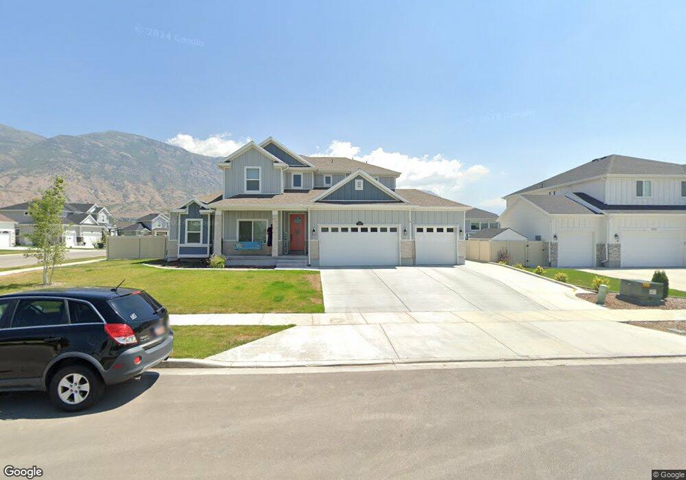
498 N 1250 E American Fork, UT 84003
Estimated Value: $827,000 - $1,158,867
4
Beds
5
Baths
2,952
Sq Ft
$358/Sq Ft
Est. Value
About This Home
This home is located at 498 N 1250 E, American Fork, UT 84003 and is currently estimated at $1,057,967, approximately $358 per square foot. 498 N 1250 E is a home with nearby schools including Barratt Elementary School, American Fork Junior High School, and American Fork High School.
Ownership History
Date
Name
Owned For
Owner Type
Purchase Details
Closed on
Jul 12, 2021
Sold by
Lambourne Brett Richard and Reusen Lambourne Alysha
Bought by
Lambourne Brett Richard and Lambourne Alysha Elizabeth
Current Estimated Value
Home Financials for this Owner
Home Financials are based on the most recent Mortgage that was taken out on this home.
Original Mortgage
$225,000
Interest Rate
2.2%
Mortgage Type
New Conventional
Create a Home Valuation Report for This Property
The Home Valuation Report is an in-depth analysis detailing your home's value as well as a comparison with similar homes in the area
Home Values in the Area
Average Home Value in this Area
Purchase History
| Date | Buyer | Sale Price | Title Company |
|---|---|---|---|
| Lambourne Brett Richard | -- | First American American Fork |
Source: Public Records
Mortgage History
| Date | Status | Borrower | Loan Amount |
|---|---|---|---|
| Closed | Lambourne Brett Richard | $225,000 |
Source: Public Records
Tax History Compared to Growth
Tax History
| Year | Tax Paid | Tax Assessment Tax Assessment Total Assessment is a certain percentage of the fair market value that is determined by local assessors to be the total taxable value of land and additions on the property. | Land | Improvement |
|---|---|---|---|---|
| 2025 | $4,767 | $580,470 | $262,100 | $793,300 |
| 2024 | $4,767 | $529,705 | $0 | $0 |
| 2023 | $4,655 | $548,350 | $0 | $0 |
| 2022 | $4,575 | $531,905 | $0 | $0 |
| 2021 | $3,583 | $650,600 | $183,500 | $467,100 |
| 2020 | $3,468 | $610,700 | $169,900 | $440,800 |
| 2019 | $1,624 | $162,700 | $162,700 | $0 |
Source: Public Records
Map
Nearby Homes
- 2254 N 1560 W
- 598 N 1280 E
- 649 N 1280 E
- 636 N 1280 E
- 1121 E 580 N
- 980 W 1800 N
- 1897 N 900 W
- 2969 N 1350 W
- 1141 E 50 N
- 435 N 800 E
- 1320 W 1340 N
- 1228 E 1030 N
- 170 N 825 E
- 290 Chipman Ave
- 1171 N 1430 W
- 1045 N 930 E Unit 58
- The McKenzie Plan at Autumn Crest
- The Christine Plan at Autumn Crest
- The Avery Plan at Autumn Crest
- The Madison Plan at Autumn Crest
- 492 N 1250 E
- 499 N 1290 E
- 485 N 1290 E
- 1243 E 490 N
- 1261 E 500 N
- 482 N 1250 E
- 1253 E 500 N Unit 324
- 473 N 1290 E
- 1275 E 500 N Unit 326
- 1246 E 490 N
- 1246 E 490 N Unit 401
- 466 N 1250 E
- 1233 E 490 N Unit 421
- 486 N 1290 E Unit 329
- 469 N 1290 E
- 496 N 1290 E
- 1287 E 500 N Unit 327
- 1224 E 490 N Unit 402
- 472 N 1290 E
- 458 N 1250 E