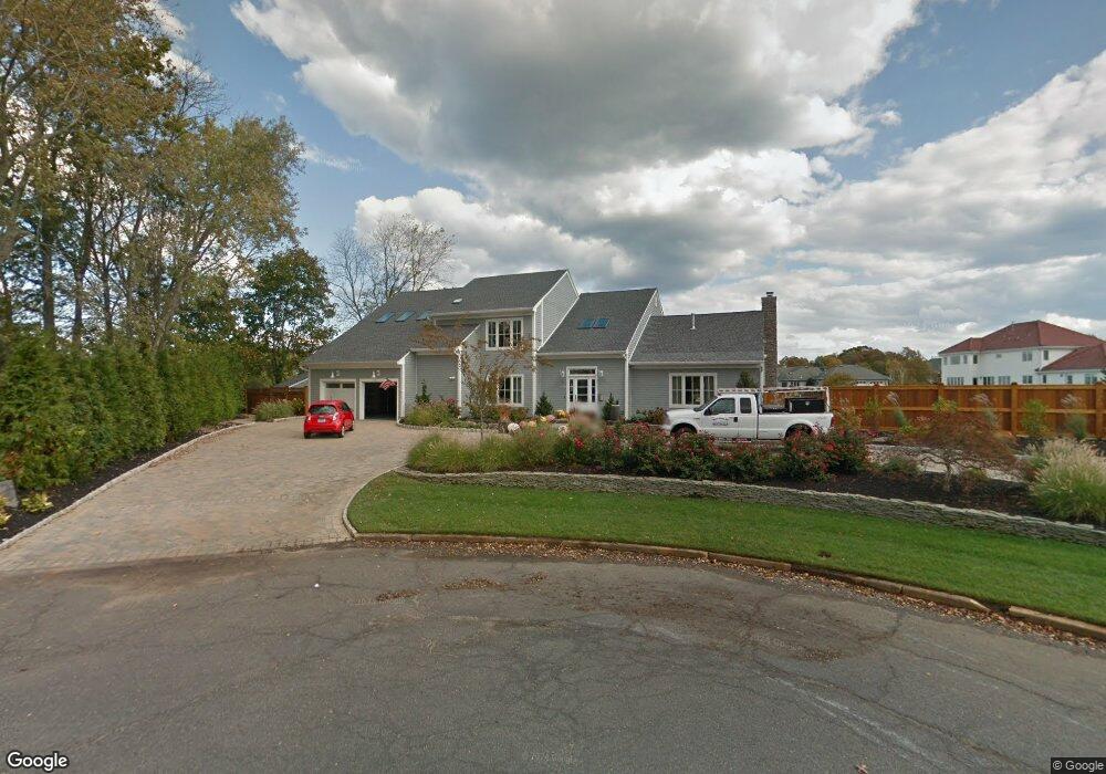
5 Blackberry Bay Dr Oceanport, NJ 07757
Estimated Value: $2,284,000 - $2,801,000
5
Beds
3
Baths
4,725
Sq Ft
$544/Sq Ft
Est. Value
About This Home
This home is located at 5 Blackberry Bay Dr, Oceanport, NJ 07757 and is currently estimated at $2,568,731, approximately $543 per square foot. 5 Blackberry Bay Dr is a home located in Monmouth County with nearby schools including Wolf Hill Elementary School, Maple Place Elementary and Middle School, and Shore Regional High School.
Ownership History
Date
Name
Owned For
Owner Type
Purchase Details
Closed on
Jul 28, 2010
Sold by
Triano Janine
Bought by
Turner Paul and Turner Frances
Current Estimated Value
Purchase Details
Closed on
Apr 2, 2008
Sold by
Hanrahan William
Bought by
Hanrahan William and Hanrahan Qualified Personal Residence Tr
Create a Home Valuation Report for This Property
The Home Valuation Report is an in-depth analysis detailing your home's value as well as a comparison with similar homes in the area
Home Values in the Area
Average Home Value in this Area
Purchase History
| Date | Buyer | Sale Price | Title Company |
|---|---|---|---|
| Turner Paul | $303,125 | First Jersey Title Svcs Inc | |
| Hanrahan William | -- | Fidelity National Title Ins |
Source: Public Records
Tax History Compared to Growth
Tax History
| Year | Tax Paid | Tax Assessment Tax Assessment Total Assessment is a certain percentage of the fair market value that is determined by local assessors to be the total taxable value of land and additions on the property. | Land | Improvement |
|---|---|---|---|---|
| 2025 | $28,574 | $1,899,200 | $931,000 | $968,200 |
| 2024 | $29,261 | $1,809,600 | $883,500 | $926,100 |
| 2023 | $29,261 | $1,758,500 | $878,700 | $879,800 |
| 2022 | $25,706 | $1,463,300 | $688,700 | $774,600 |
| 2021 | $25,706 | $1,349,400 | $612,700 | $736,700 |
| 2020 | $24,351 | $1,332,100 | $608,000 | $724,100 |
| 2019 | $23,364 | $1,297,300 | $598,500 | $698,800 |
| 2018 | $23,058 | $1,288,900 | $598,500 | $690,400 |
| 2017 | $24,130 | $1,118,700 | $522,300 | $596,400 |
| 2016 | $23,732 | $1,107,400 | $522,300 | $585,100 |
| 2015 | $23,098 | $1,069,900 | $522,300 | $547,600 |
| 2014 | $23,697 | $1,158,800 | $636,200 | $522,600 |
Source: Public Records
Map
Nearby Homes
- 3 Foggia Way
- 10 Asbury Ave
- 66 Shrewsbury Ave
- 1 Carriage House Ln
- 265 Port Au Peck Ave
- 8 Pocahontas Ave
- 15 Signal Ave
- 13 Morris Place
- 580 Patten Ave Unit 48
- 580 Patten Ave Unit 62
- 580 Patten Ave Unit 86
- 580 Patten Ave Unit 31
- 14 Oceanport Ave
- 94 Paddock Ct
- 28 Patten Ln
- 222 Coleman Ave
- 3 Sandbar Aly
- 238 Branchport Ave
- 572 Jay St
- 16 Shore Dr
- 6 Blackberry Bay Dr
- 4 Blackberry Bay Dr
- 5 Blue Point Cove
- 6 Blue Point Cove
- 4 Blue Point Cove
- 12 Shore Rd
- 8 Blackberry Bay Dr
- 20 Shore Rd
- 3 Blackberry Bay Dr
- 8 Shore Rd
- 481 Myrtle Ave
- 477 Myrtle Ave
- 3 Blue Point Cove
- 24 Gooseneck Point Rd
- 2 Gooseneck Point Rd
- 1 Blue Point Cove
- 473 Myrtle Ave
- 189 Monmouth Blvd
- 2 Blue Point Cove
- 25 Shore Rd