Estimated Value: $1,062,253 - $1,320,000
5
Beds
4
Baths
2,684
Sq Ft
$451/Sq Ft
Est. Value
About This Home
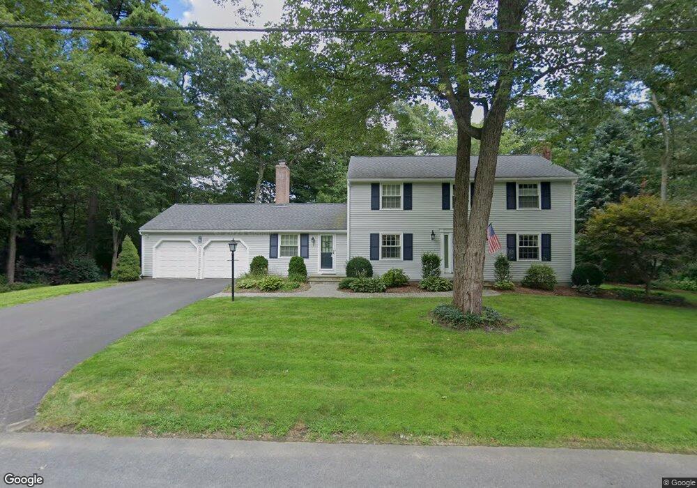
This home is located at 5 Captain Forbush Ln, Acton, MA 01720 and is currently estimated at $1,210,313, approximately $450 per square foot. 5 Captain Forbush Ln is a home located in Middlesex County with nearby schools including Acton-Boxborough Regional High School and The Imago School.
Ownership History
Date
Name
Owned For
Owner Type
Purchase Details
Closed on
May 26, 2021
Sold by
Viola Richard B and Viola Brenda L
Bought by
Viola Ft
Current Estimated Value
Purchase Details
Closed on
Oct 16, 1991
Sold by
Costello Raymond and Costello Kathryn
Bought by
Viola Richard B and Viola Brenda
Create a Home Valuation Report for This Property
The Home Valuation Report is an in-depth analysis detailing your home's value as well as a comparison with similar homes in the area
Home Values in the Area
Average Home Value in this Area
Purchase History
| Date | Buyer | Sale Price | Title Company |
|---|---|---|---|
| Viola Ft | -- | None Available | |
| Viola Richard B | $272,500 | -- |
Source: Public Records
Mortgage History
| Date | Status | Borrower | Loan Amount |
|---|---|---|---|
| Previous Owner | Viola Richard B | $218,000 | |
| Previous Owner | Viola Richard B | $205,000 | |
| Previous Owner | Viola Richard B | $200,000 | |
| Previous Owner | Viola Richard B | $190,000 |
Source: Public Records
Tax History Compared to Growth
Tax History
| Year | Tax Paid | Tax Assessment Tax Assessment Total Assessment is a certain percentage of the fair market value that is determined by local assessors to be the total taxable value of land and additions on the property. | Land | Improvement |
|---|---|---|---|---|
| 2025 | $15,905 | $927,400 | $369,600 | $557,800 |
| 2024 | $14,856 | $891,200 | $369,600 | $521,600 |
| 2023 | $14,487 | $825,000 | $335,900 | $489,100 |
| 2022 | $13,718 | $705,300 | $292,100 | $413,200 |
| 2021 | $13,388 | $661,800 | $270,300 | $391,500 |
| 2020 | $12,847 | $667,700 | $270,300 | $397,400 |
| 2019 | $12,329 | $636,500 | $270,300 | $366,200 |
| 2018 | $12,114 | $625,100 | $270,300 | $354,800 |
| 2017 | $11,806 | $619,400 | $270,300 | $349,100 |
| 2016 | $11,582 | $602,300 | $270,300 | $332,000 |
| 2015 | $11,312 | $593,800 | $270,300 | $323,500 |
| 2014 | $10,945 | $562,700 | $270,300 | $292,400 |
Source: Public Records
Map
Nearby Homes
- 285 Central St Unit 285
- 9 Elm St Unit 1
- 5 Elm St Unit 1
- 89 Windsor Ave
- 31 Mohawk Dr
- 4,7,8 Crestwood Ln
- 169 Main St
- 92 Willow St Unit 3
- 92 Willow St Unit 2
- 90 Willow St Unit 1
- 4 Huron Rd
- 46 Taylor Rd
- 19 Railroad St Unit C2
- 23 John Swift Rd
- 129 Main St Unit 129
- 129 Main St
- 131 Main St
- 8 Laurel Ct
- 86 School St
- 68 Macintosh Ln
- 12 Captain Browns Ln
- 14 Captain Browns Ln
- 7 Captain Forbush Ln
- 3 Captain Forbush Ln
- 8 Captain Forbush Ln
- 8 Capt Forbush La
- 6 Captain Forbush Ln
- 10 Captain Browns Ln
- 16 Captain Browns Ln
- 16 Captain Brown's Ln
- 10 Captain Forbush Ln
- 15 Deacon Hunt Dr
- 9 Captain Forbush Ln
- 4 Captain Forbush Ln
- 15 Captain Browns Ln
- 11 Captain Browns Ln
- 13 Deacon Hunt Dr
- 17 Captain Browns Ln
- 17 Deacon Hunt Dr
- 2 Captain Forbush Ln