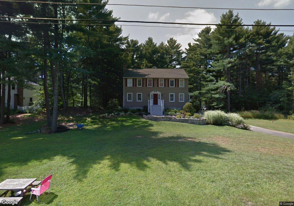
5 Chickadee Dr Norfolk, MA 02056
Estimated Value: $817,608 - $899,000
4
Beds
3
Baths
2,260
Sq Ft
$379/Sq Ft
Est. Value
About This Home
This home is located at 5 Chickadee Dr, Norfolk, MA 02056 and is currently estimated at $857,402, approximately $379 per square foot. 5 Chickadee Dr is a home located in Norfolk County with nearby schools including H. Olive Day School and Freeman-Kennedy School.
Ownership History
Date
Name
Owned For
Owner Type
Purchase Details
Closed on
Feb 19, 1999
Sold by
Zaremba Joseph A and Zaremba Christine A
Bought by
Murray Jay R and Murray Jennifer M
Current Estimated Value
Home Financials for this Owner
Home Financials are based on the most recent Mortgage that was taken out on this home.
Original Mortgage
$271,700
Outstanding Balance
$64,365
Interest Rate
6.75%
Mortgage Type
Purchase Money Mortgage
Estimated Equity
$793,037
Purchase Details
Closed on
May 27, 1997
Sold by
Johansson Brian D and Johansson Annne S
Bought by
Zaremba Joseph A and Zaremba Christina A
Home Financials for this Owner
Home Financials are based on the most recent Mortgage that was taken out on this home.
Original Mortgage
$154,000
Interest Rate
8.08%
Mortgage Type
Purchase Money Mortgage
Purchase Details
Closed on
Aug 22, 1991
Sold by
Mulcahy Henry L and Mulcahy Patricia J
Bought by
Johansson Brian D and Johansson Anne S
Create a Home Valuation Report for This Property
The Home Valuation Report is an in-depth analysis detailing your home's value as well as a comparison with similar homes in the area
Home Values in the Area
Average Home Value in this Area
Purchase History
| Date | Buyer | Sale Price | Title Company |
|---|---|---|---|
| Murray Jay R | $286,000 | -- | |
| Zaremba Joseph A | $259,000 | -- | |
| Johansson Brian D | $200,000 | -- |
Source: Public Records
Mortgage History
| Date | Status | Borrower | Loan Amount |
|---|---|---|---|
| Open | Johansson Brian D | $271,700 | |
| Previous Owner | Johansson Brian D | $154,000 | |
| Previous Owner | Johansson Brian D | $154,000 |
Source: Public Records
Tax History Compared to Growth
Tax History
| Year | Tax Paid | Tax Assessment Tax Assessment Total Assessment is a certain percentage of the fair market value that is determined by local assessors to be the total taxable value of land and additions on the property. | Land | Improvement |
|---|---|---|---|---|
| 2025 | $10,732 | $672,000 | $195,400 | $476,600 |
| 2024 | $10,328 | $663,300 | $203,400 | $459,900 |
| 2023 | $9,885 | $602,400 | $203,400 | $399,000 |
| 2022 | $9,209 | $506,000 | $191,200 | $314,800 |
| 2021 | $8,912 | $495,400 | $197,500 | $297,900 |
| 2020 | $9,309 | $499,400 | $198,400 | $301,000 |
| 2019 | $8,969 | $490,400 | $198,400 | $292,000 |
| 2018 | $8,805 | $472,900 | $207,900 | $265,000 |
| 2017 | $8,676 | $476,200 | $207,900 | $268,300 |
| 2016 | $8,639 | $477,800 | $214,600 | $263,200 |
| 2015 | $8,316 | $470,900 | $204,300 | $266,600 |
| 2014 | $8,155 | $467,900 | $204,300 | $263,600 |
Source: Public Records
Map
Nearby Homes
- 14 Robin Rd
- 45 King St
- 26 Ridge Rd
- 23 Fredrickson Rd
- 38 Robin Rd
- 3 Pheasanthill Rd
- 14 Essex St
- 45 Joshua Rd
- 2 Diamond St
- 6 Trailside Way
- 8 Analore Cir
- 6 Forest Grove Ave
- 246 Forest Grove Ave
- 48 Mirror Lake Ave
- 7 Keeney Pond Rd
- 10 W Birch Rd
- 18 Keeney Pond Rd
- 20 Waites Crossing
- 13 Waites Crossing
- 19 Waites Crossing