
Seller's Agent in 2026
Kathleen Sitek
Berkshire Hathaway Home Services
(860) 729-1133
19 in this area
229 Total Sales
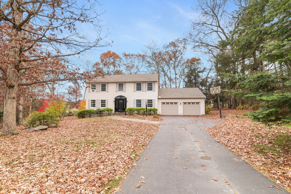
Welcome to this charming 3/4-bedroom, 3-full-bath colonial offering 2,240 sq. ft. of comfortable living space, set on a beautifully landscaped .92-acre lot. With a walk-out lower level and an inviting in-ground pool, this home delivers the perfect blend of indoor comfort and outdoor enjoyment. Step inside to a stunning updated eat-in kitchen featuring newer cabinets, a spacious 3' x 6' center island, SS appliances, and a built-in bookcase for added style and storage. A slider leads to the private deck overlooking the pool-an ideal spot for morning coffee or summer entertaining. The dining room off the kitchen adds flexibility and could easily serve as a fourth bedroom if desired. The cozy family room offers a warm brick fireplace and gleaming hardwood floors, while the living room provides a peaceful retreat for quiet relaxation. A convenient first-floor full bath completes the main level. Upstairs, the primary bedroom suite boasts an impressive 9' x 12' walk-in closet-perfect for a dream California Closet redesign-and an oversized unfinished full bath with endless potential to create your own spa-like sanctuary. Two additional generously sized bedrooms and another full bath round out the upper level. Additional updates include an oil furnace, hot water heater, garage doors, arch. roof, and a newer driveway, offering peace of mind for years to come. With a two-car garage and a serene setting, this home is ready to welcome its next owner. Subject to probate approval
Last Agent to Sell the Property
Berkshire Hathaway NE Prop. Brokerage Phone: (860) 729-1133 License #RES.0755047 Listed on: 11/20/2025
| Date | Type | Sale Price | Title Company |
|---|---|---|---|
| Warranty Deed | $520,000 | -- | |
| Warranty Deed | $315,000 | -- | |
| Warranty Deed | $154,545 | -- |
| Date | Status | Loan Amount | Loan Type |
|---|---|---|---|
| Open | $370,000 | New Conventional | |
| Previous Owner | $283,185 | Purchase Money Mortgage | |
| Previous Owner | $143,000 | No Value Available | |
| Previous Owner | $136,800 | Purchase Money Mortgage |
| Date | Event | Price | List to Sale | Price per Sq Ft |
|---|---|---|---|---|
| 01/15/2026 01/15/26 | Sold | $520,000 | +4.0% | $232 / Sq Ft |
| 12/27/2025 12/27/25 | Pending | -- | -- | -- |
| 11/20/2025 11/20/25 | For Sale | $499,900 | -- | $223 / Sq Ft |
| Year | Tax Paid | Tax Assessment Tax Assessment Total Assessment is a certain percentage of the fair market value that is determined by local assessors to be the total taxable value of land and additions on the property. | Land | Improvement |
|---|---|---|---|---|
| 2025 | $8,818 | $237,680 | $64,400 | $173,280 |
| 2024 | $8,556 | $237,680 | $64,400 | $173,280 |
| 2023 | $8,152 | $237,680 | $64,400 | $173,280 |
| 2022 | $7,725 | $237,680 | $64,400 | $173,280 |
| 2021 | $7,511 | $237,680 | $64,400 | $173,280 |
| 2020 | $7,437 | $228,130 | $65,010 | $163,120 |
| 2019 | $7,437 | $228,130 | $65,010 | $163,120 |
| 2016 | $6,898 | $226,150 | $65,010 | $161,140 |
| 2015 | $7,053 | $231,250 | $65,010 | $166,240 |
| 2014 | $6,637 | $231,250 | $65,010 | $166,240 |
Seller's Agent in 2026
Kathleen Sitek
Berkshire Hathaway Home Services
(860) 729-1133
19 in this area
229 Total Sales
Buyer's Agent in 2026
Diana Brown
William Raveis Real Estate
(860) 559-0638
13 in this area
161 Total Sales
Source: SmartMLS
MLS Number: 24140285
APN: ELLI-000181-000010-000003
Disclaimer: Certain information contained herein is derived from information provided by parties other than Homes.com. All information provided is deemed reliable, but is not guaranteed to be accurate and should be independently verified.
![]() IDX information is provided exclusively for personal, non-commercial use, and may not be used for any purpose other than to identify prospective properties consumers may be interested in purchasing. Information is deemed reliable but not guaranteed.
IDX information is provided exclusively for personal, non-commercial use, and may not be used for any purpose other than to identify prospective properties consumers may be interested in purchasing. Information is deemed reliable but not guaranteed.
Ask me questions while you tour the home.