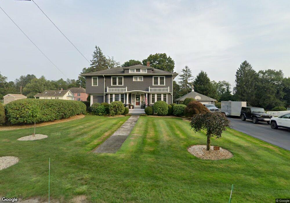
5 Cross St South Grafton, MA 01560
Estimated Value: $396,000 - $770,000
5
Beds
2
Baths
2,724
Sq Ft
$227/Sq Ft
Est. Value
About This Home
This home is located at 5 Cross St, South Grafton, MA 01560 and is currently estimated at $618,338, approximately $226 per square foot. 5 Cross St is a home located in Worcester County with nearby schools including Grafton High School, Silver Spruce Montessori School, and Touchstone Community School.
Ownership History
Date
Name
Owned For
Owner Type
Purchase Details
Closed on
Dec 31, 2001
Sold by
Moen Diane E and Matuzek Diane
Bought by
Matuzek Stanley G and Matuzek Elizabeth
Current Estimated Value
Home Financials for this Owner
Home Financials are based on the most recent Mortgage that was taken out on this home.
Original Mortgage
$198,750
Interest Rate
6.61%
Mortgage Type
Purchase Money Mortgage
Create a Home Valuation Report for This Property
The Home Valuation Report is an in-depth analysis detailing your home's value as well as a comparison with similar homes in the area
Home Values in the Area
Average Home Value in this Area
Purchase History
| Date | Buyer | Sale Price | Title Company |
|---|---|---|---|
| Matuzek Stanley G | $75,000 | -- | |
| Matuzek Stanley G | $75,000 | -- | |
| Matuzek Stanley G | $75,000 | -- |
Source: Public Records
Mortgage History
| Date | Status | Borrower | Loan Amount |
|---|---|---|---|
| Open | Matuzek Stanley G | $299,145 | |
| Closed | Matuzek Stanley G | $198,750 |
Source: Public Records
Tax History Compared to Growth
Tax History
| Year | Tax Paid | Tax Assessment Tax Assessment Total Assessment is a certain percentage of the fair market value that is determined by local assessors to be the total taxable value of land and additions on the property. | Land | Improvement |
|---|---|---|---|---|
| 2025 | $7,182 | $515,200 | $163,300 | $351,900 |
| 2024 | $6,919 | $483,500 | $155,500 | $328,000 |
| 2023 | $6,851 | $436,100 | $155,500 | $280,600 |
| 2022 | $6,330 | $375,000 | $133,500 | $241,500 |
| 2021 | $6,128 | $356,700 | $121,400 | $235,300 |
| 2020 | $5,070 | $307,300 | $121,400 | $185,900 |
| 2019 | $5,121 | $307,400 | $113,800 | $193,600 |
| 2018 | $5,181 | $312,300 | $113,500 | $198,800 |
| 2017 | $4,753 | $289,800 | $86,400 | $203,400 |
| 2016 | $4,434 | $264,700 | $91,000 | $173,700 |
| 2015 | $4,330 | $262,400 | $91,000 | $171,400 |
| 2014 | $3,946 | $258,600 | $100,700 | $157,900 |
Source: Public Records
Map
Nearby Homes
- 29 Sampson St Unit 29
- 44 Fisherville Terrace
- 58 Fisherville Terrace
- 55 Fisherville Terrace
- 110 Main St
- 109 Main St
- 7 Pine Hill Rd
- 151 Providence Rd Unit 24
- 191 Hartness Rd
- 150 Sprague St
- 395 Providence Rd Unit 4
- 13 Pullard Rd Unit 38
- 19 Milford Rd
- 29 Pullard Rd
- 51 Londonderry Rd Unit 51
- 70 Londonderry Rd
- 185 Main St
- 86 Mikes Way Unit 86
- 84 Mikes Way Unit 84
- 42 Gordon Cir Unit 42
- 258 Providence Rd
- 7 Cross St
- 256 Providence Rd
- 260 Providence Rd
- 9 Cross St
- 4 Cross St
- 6 Cross St
- 262 Providence Rd
- 254 Providence Rd
- 8 Cross St
- 11 Cross St
- 255 Providence Rd
- 252 Providence Rd
- 15 Cross St
- 12 Cross St
- 10 Cross St Unit 2A
- 10 Cross St Unit 3D
- 10 Cross St Unit 2C
- 10 Cross St Unit 3B
- 10 Cross St Unit 1C