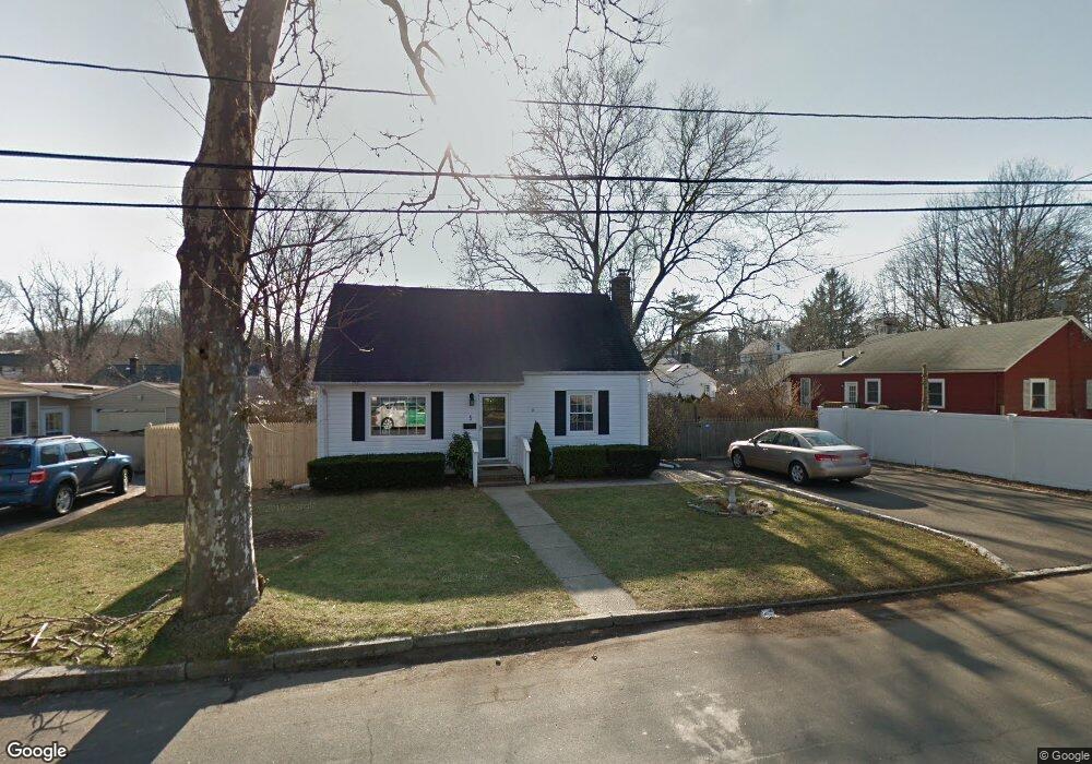
5 Devonshire Place Huntington Station, NY 11746
Estimated Value: $565,256 - $719,000
--
Bed
--
Bath
--
Sq Ft
0.25
Acres
About This Home
This home is located at 5 Devonshire Place, Huntington Station, NY 11746 and is currently estimated at $654,814. 5 Devonshire Place is a home located in Suffolk County with nearby schools including Woodhull Intermediate School, Washington School, and J Taylor Finley Middle School.
Ownership History
Date
Name
Owned For
Owner Type
Purchase Details
Closed on
Nov 27, 2007
Sold by
Manaseri Alison Marie
Bought by
Tetrault Keith
Current Estimated Value
Purchase Details
Closed on
Mar 25, 2003
Sold by
Mccann Michael and Mccann Cynthia
Bought by
Manaseri Alison Marie
Home Financials for this Owner
Home Financials are based on the most recent Mortgage that was taken out on this home.
Original Mortgage
$171,500
Interest Rate
5.88%
Purchase Details
Closed on
Apr 11, 1996
Sold by
Bell Stephen T
Bought by
Mccann Michael and Mccann Cynthia
Create a Home Valuation Report for This Property
The Home Valuation Report is an in-depth analysis detailing your home's value as well as a comparison with similar homes in the area
Home Values in the Area
Average Home Value in this Area
Purchase History
| Date | Buyer | Sale Price | Title Company |
|---|---|---|---|
| Tetrault Keith | $415,000 | Albert J Rodrigues | |
| Manaseri Alison Marie | $291,500 | First American Title Ins Co | |
| Mccann Michael | $122,000 | -- |
Source: Public Records
Mortgage History
| Date | Status | Borrower | Loan Amount |
|---|---|---|---|
| Previous Owner | Manaseri Alison Marie | $171,500 |
Source: Public Records
Tax History Compared to Growth
Tax History
| Year | Tax Paid | Tax Assessment Tax Assessment Total Assessment is a certain percentage of the fair market value that is determined by local assessors to be the total taxable value of land and additions on the property. | Land | Improvement |
|---|---|---|---|---|
| 2024 | $5,634 | $1,850 | $200 | $1,650 |
| 2023 | $2,817 | $1,850 | $200 | $1,650 |
| 2022 | $5,550 | $1,850 | $200 | $1,650 |
| 2021 | $5,466 | $1,850 | $200 | $1,650 |
| 2020 | $5,386 | $1,850 | $200 | $1,650 |
| 2019 | $10,771 | $0 | $0 | $0 |
| 2018 | $5,007 | $1,850 | $200 | $1,650 |
| 2017 | $5,007 | $1,850 | $200 | $1,650 |
| 2016 | $4,945 | $1,850 | $200 | $1,650 |
| 2015 | -- | $1,850 | $200 | $1,650 |
| 2014 | -- | $1,850 | $200 | $1,650 |
Source: Public Records
Map
Nearby Homes
- 12 Foxdale Ct
- 39 Lewis Ct
- 217 Broadway
- 62 Lowndes Ave
- 71 Biltmore Cir
- 142 Crooked Hill Rd
- 11 Spring Ct
- 2 Spring Ct
- 26 Townhouse Rd S Unit 26
- 200 Lowndes Ave Unit A
- 280 Lowndes Ave Unit 208
- 280 Lowndes Ave Unit 305G
- 280 Lowndes Ave Unit 111G
- 22 Meadowood Ct
- 0 Tower St
- 24 Columbia St
- 148 Lenox Rd
- 49 Tower St
- 634 Park Ave
- 128 Winding St
- 7 Devonshire Place
- 99 Folsom Ave
- 115 Olive St
- 95 Folsom Ave
- 117 Olive St
- 11 Devonshire Place
- 6 Devonshire Place
- 103 Folsom Ave
- 10 Devonshire Place
- 119 Olive St
- 13 Devonshire Place
- 102 Folsom Ave
- 12 Devonshire Place
- 98 Folsom Ave
- 104 Folsom Ave
- 96 Folsom Ave
- 123 Olive St
- 114 Olive St
- 112 Olive St
- 5 Ardsley Place