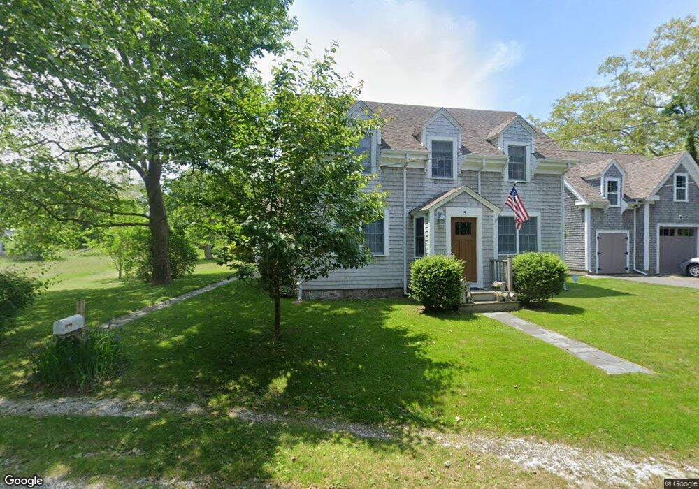
5 Dewey Ave Sandwich, MA 02563
Estimated Value: $1,015,486 - $1,142,000
4
Beds
2
Baths
2,201
Sq Ft
$489/Sq Ft
Est. Value
About This Home
This home is located at 5 Dewey Ave, Sandwich, MA 02563 and is currently estimated at $1,076,872, approximately $489 per square foot. 5 Dewey Ave is a home located in Barnstable County with nearby schools including Sandwich Middle High School, Waldorf School of Cape Cod, and Bridgeview Montessori School.
Ownership History
Date
Name
Owned For
Owner Type
Purchase Details
Closed on
Apr 26, 2002
Sold by
Prud Res Serv Lp
Bought by
Mckenna Michael R and Mckenna Susan M
Current Estimated Value
Purchase Details
Closed on
Jun 25, 1998
Sold by
Cushman Robert L and Smith Gail M
Bought by
Hodge Douglas S and Lassen Kristine D
Purchase Details
Closed on
Oct 27, 1989
Sold by
Sullivan Ann C
Bought by
Cushman Robert L
Create a Home Valuation Report for This Property
The Home Valuation Report is an in-depth analysis detailing your home's value as well as a comparison with similar homes in the area
Purchase History
We collect this data history from publicly available records. To have your information removed, we recommend requesting removal directly through your county’s website.
| Date | Buyer | Sale Price | Title Company |
|---|---|---|---|
| Mckenna Michael R | $359,000 | -- | |
| Prud Res Serv Ltd Ptn | $359,000 | -- | |
| Hodge Douglas S | $220,000 | -- | |
| Cushman Robert L | $133,500 | -- |
Source: Public Records
Mortgage History
We collect this data history from publicly available records. To have your information removed, we recommend requesting removal directly through your county’s website.
| Date | Status | Borrower | Loan Amount |
|---|---|---|---|
| Open | Cushman Robert L | $200,000 | |
| Closed | Cushman Robert L | $192,000 | |
| Closed | Cushman Robert L | $192,000 |
Source: Public Records
Tax History
| Year | Tax Paid | Tax Assessment Tax Assessment Total Assessment is a certain percentage of the fair market value that is determined by local assessors to be the total taxable value of land and additions on the property. | Land | Improvement |
|---|---|---|---|---|
| 2025 | $9,817 | $928,800 | $409,100 | $519,700 |
| 2024 | $9,398 | $870,200 | $365,300 | $504,900 |
| 2023 | $8,288 | $720,700 | $252,400 | $468,300 |
| 2022 | $7,737 | $587,900 | $201,600 | $386,300 |
| 2021 | $3,425 | $543,400 | $193,800 | $349,600 |
| 2020 | $7,692 | $537,500 | $206,100 | $331,400 |
| 2019 | $8,578 | $512,900 | $202,300 | $310,600 |
| 2018 | $2,988 | $484,000 | $195,300 | $288,700 |
| 2017 | $8,249 | $484,000 | $214,600 | $269,400 |
| 2016 | $6,799 | $469,900 | $207,300 | $262,600 |
| 2015 | $6,586 | $444,400 | $186,800 | $257,600 |
Source: Public Records
Map
Nearby Homes
Your Personal Tour Guide
Ask me questions while you tour the home.