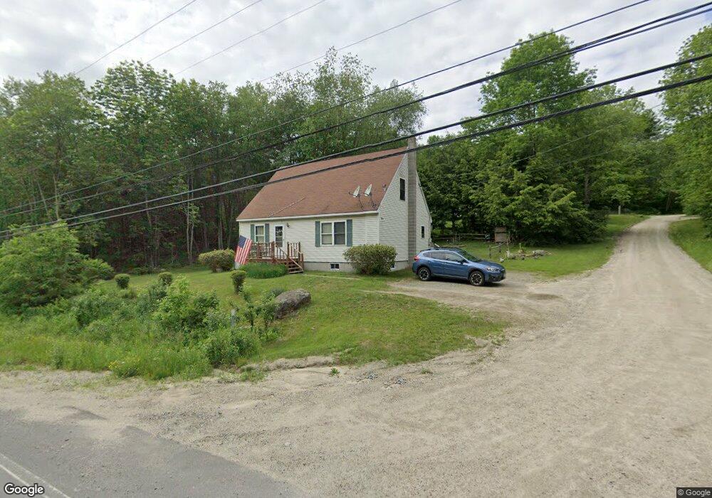
5 Doe Rd Stoddard, NH 03464
Estimated Value: $289,446 - $368,000
3
Beds
1
Bath
1,428
Sq Ft
$221/Sq Ft
Est. Value
About This Home
This home is located at 5 Doe Rd, Stoddard, NH 03464 and is currently estimated at $315,862, approximately $221 per square foot. 5 Doe Rd is a home with nearby schools including James Faulkner Elementary School, Keene High School, and Kroka Expeditions.
Ownership History
Date
Name
Owned For
Owner Type
Purchase Details
Closed on
Mar 8, 2013
Sold by
Bunker Daniel W
Bought by
Bunker Bethany D
Current Estimated Value
Home Financials for this Owner
Home Financials are based on the most recent Mortgage that was taken out on this home.
Original Mortgage
$59,000
Outstanding Balance
$41,465
Interest Rate
3.45%
Mortgage Type
Purchase Money Mortgage
Estimated Equity
$274,397
Create a Home Valuation Report for This Property
The Home Valuation Report is an in-depth analysis detailing your home's value as well as a comparison with similar homes in the area
Purchase History
| Date | Buyer | Sale Price | Title Company |
|---|---|---|---|
| Bunker Bethany D | -- | -- |
Source: Public Records
Mortgage History
| Date | Status | Borrower | Loan Amount |
|---|---|---|---|
| Open | Bunker Bethany D | $59,000 |
Source: Public Records
Tax History
| Year | Tax Paid | Tax Assessment Tax Assessment Total Assessment is a certain percentage of the fair market value that is determined by local assessors to be the total taxable value of land and additions on the property. | Land | Improvement |
|---|---|---|---|---|
| 2024 | $2,217 | $188,500 | $55,000 | $133,500 |
| 2023 | $2,759 | $162,490 | $30,000 | $132,490 |
| 2022 | $2,653 | $162,490 | $30,000 | $132,490 |
| 2021 | $2,692 | $162,490 | $30,000 | $132,490 |
| 2020 | $2,666 | $162,490 | $30,000 | $132,490 |
| 2019 | $2,454 | $162,490 | $30,000 | $132,490 |
| 2018 | $2,148 | $125,780 | $20,000 | $105,780 |
| 2016 | $1,885 | $125,780 | $20,000 | $105,780 |
| 2014 | $2,001 | $125,780 | $20,000 | $105,780 |
| 2013 | $2,313 | $146,970 | $40,000 | $106,970 |
Source: Public Records
Map
Nearby Homes
- 172 Nh-Rte 123 Route
- 14 Hammann Dr
- 0 Old Marlow Rd Unit 7
- 849 Route 10
- 1046 Kings Hwy
- 67 Lang Rd
- 00 Kennedy Brook Dr Unit 11
- 664 Tigola Trail
- 00 Rogers Rd Unit 5A
- 66 Taft Rd
- 0 Adams Dr
- 107-11.1 Wood Lot Ln
- 83 Jackson Dr
- 0 Presidential Dr Unit 328
- 259 Wood Lot Ln
- M10 L50 Ashuelot Dr
- 0 Valley Rd Unit 2 and 055
- 906 Shedd Hill Rd
- 1063 Shedd Hill Rd
- 0 Valley Rd Unit 9
- 3595 New Hampshire 123
- 19 Doe Rd
- 3709 Route 123 N
- 45 Doe Rd
- 3644 Route 123 N
- 3724 Route 123 N
- 71 Doe Rd
- 3760 Route 123 N
- 3780 New Hampshire 123
- 3596 Route 123 N
- 3780 Route 123 N
- 3594 Route 123 N
- 3595 Route 123 N
- 3846 Route 123 N
- 3592 Route 123 N
- 3886 Route 123 N
- 3848 Route 123 N
- 3509 Route 123 N
- 820 Queen St
- 5 Nh Route 123
Your Personal Tour Guide
Ask me questions while you tour the home.