
Seller's Agent in 2025
Hillary Birch
Compass
(781) 608-1425
1 in this area
97 Total Sales
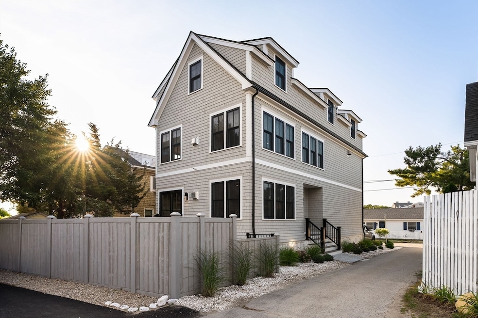


Introducing a breathtaking custom-built masterpiece on Duxbury Beach, where no expense has been spared to create a truly exceptional home. This stunning property offers an unparalleled blend of luxurious upgrades and serene coastal living, making it the perfect escape from city life or an idyllic year-round residence. The incredible kitchen is a dream, featuring built-in Thermador appliances, a spacious walk-in pantry, and a seamless flow for entertaining. Custom bathrooms throughout the home provide a spa-like retreat, showcasing the attention to detail. Additional upgrades include security cameras, Sonos sound system, Water filtration system, radiant heat floors, and efficient heat/AC mini-splits. Cozy up by one of the two gas fireplaces, and enjoy the peace of mind provided by the whole-house generator. Experience the best of coastal living in this extraordinary Duxbury Beach property, where you can unwind to the sounds of the ocean and relish in the ultimate luxury lifestyle.
| Date | Type | Sale Price | Title Company |
|---|---|---|---|
| Quit Claim Deed | $1,495,000 | -- | |
| Quit Claim Deed | $300,000 | None Available | |
| Quit Claim Deed | -- | -- | |
| Quit Claim Deed | -- | -- |
| Date | Status | Loan Amount | Loan Type |
|---|---|---|---|
| Open | $495,000 | Purchase Money Mortgage |
| Date | Event | Price | List to Sale | Price per Sq Ft |
|---|---|---|---|---|
| 09/15/2025 09/15/25 | Sold | $1,495,000 | 0.0% | $723 / Sq Ft |
| 08/17/2025 08/17/25 | Pending | -- | -- | -- |
| 08/13/2025 08/13/25 | For Sale | $1,495,000 | -- | $723 / Sq Ft |
| Year | Tax Paid | Tax Assessment Tax Assessment Total Assessment is a certain percentage of the fair market value that is determined by local assessors to be the total taxable value of land and additions on the property. | Land | Improvement |
|---|---|---|---|---|
| 2025 | $10,857 | $1,070,700 | $306,100 | $764,600 |
| 2024 | $6,934 | $689,300 | $322,900 | $366,400 |
| 2023 | $3,547 | $331,800 | $251,700 | $80,100 |
| 2022 | $3,882 | $302,300 | $232,500 | $69,800 |
| 2021 | $3,927 | $271,200 | $202,100 | $69,100 |
| 2020 | $3,527 | $240,600 | $177,700 | $62,900 |
| 2019 | $3,692 | $251,500 | $184,900 | $66,600 |
| 2018 | $4,064 | $268,100 | $184,900 | $83,200 |
| 2017 | $2,837 | $182,900 | $143,400 | $39,500 |
| 2016 | $2,844 | $182,900 | $143,400 | $39,500 |
| 2015 | $2,853 | $182,900 | $143,400 | $39,500 |
Seller's Agent in 2025
Hillary Birch
Compass
(781) 608-1425
1 in this area
97 Total Sales
G
Seller Co-Listing Agent in 2025
Gary Smyth
Compass
(617) 833-5858
1 in this area
11 Total Sales
P
Buyer's Agent in 2025
Paul Preziosi
William Raveis R.E. & Home Services
(617) 990-4857
1 in this area
8 Total Sales
Source: MLS Property Information Network (MLS PIN)
MLS Number: 73417168
APN: DUXB-000139-000939-000186
Disclaimer: Certain information contained herein is derived from information provided by parties other than Homes.com. All information provided is deemed reliable, but is not guaranteed to be accurate and should be independently verified.
![]() The property listing data and information, or the Images, set forth herein were provided to MLS Property Information Network, Inc. from third party sources, including sellers, lessors and public records, and were compiled by MLS Property Information Network, Inc. The property listing data and information, and the Images, are for the personal, non-commercial use of consumers having a good faith interest in purchasing or leasing listed properties of the type displayed to them and may not be used for any purpose other than to identify prospective properties which such consumers may have a good faith interest in purchasing or leasing. MLS Property Information Network, Inc. and its subscribers disclaim any and all representations and warranties as to the accuracy of the property listing data and information, or as to the accuracy of any of the Images, set forth herein.
The property listing data and information, or the Images, set forth herein were provided to MLS Property Information Network, Inc. from third party sources, including sellers, lessors and public records, and were compiled by MLS Property Information Network, Inc. The property listing data and information, and the Images, are for the personal, non-commercial use of consumers having a good faith interest in purchasing or leasing listed properties of the type displayed to them and may not be used for any purpose other than to identify prospective properties which such consumers may have a good faith interest in purchasing or leasing. MLS Property Information Network, Inc. and its subscribers disclaim any and all representations and warranties as to the accuracy of the property listing data and information, or as to the accuracy of any of the Images, set forth herein.
Ask me questions while you tour the home.