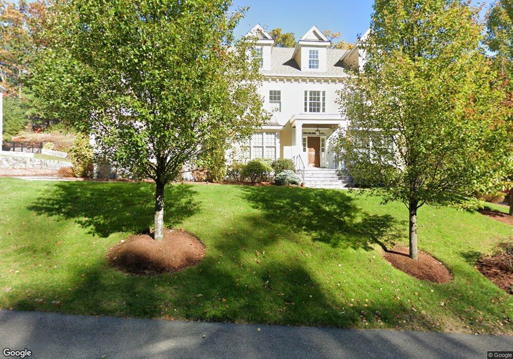
5 Kylie Ln Natick, MA 01760
Estimated Value: $1,644,000 - $2,211,000
4
Beds
5
Baths
4,917
Sq Ft
$405/Sq Ft
Est. Value
About This Home
This home is located at 5 Kylie Ln, Natick, MA 01760 and is currently estimated at $1,993,636, approximately $405 per square foot. 5 Kylie Ln is a home with nearby schools including Natick High School, J F Kennedy Middle School, and Johnson Elementary School.
Ownership History
Date
Name
Owned For
Owner Type
Purchase Details
Closed on
May 16, 2025
Sold by
Tan Howard and Tan May L
Bought by
Howard Tan Lt and Tan
Current Estimated Value
Purchase Details
Closed on
Mar 11, 2011
Sold by
Edgewater Dev Assoc In
Bought by
Tan Howard and Tan Mary L
Home Financials for this Owner
Home Financials are based on the most recent Mortgage that was taken out on this home.
Original Mortgage
$750,000
Interest Rate
4.83%
Mortgage Type
Purchase Money Mortgage
Create a Home Valuation Report for This Property
The Home Valuation Report is an in-depth analysis detailing your home's value as well as a comparison with similar homes in the area
Home Values in the Area
Average Home Value in this Area
Purchase History
| Date | Buyer | Sale Price | Title Company |
|---|---|---|---|
| Howard Tan Lt | -- | None Available | |
| Howard Tan Lt | -- | None Available | |
| Tan Howard | $1,155,550 | -- | |
| Tan Howard | $1,155,550 | -- |
Source: Public Records
Mortgage History
| Date | Status | Borrower | Loan Amount |
|---|---|---|---|
| Previous Owner | Tan Howard | $750,000 | |
| Previous Owner | Tan Howard | $825,000 |
Source: Public Records
Tax History Compared to Growth
Tax History
| Year | Tax Paid | Tax Assessment Tax Assessment Total Assessment is a certain percentage of the fair market value that is determined by local assessors to be the total taxable value of land and additions on the property. | Land | Improvement |
|---|---|---|---|---|
| 2025 | $20,208 | $1,689,600 | $488,400 | $1,201,200 |
| 2024 | $19,495 | $1,590,100 | $462,700 | $1,127,400 |
| 2023 | $17,825 | $1,410,200 | $430,600 | $979,600 |
| 2022 | $17,161 | $1,286,400 | $388,600 | $897,800 |
| 2021 | $16,676 | $1,225,300 | $383,400 | $841,900 |
| 2020 | $16,468 | $1,210,000 | $368,100 | $841,900 |
| 2019 | $15,379 | $1,210,000 | $368,100 | $841,900 |
| 2018 | $14,945 | $1,145,200 | $355,300 | $789,900 |
| 2017 | $15,109 | $1,120,000 | $344,400 | $775,600 |
| 2016 | $15,101 | $1,112,800 | $344,400 | $768,400 |
| 2015 | $14,851 | $1,074,600 | $344,400 | $730,200 |
Source: Public Records
Map
Nearby Homes
- 4 Sylvia Ave
- 26 Walden Dr Unit 4
- 46 Silver Hill Ln Unit 1
- 9 Silver Hill Ln Unit 19
- 12 Walden Dr Unit 19
- 40 Silver Hill Ln Unit 4
- 32 Silver Hill Ln Unit 1
- 91 Speen St
- 1 Fern St
- 57 Village Brook Ln Unit 5
- 50 Village Brook Ln Unit 4
- 7 Orchard View Cir Unit 7
- 51 Village Brook Ln Unit 16
- 4 Village Rock Ln Unit 9
- 6 Village Rock Ln Unit 17
- 5 Village Rock Ln Unit 24
- 1 Glen St Unit B
- 2 Lodge Rd
- 38 Ranger Rd
- 10 Kelsey Rd