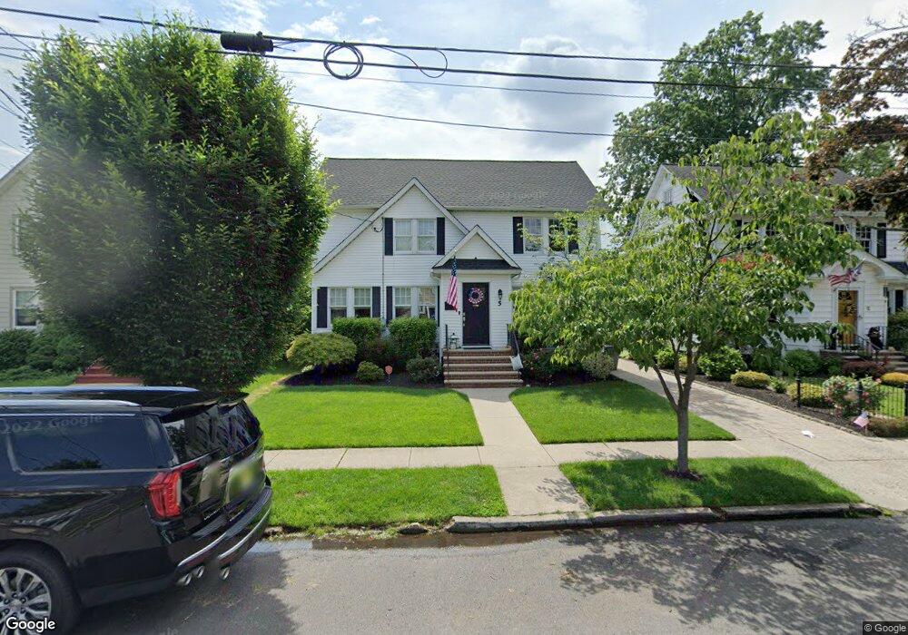
5 Lasalle Ave Cranford, NJ 07016
Estimated Value: $876,000 - $1,015,000
--
Bed
--
Bath
1,853
Sq Ft
$497/Sq Ft
Est. Value
About This Home
This home is located at 5 Lasalle Ave, Cranford, NJ 07016 and is currently estimated at $921,390, approximately $497 per square foot. 5 Lasalle Ave is a home located in Union County with nearby schools including Cranford Sr High School, St Michael School, and St. Theresa School.
Ownership History
Date
Name
Owned For
Owner Type
Purchase Details
Closed on
May 22, 2008
Sold by
Cannizzo Matthew and Cannizzo Sarah
Bought by
Golding Robert and Golding Cynthia
Current Estimated Value
Home Financials for this Owner
Home Financials are based on the most recent Mortgage that was taken out on this home.
Original Mortgage
$400,000
Outstanding Balance
$253,715
Interest Rate
5.91%
Mortgage Type
Purchase Money Mortgage
Estimated Equity
$667,675
Purchase Details
Closed on
Jun 27, 2003
Sold by
Morone Richard
Bought by
Cannizzo Matthew and Cannizzo Sarah
Home Financials for this Owner
Home Financials are based on the most recent Mortgage that was taken out on this home.
Original Mortgage
$250,000
Interest Rate
5.45%
Create a Home Valuation Report for This Property
The Home Valuation Report is an in-depth analysis detailing your home's value as well as a comparison with similar homes in the area
Home Values in the Area
Average Home Value in this Area
Purchase History
| Date | Buyer | Sale Price | Title Company |
|---|---|---|---|
| Golding Robert | $475,000 | Multiple | |
| Cannizzo Matthew | $400,000 | -- |
Source: Public Records
Mortgage History
| Date | Status | Borrower | Loan Amount |
|---|---|---|---|
| Open | Golding Robert | $400,000 | |
| Previous Owner | Cannizzo Matthew | $250,000 |
Source: Public Records
Tax History Compared to Growth
Tax History
| Year | Tax Paid | Tax Assessment Tax Assessment Total Assessment is a certain percentage of the fair market value that is determined by local assessors to be the total taxable value of land and additions on the property. | Land | Improvement |
|---|---|---|---|---|
| 2025 | $15,646 | $230,800 | $93,600 | $137,200 |
| 2024 | $15,387 | $230,800 | $93,600 | $137,200 |
| 2023 | $15,387 | $230,800 | $93,600 | $137,200 |
| 2022 | $15,261 | $230,800 | $93,600 | $137,200 |
| 2021 | $15,194 | $230,800 | $93,600 | $137,200 |
| 2020 | $15,145 | $230,800 | $93,600 | $137,200 |
| 2019 | $15,048 | $230,800 | $93,600 | $137,200 |
| 2018 | $14,456 | $225,800 | $93,600 | $132,200 |
| 2017 | $13,959 | $225,800 | $93,600 | $132,200 |
| 2016 | $11,068 | $185,800 | $93,600 | $92,200 |
| 2015 | $10,778 | $185,800 | $93,600 | $92,200 |
| 2014 | $10,557 | $185,800 | $93,600 | $92,200 |
Source: Public Records
Map
Nearby Homes