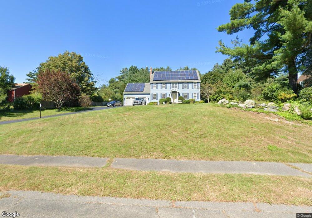
5 Lyndon Rd Wrentham, MA 02093
Estimated Value: $845,000 - $995,000
4
Beds
3
Baths
2,276
Sq Ft
$405/Sq Ft
Est. Value
About This Home
This home is located at 5 Lyndon Rd, Wrentham, MA 02093 and is currently estimated at $921,006, approximately $404 per square foot. 5 Lyndon Rd is a home located in Norfolk County with nearby schools including Delaney Elementary School, Charles E Roderick, and Foxborough Regional Charter School.
Ownership History
Date
Name
Owned For
Owner Type
Purchase Details
Closed on
Nov 23, 2020
Sold by
Lechak Edward J and Lechak Janice O
Bought by
Harper Kathryn and Dimartino Matthew
Current Estimated Value
Home Financials for this Owner
Home Financials are based on the most recent Mortgage that was taken out on this home.
Original Mortgage
$472,000
Outstanding Balance
$420,013
Interest Rate
2.8%
Mortgage Type
New Conventional
Estimated Equity
$500,993
Purchase Details
Closed on
May 26, 1995
Sold by
Born Richard C and Born Erin L
Bought by
Lechak Edward J and Lechak Janice D
Purchase Details
Closed on
Oct 20, 1994
Sold by
Joel Constr Inc
Bought by
Born Richard C and Born Erin L
Create a Home Valuation Report for This Property
The Home Valuation Report is an in-depth analysis detailing your home's value as well as a comparison with similar homes in the area
Home Values in the Area
Average Home Value in this Area
Purchase History
| Date | Buyer | Sale Price | Title Company |
|---|---|---|---|
| Harper Kathryn | $590,000 | None Available | |
| Lechak Edward J | $268,750 | -- | |
| Born Richard C | $257,295 | -- |
Source: Public Records
Mortgage History
| Date | Status | Borrower | Loan Amount |
|---|---|---|---|
| Open | Harper Kathryn | $472,000 | |
| Previous Owner | Born Richard C | $281,000 | |
| Previous Owner | Born Richard C | $275,000 | |
| Previous Owner | Born Richard C | $218,000 |
Source: Public Records
Tax History Compared to Growth
Tax History
| Year | Tax Paid | Tax Assessment Tax Assessment Total Assessment is a certain percentage of the fair market value that is determined by local assessors to be the total taxable value of land and additions on the property. | Land | Improvement |
|---|---|---|---|---|
| 2025 | $9,056 | $781,400 | $303,000 | $478,400 |
| 2024 | $8,660 | $721,700 | $303,000 | $418,700 |
| 2023 | $8,363 | $662,700 | $275,400 | $387,300 |
| 2022 | $7,979 | $583,700 | $256,900 | $326,800 |
| 2021 | $7,390 | $525,200 | $224,300 | $300,900 |
| 2020 | $7,645 | $536,500 | $199,500 | $337,000 |
| 2019 | $7,359 | $521,200 | $199,500 | $321,700 |
| 2018 | $7,207 | $506,100 | $199,800 | $306,300 |
| 2017 | $7,011 | $492,000 | $195,900 | $296,100 |
| 2016 | $6,912 | $484,000 | $190,300 | $293,700 |
| 2015 | $6,886 | $459,700 | $182,900 | $276,800 |
| 2014 | $6,556 | $428,200 | $175,900 | $252,300 |
Source: Public Records
Map
Nearby Homes
- 1 Lorraine Metcalf Dr
- 270 Dedham St
- 362 East St
- 25 Foxboro Rd
- 65 Pond St
- 10 Nature View Dr
- 15 Nature View Dr
- 10 W Birch Rd
- 0 W Birch Rd
- 3 Oak Rd
- 246 Forest Grove Ave
- 71 Pond St
- 7 Hill St Unit 10
- 20 Valley St Unit 20
- 11 Goodwin Dr
- 319 Taunton St
- 483 Thurston St
- 120 Hawes St
- 131 Creek St Unit 7
- 45 King St
- 15 Lyndon Rd
- 2 Lyndon Rd
- 25 Lyndon Rd
- 15 Charles Samuel Way
- 144 Winter St
- 20 Lyndon Rd
- 30 Lyndon Rd
- 10 Charles Samuel Way
- 98 Winter St
- 117 Winter St Unit 119
- 143 Winter St
- 113 Winter St
- 113 Winter St Unit 113
- 113 Winter St Unit 115
- 40 Lyndon Rd
- 147 Winter St
- 154 Winter St
- 9 Cee Jay Terrace
- 25 Charles Samuel Way
- 162 Winter St