Estimated Value: $566,124 - $598,000
5
Beds
3
Baths
1,536
Sq Ft
$379/Sq Ft
Est. Value
About This Home
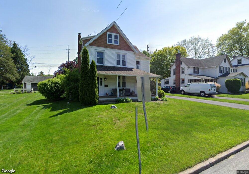
This home is located at 5 Maple Ave, Paoli, PA 19301 and is currently estimated at $582,531, approximately $379 per square foot. 5 Maple Ave is a home located in Chester County with nearby schools including Hillside Elementary School, Valley Forge Middle School, and Conestoga Senior High School.
Ownership History
Date
Name
Owned For
Owner Type
Purchase Details
Closed on
Oct 15, 1996
Sold by
Bennett Robert T
Bought by
Cropp Gerald A and Cropp Lori M
Current Estimated Value
Home Financials for this Owner
Home Financials are based on the most recent Mortgage that was taken out on this home.
Original Mortgage
$128,250
Outstanding Balance
$11,287
Interest Rate
7.62%
Estimated Equity
$571,244
Create a Home Valuation Report for This Property
The Home Valuation Report is an in-depth analysis detailing your home's value as well as a comparison with similar homes in the area
Home Values in the Area
Average Home Value in this Area
Purchase History
| Date | Buyer | Sale Price | Title Company |
|---|---|---|---|
| Cropp Gerald A | $135,000 | -- |
Source: Public Records
Mortgage History
| Date | Status | Borrower | Loan Amount |
|---|---|---|---|
| Open | Cropp Gerald A | $128,250 |
Source: Public Records
Tax History
| Year | Tax Paid | Tax Assessment Tax Assessment Total Assessment is a certain percentage of the fair market value that is determined by local assessors to be the total taxable value of land and additions on the property. | Land | Improvement |
|---|---|---|---|---|
| 2025 | $4,903 | $139,210 | $48,830 | $90,380 |
| 2024 | $4,903 | $139,210 | $48,830 | $90,380 |
| 2023 | $4,606 | $139,210 | $48,830 | $90,380 |
| 2022 | $4,487 | $139,210 | $48,830 | $90,380 |
| 2021 | $4,402 | $139,210 | $48,830 | $90,380 |
| 2020 | $4,281 | $139,210 | $48,830 | $90,380 |
| 2019 | $4,145 | $139,210 | $48,830 | $90,380 |
| 2018 | $4,063 | $139,210 | $48,830 | $90,380 |
| 2017 | $3,966 | $139,210 | $48,830 | $90,380 |
| 2016 | -- | $139,210 | $48,830 | $90,380 |
| 2015 | -- | $139,210 | $48,830 | $90,380 |
| 2014 | -- | $139,210 | $48,830 | $90,380 |
Source: Public Records
Map
Nearby Homes
- 332 Paoli Pointe Dr Unit 332U
- 104 Paoli Pointe Dr Unit 104
- 117 Woodgate Ln
- 131 Devon Rd
- 1304 Weatherstone Dr Unit 1304
- 1441 Berwyn Paoli Rd
- 1 Whitworth Ave
- 71 W Central Ave
- 1500 Sugartown Rd
- 317 Greene Rd
- 2 Martins Ln
- 26 Moreland Rd
- 36 Fairview Rd
- 69 Highpoint Dr Unit 69
- 211 Shoreline Dr
- 38 Jacqueline Dr
- 1250 Swedesford Rd
- 57 Grubb Rd
- 1304 Sugartown Rd
- 23 Grey Ct
- 3 Maple Ave
- 7 Maple Ave
- 4 Maple Ave
- 1 Maple Ave
- 9 Maple Ave
- 2 Maple Ave
- 11 Maple Ave Unit 2
- 11 Maple Ave
- 10 Maple Ave
- 13 Maple Ave
- 14 Maple Ave
- 3502 Lancaster Ave
- 16 Maple Ave
- 18 Maple Ave
- 123 E Lancaster Ave
- 17 Maple Ave
- 20 Maple Ave
- 1800 E Lancaster Ave
- 1800 E Lancaster Ave Unit F
- 1800 E Lancaster Ave Unit SUITE B
Your Personal Tour Guide
Ask me questions while you tour the home.