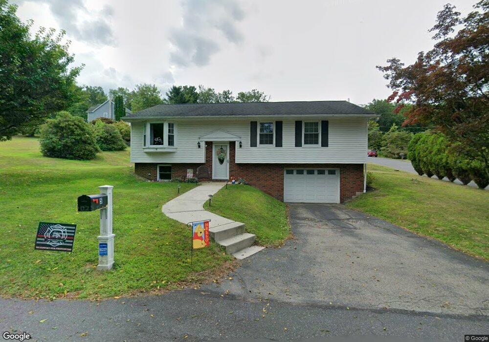
5 Maple St Ashland, PA 17921
Estimated Value: $250,000 - $327,000
3
Beds
2
Baths
1,675
Sq Ft
$165/Sq Ft
Est. Value
About This Home
This home is located at 5 Maple St, Ashland, PA 17921 and is currently estimated at $277,143, approximately $165 per square foot. 5 Maple St is a home located in Schuylkill County with nearby schools including North Schuylkill Elementary School and North Schuylkill Junior/Senior High School.
Ownership History
Date
Name
Owned For
Owner Type
Purchase Details
Closed on
Nov 1, 2024
Sold by
Scully Brian and Scully Pamela J
Bought by
Oconnell Michelle
Current Estimated Value
Home Financials for this Owner
Home Financials are based on the most recent Mortgage that was taken out on this home.
Original Mortgage
$225,000
Outstanding Balance
$222,747
Interest Rate
6.09%
Mortgage Type
New Conventional
Estimated Equity
$54,396
Purchase Details
Closed on
Jan 15, 2021
Sold by
Roshoe Gary A and Roshoe Linda J
Bought by
Scully Pamela J and Scully Brian
Purchase Details
Closed on
Jun 26, 2018
Sold by
Johnson Nicole M
Bought by
Roshoe Gary A and Roshoe Linda J
Purchase Details
Closed on
Jul 27, 2016
Sold by
Johnson John M and Johnson Nicole M
Bought by
Johnson Nicole M
Purchase Details
Closed on
Apr 27, 2010
Sold by
Nice Winn R and Nice Lori J
Bought by
Johnson John M and Johnson Nicole M
Create a Home Valuation Report for This Property
The Home Valuation Report is an in-depth analysis detailing your home's value as well as a comparison with similar homes in the area
Home Values in the Area
Average Home Value in this Area
Purchase History
| Date | Buyer | Sale Price | Title Company |
|---|---|---|---|
| Oconnell Michelle | $250,000 | None Listed On Document | |
| Scully Pamela J | -- | None Available | |
| Roshoe Gary A | $135,000 | None Available | |
| Johnson Nicole M | -- | None Available | |
| Johnson John M | $75,000 | None Available |
Source: Public Records
Mortgage History
| Date | Status | Borrower | Loan Amount |
|---|---|---|---|
| Open | Oconnell Michelle | $225,000 |
Source: Public Records
Tax History Compared to Growth
Tax History
| Year | Tax Paid | Tax Assessment Tax Assessment Total Assessment is a certain percentage of the fair market value that is determined by local assessors to be the total taxable value of land and additions on the property. | Land | Improvement |
|---|---|---|---|---|
| 2025 | $3,403 | $43,810 | $5,000 | $38,810 |
| 2024 | $3,189 | $43,810 | $5,000 | $38,810 |
| 2023 | $3,189 | $43,810 | $5,000 | $38,810 |
| 2022 | $3,118 | $43,810 | $5,000 | $38,810 |
| 2021 | $3,079 | $43,810 | $5,000 | $38,810 |
| 2020 | $3,022 | $43,810 | $5,000 | $38,810 |
| 2018 | $2,917 | $43,810 | $5,000 | $38,810 |
| 2017 | $2,843 | $43,810 | $5,000 | $38,810 |
| 2015 | -- | $43,810 | $5,000 | $38,810 |
| 2011 | -- | $43,810 | $0 | $0 |
Source: Public Records
Map
Nearby Homes
- 105 Laurel St
- New Yorker Plan at Laurel Street
- Michigan Plan at Laurel Street
- Iowa Plan at Laurel Street
- Stafford Plan at Laurel Street
- Andrew II Plan at Laurel Street
- San Diego Plan at Laurel Street
- 992 Fountain St
- 1012 Fountain St
- 132 Turnpike Rd
- 365 Preston Ave
- 384 W Main St
- 346 W Main St
- 322 W Main St
- 87 Railroad St
- 128 Preston Ave
- 35 W Ogden St
- 120 N Line St
- 308 E Main St
- 124 A St