Estimated Value: $740,000 - $885,000
2
Beds
2
Baths
1,310
Sq Ft
$610/Sq Ft
Est. Value
About This Home
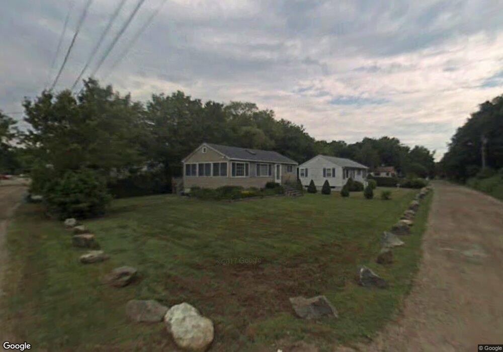
This home is located at 5 Maple St, York, ME 03909 and is currently estimated at $798,808, approximately $609 per square foot. 5 Maple St is a home located in York County with nearby schools including Coastal Ridge Elementary School, Village Elementary School, and York Middle School.
Ownership History
Date
Name
Owned For
Owner Type
Purchase Details
Closed on
Oct 3, 2017
Sold by
Seastrand Francis W Est
Bought by
Lewis Annmarie
Current Estimated Value
Home Financials for this Owner
Home Financials are based on the most recent Mortgage that was taken out on this home.
Original Mortgage
$286,800
Interest Rate
4.5%
Mortgage Type
Unknown
Purchase Details
Closed on
Jun 20, 2011
Sold by
Seastrand Francis W and Seastrand Frank
Bought by
Seastrand Francis W and Seastrand Frank
Create a Home Valuation Report for This Property
The Home Valuation Report is an in-depth analysis detailing your home's value as well as a comparison with similar homes in the area
Home Values in the Area
Average Home Value in this Area
Purchase History
| Date | Buyer | Sale Price | Title Company |
|---|---|---|---|
| Lewis Annmarie | -- | -- | |
| Seastrand Francis W | -- | -- |
Source: Public Records
Mortgage History
| Date | Status | Borrower | Loan Amount |
|---|---|---|---|
| Closed | Lewis Annmarie | $286,800 |
Source: Public Records
Tax History
| Year | Tax Paid | Tax Assessment Tax Assessment Total Assessment is a certain percentage of the fair market value that is determined by local assessors to be the total taxable value of land and additions on the property. | Land | Improvement |
|---|---|---|---|---|
| 2024 | $5,653 | $673,000 | $363,600 | $309,400 |
| 2023 | $5,382 | $636,900 | $329,000 | $307,900 |
| 2022 | $4,846 | $566,800 | $272,700 | $294,100 |
| 2021 | $4,843 | $486,700 | $238,100 | $248,600 |
| 2020 | $4,292 | $386,700 | $238,100 | $148,600 |
| 2019 | $3,955 | $354,700 | $212,100 | $142,600 |
| 2018 | $1,231 | $217,800 | $194,800 | $23,000 |
| 2017 | $3,284 | $299,900 | $194,800 | $105,100 |
| 2016 | $3,170 | $284,300 | $173,100 | $111,200 |
| 2015 | $2,807 | $255,200 | $173,100 | $82,100 |
| 2014 | $2,731 | $255,200 | $173,100 | $82,100 |
| 2013 | $2,572 | $246,600 | $164,500 | $82,100 |
Source: Public Records
Map
Nearby Homes
- 17 Blueberry Ln
- 35 Gunnison Rd
- 1 Ocean Ave Unit 306/308 Fraction 4
- 1 Ocean Ave Unit 406/408 Fraction 4
- 1 Ocean Ave Unit 414 Fraction 6
- 1 Ocean Ave Unit 210/212 Fraction 3
- 1 Ocean Ave Unit 307 Fraction 3
- 1 Ocean Ave Unit 306/308 Fraction 6
- 1 Ocean Ave Unit 402/404 Fraction 1
- 31 Ocean Ave Unit 309
- Lot A Juniper Rd
- 10 Yorke Ridge Way
- 81 Nubble Rd
- 39 Main St
- Lot A 51 Main St
- 6 Fort Hill Ave
- 6 Fort Hill Ave Unit 1
- 6 Dingle Rd Unit 4
- 6 Dingle Rd Unit 5
- 32 Bluestone Ln