
Seller's Agent in 2025
Kellie Martone
William Pitt
(203) 948-1034
58 in this area
129 Total Sales
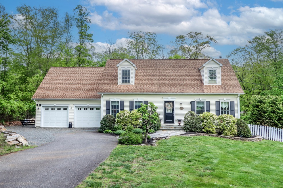
Nestled among verdant woodlands and minutes from Lake Lillinonah, this exceptional residence presents the timeless appeal of a Cape Cod amid classic New England charm. The tranquil one-acre property is bordered with mature plantings, a white picket fence, and traditional stone masonry. Step inside to discover a warm and welcoming interior with spacious rooms, abundant natural light & hardwood floors. A well-appointed kitchen features custom cabinetry, granite countertops, farmhouse sink, stainless steel appliances, breakfast bar, wine refrigerator, wood stove, and adjacent dining room. The cozy family room, full bathroom w/ tub shower, and mudroom complete the main level. Three spacious bedrooms with brand new wall-to-wall carpet and the 2nd full bathroom are located upstairs. The expansive lower level offers incredible flexibility, ready to accommodate any space you desire. Sliding glass doors bridge indoor and outdoor living. A multi-tiered deck & distinctive stone patio with a fire pit is an idyllic spot for gatherings under the stars. Additional notable features: driveway has space to accommodate boat/rv parking, storage shed, septic 2001, garage was designed for primary suite to be expanded above - Ask for details.
Last Agent to Sell the Property
William Pitt Sotheby's Int'l License #RES.0761448 Listed on: 05/13/2025
| Date | Type | Sale Price | Title Company |
|---|---|---|---|
| Warranty Deed | $650,000 | -- | |
| Warranty Deed | $650,000 | -- | |
| Warranty Deed | $412,500 | -- | |
| Warranty Deed | $412,500 | -- | |
| Warranty Deed | $85,000 | -- | |
| Warranty Deed | $85,000 | -- | |
| Deed | $180,000 | -- |
| Date | Status | Loan Amount | Loan Type |
|---|---|---|---|
| Previous Owner | $359,130 | Stand Alone Refi Refinance Of Original Loan | |
| Previous Owner | $62,500 | No Value Available |
| Date | Event | Price | List to Sale | Price per Sq Ft |
|---|---|---|---|---|
| 06/30/2025 06/30/25 | Sold | $650,000 | +4.0% | $361 / Sq Ft |
| 05/17/2025 05/17/25 | Pending | -- | -- | -- |
| 05/15/2025 05/15/25 | For Sale | $625,000 | -- | $347 / Sq Ft |
| Year | Tax Paid | Tax Assessment Tax Assessment Total Assessment is a certain percentage of the fair market value that is determined by local assessors to be the total taxable value of land and additions on the property. | Land | Improvement |
|---|---|---|---|---|
| 2025 | $8,582 | $296,660 | $95,010 | $201,650 |
| 2024 | $8,277 | $296,660 | $95,010 | $201,650 |
| 2023 | $7,968 | $296,660 | $95,010 | $201,650 |
| 2022 | $7,678 | $296,660 | $95,010 | $201,650 |
| 2021 | $7,031 | $233,590 | $105,570 | $128,020 |
| 2020 | $5,004 | $233,590 | $105,570 | $128,020 |
| 2019 | $6,807 | $233,590 | $105,570 | $128,020 |
| 2018 | $13,424 | $233,590 | $105,570 | $128,020 |
| 2017 | $6,375 | $233,590 | $105,570 | $128,020 |
| 2016 | $6,172 | $233,770 | $114,840 | $118,930 |
| 2015 | $5,805 | $225,870 | $114,840 | $111,030 |
| 2014 | $5,723 | $222,690 | $114,840 | $107,850 |
Seller's Agent in 2025
Kellie Martone
William Pitt
(203) 948-1034
58 in this area
129 Total Sales
Buyer's Agent in 2025
Diane Stevens
William Pitt
(860) 409-4108
1 in this area
18 Total Sales
Source: SmartMLS
MLS Number: 24094526
APN: BROO-000008H-000000-000069
Disclaimer: Certain information contained herein is derived from information provided by parties other than Homes.com. All information provided is deemed reliable, but is not guaranteed to be accurate and should be independently verified.
![]() IDX information is provided exclusively for personal, non-commercial use, and may not be used for any purpose other than to identify prospective properties consumers may be interested in purchasing. Information is deemed reliable but not guaranteed.
IDX information is provided exclusively for personal, non-commercial use, and may not be used for any purpose other than to identify prospective properties consumers may be interested in purchasing. Information is deemed reliable but not guaranteed.
Ask me questions while you tour the home.