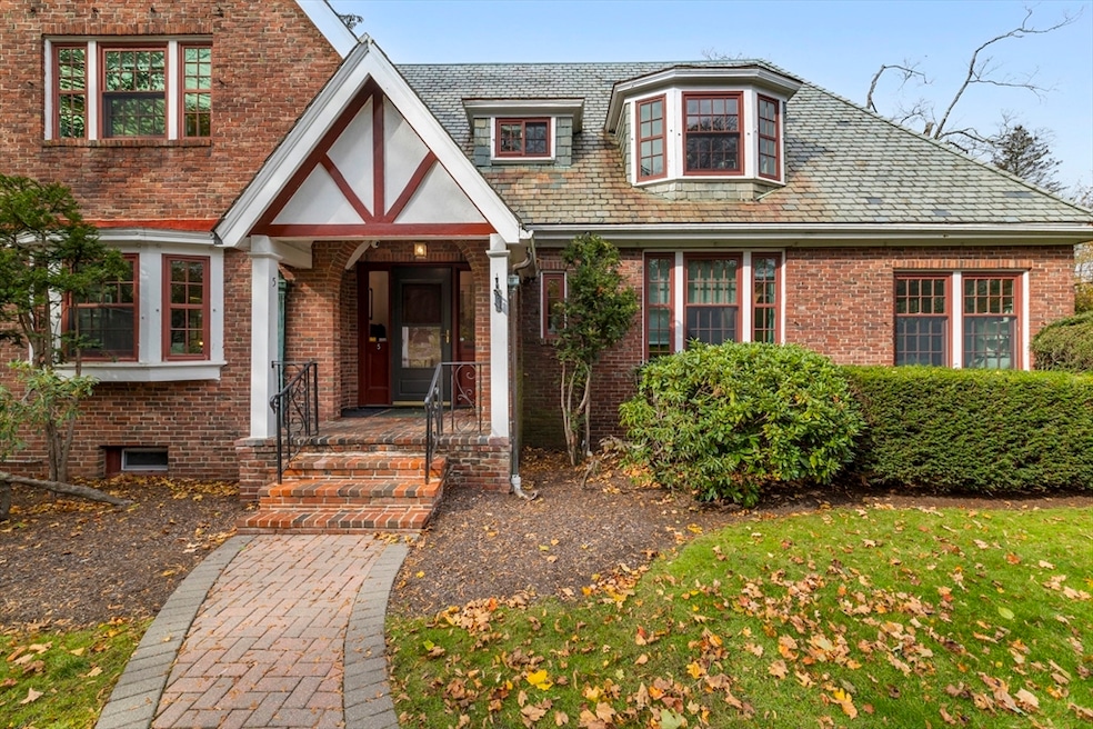
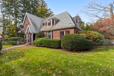
5 Merrill Rd Newton Center, MA 02459
Newton Centre NeighborhoodEstimated payment $12,785/month
Highlights
- Golf Course Community
- Medical Services
- Property is near public transit
- Ward Elementary School Rated A+
- Sauna
- Wood Flooring
About This Home
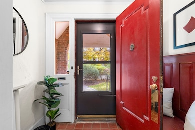
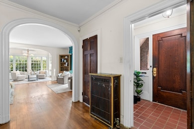
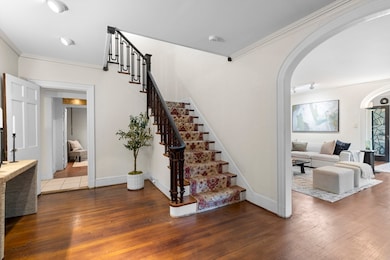
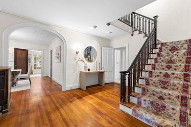
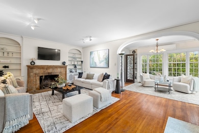
Elegant 4-bedroom, 2.5-bath Tudor ideally situated in one of Newton Centre’s most coveted locations. This cherished home offers timeless appeal, graceful flow, and abundant natural light throughout. A welcoming foyer opens to generous living and dining rooms, a charming fireplace, and a beautiful sun room overlooking a tranquil koi pond—perfect for relaxing or entertaining. While the kitchen and baths invite renovation, the home’s classic architecture and warm character provide an exquisite canvas for its next chapter. Nestled in a highly desirable neighborhood, just moments from Newton Centre’s vibrant shops, restaurants, and area synagogues, this exceptional property blends heritage, charm, and opportunity in one truly special offering. Offers if any due on Tuesday 11/11 by 2pm.
Home Details
Home Type
- Single Family
Est. Annual Taxes
- $20,600
Year Built
- Built in 1925
Lot Details
- 10,620 Sq Ft Lot
- Cul-De-Sac
- Street terminates at a dead end
- Fenced
- Level Lot
- Property is zoned SR2
Parking
- 2 Car Detached Garage
- Off-Street Parking
Home Design
- Tudor Architecture
- Slate Roof
- Concrete Perimeter Foundation
Interior Spaces
- Wet Bar
- 1 Fireplace
- Insulated Windows
- Sauna
- Wood Flooring
Kitchen
- Oven
- Freezer
- Dishwasher
- Disposal
Bedrooms and Bathrooms
- 4 Bedrooms
- Primary bedroom located on second floor
Laundry
- Dryer
- Washer
Finished Basement
- Walk-Out Basement
- Basement Fills Entire Space Under The House
- Laundry in Basement
Outdoor Features
- Enclosed Patio or Porch
Location
- Property is near public transit
- Property is near schools
Schools
- Ward Elementary School
- Bigelow Middle School
- Newton North High School
Utilities
- Ductless Heating Or Cooling System
- Whole House Fan
- Central Air
- 2 Cooling Zones
- 2 Heating Zones
- Heating System Uses Natural Gas
- Baseboard Heating
- 200+ Amp Service
- Power Generator
Listing and Financial Details
- Assessor Parcel Number S:61 B:009 L:0016,697930
Community Details
Overview
- No Home Owners Association
- Near Conservation Area
Amenities
- Medical Services
- Shops
Recreation
- Golf Course Community
- Tennis Courts
- Park
- Jogging Path
- Bike Trail
Map
Home Values in the Area
Average Home Value in this Area
Tax History
| Year | Tax Paid | Tax Assessment Tax Assessment Total Assessment is a certain percentage of the fair market value that is determined by local assessors to be the total taxable value of land and additions on the property. | Land | Improvement |
|---|---|---|---|---|
| 2025 | $20,600 | $2,102,000 | $1,681,700 | $420,300 |
| 2024 | $19,918 | $2,040,800 | $1,632,700 | $408,100 |
| 2023 | $19,262 | $1,892,100 | $1,255,300 | $636,800 |
| 2022 | $18,430 | $1,751,900 | $1,162,300 | $589,600 |
| 2021 | $17,783 | $1,652,700 | $1,096,500 | $556,200 |
| 2020 | $17,254 | $1,652,700 | $1,096,500 | $556,200 |
| 2019 | $16,768 | $1,604,600 | $1,064,600 | $540,000 |
| 2018 | $16,244 | $1,501,300 | $971,200 | $530,100 |
| 2017 | $15,749 | $1,416,300 | $916,200 | $500,100 |
| 2016 | $15,063 | $1,323,600 | $856,300 | $467,300 |
| 2015 | $14,362 | $1,237,000 | $800,300 | $436,700 |
Property History
| Date | Event | Price | List to Sale | Price per Sq Ft |
|---|---|---|---|---|
| 11/11/2025 11/11/25 | Pending | -- | -- | -- |
| 11/05/2025 11/05/25 | For Sale | $2,100,000 | -- | $539 / Sq Ft |
Purchase History
| Date | Type | Sale Price | Title Company |
|---|---|---|---|
| Quit Claim Deed | -- | None Available | |
| Quit Claim Deed | -- | None Available | |
| Personal Reps Deed | -- | -- | |
| Personal Reps Deed | -- | -- |
Source: MLS Property Information Network (MLS PIN)
MLS Number: 73451476
APN: NEWT-000061-000009-000016
Disclaimer: Certain information contained herein is derived from information provided by parties other than Homes.com. All information provided is deemed reliable, but is not guaranteed to be accurate and should be independently verified.
![]() The property listing data and information, or the Images, set forth herein were provided to MLS Property Information Network, Inc. from third party sources, including sellers, lessors and public records, and were compiled by MLS Property Information Network, Inc. The property listing data and information, and the Images, are for the personal, non-commercial use of consumers having a good faith interest in purchasing or leasing listed properties of the type displayed to them and may not be used for any purpose other than to identify prospective properties which such consumers may have a good faith interest in purchasing or leasing. MLS Property Information Network, Inc. and its subscribers disclaim any and all representations and warranties as to the accuracy of the property listing data and information, or as to the accuracy of any of the Images, set forth herein.
The property listing data and information, or the Images, set forth herein were provided to MLS Property Information Network, Inc. from third party sources, including sellers, lessors and public records, and were compiled by MLS Property Information Network, Inc. The property listing data and information, and the Images, are for the personal, non-commercial use of consumers having a good faith interest in purchasing or leasing listed properties of the type displayed to them and may not be used for any purpose other than to identify prospective properties which such consumers may have a good faith interest in purchasing or leasing. MLS Property Information Network, Inc. and its subscribers disclaim any and all representations and warranties as to the accuracy of the property listing data and information, or as to the accuracy of any of the Images, set forth herein.
- 5 Hammond St
- 209 Commonwealth Ave Unit 3E
- 104 Woodchester Dr
- 92 Grant Ave
- 23 Francis St Unit 23-1
- 21 Francis St Unit 21A
- 67 Algonquin Rd
- 9 The Ledges Rd
- 31 W Boulevard Rd
- 44 Irving St
- 27-29 Commonwealth Ave Unit 9
- 27-29 Commonwealth Ave Unit 5
- 154 Lake Shore Rd Unit 4
- 14 Lake Shore Ct Unit 1
- 116 Lake Shore Rd Unit 4
- 1004 Centre St
- 106 Farlow Rd
- 108 Lake Shore Rd Unit 4
- 145 Warren St Unit 4
- 142 Kenrick St Unit 36
