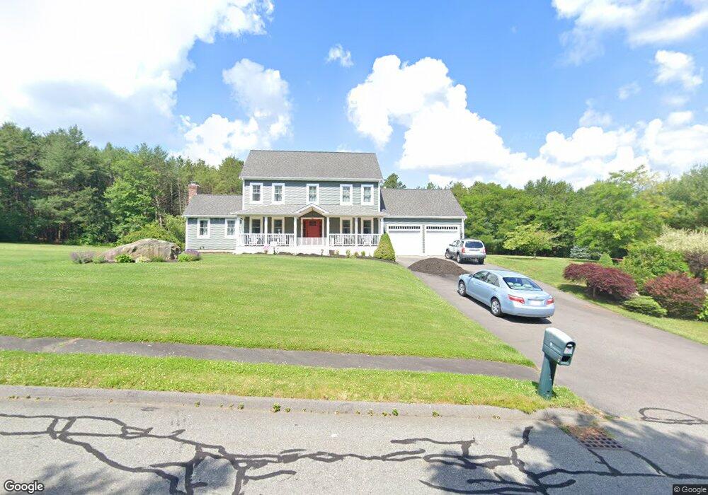
5 Mindy Ln Assonet, MA 02702
Estimated Value: $620,000 - $783,000
3
Beds
2
Baths
2,142
Sq Ft
$331/Sq Ft
Est. Value
About This Home
This home is located at 5 Mindy Ln, Assonet, MA 02702 and is currently estimated at $709,333, approximately $331 per square foot. 5 Mindy Ln is a home located in Bristol County with nearby schools including Freetown Elementary School, George R Austin Intermediate School, and Freetown-Lakeville Middle School.
Ownership History
Date
Name
Owned For
Owner Type
Purchase Details
Closed on
Jun 3, 2025
Sold by
Cabral Paula and Cabral Humberto N
Bought by
Cabral Ft and Cabral
Current Estimated Value
Purchase Details
Closed on
Apr 8, 2005
Sold by
Paul Turner Rt and Turner
Bought by
Cabral Humberto N and Cabral Paula
Home Financials for this Owner
Home Financials are based on the most recent Mortgage that was taken out on this home.
Original Mortgage
$344,925
Interest Rate
5.7%
Mortgage Type
Purchase Money Mortgage
Purchase Details
Closed on
May 26, 2004
Sold by
Assonet Land Dev Corp
Bought by
Paul Turner Rt and Turner Paul E
Create a Home Valuation Report for This Property
The Home Valuation Report is an in-depth analysis detailing your home's value as well as a comparison with similar homes in the area
Purchase History
| Date | Buyer | Sale Price | Title Company |
|---|---|---|---|
| Cabral Ft | -- | None Available | |
| Cabral Ft | -- | None Available | |
| Cabral Humberto N | $459,900 | -- | |
| Cabral Humberto N | $459,900 | -- | |
| Paul Turner Rt | $110,000 | -- |
Source: Public Records
Mortgage History
| Date | Status | Borrower | Loan Amount |
|---|---|---|---|
| Previous Owner | Paul Turner Rt | $284,000 | |
| Previous Owner | Paul Turner Rt | $342,000 | |
| Previous Owner | Cabral Humberto N | $344,925 |
Source: Public Records
Tax History
| Year | Tax Paid | Tax Assessment Tax Assessment Total Assessment is a certain percentage of the fair market value that is determined by local assessors to be the total taxable value of land and additions on the property. | Land | Improvement |
|---|---|---|---|---|
| 2025 | $6,751 | $681,200 | $198,300 | $482,900 |
| 2024 | $6,760 | $648,100 | $187,000 | $461,100 |
| 2023 | $6,654 | $621,300 | $168,500 | $452,800 |
| 2022 | $5,972 | $495,200 | $142,700 | $352,500 |
| 2021 | $5,773 | $454,600 | $129,700 | $324,900 |
| 2020 | $5,773 | $443,400 | $124,800 | $318,600 |
| 2019 | $5,559 | $422,700 | $124,400 | $298,300 |
| 2018 | $5,249 | $394,400 | $124,400 | $270,000 |
| 2017 | $5,126 | $384,800 | $124,400 | $260,400 |
| 2016 | $4,750 | $362,900 | $120,900 | $242,000 |
| 2015 | $4,585 | $355,400 | $115,400 | $240,000 |
| 2014 | $4,492 | $356,200 | $118,400 | $237,800 |
Source: Public Records
Map
Nearby Homes
- 0 Sammys Ln
- 37 Simpson Ln
- 5 Hadley Heights Way
- 16 Water St Unit C
- 16 Water St Unit A
- 16 Water St Unit B
- 16 Water St Unit D
- 52 Anthony St
- 4 Hadley Heights Way
- 42 High St
- 23 Elmwood Dr
- 73 Seymour St
- 71 County St
- 24 Bells Brook Rd
- 4 Narrows Rd
- 117 High St
- 47 Narrows Rd
- 145 County St
- 73 Bayview Ave
- 66 S Main St
Your Personal Tour Guide
Ask me questions while you tour the home.