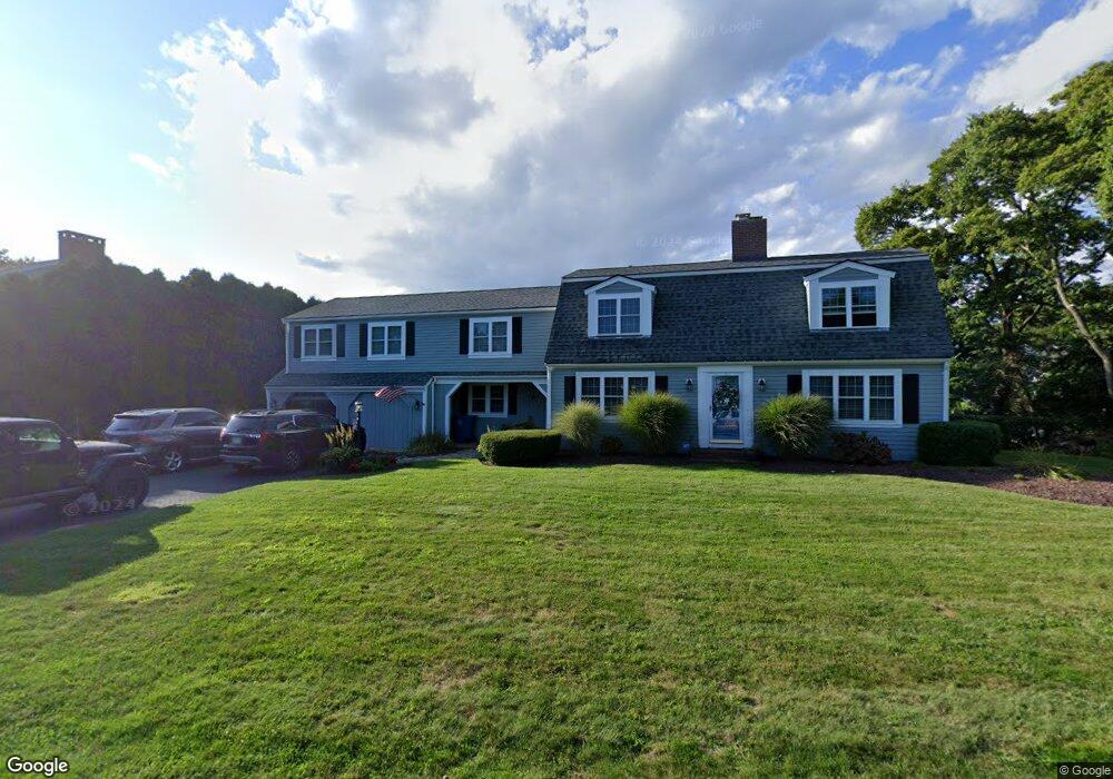
5 Pearce Place Falmouth, MA 02540
Falmouth Village NeighborhoodEstimated Value: $1,767,000 - $2,059,537
3
Beds
4
Baths
3,172
Sq Ft
$605/Sq Ft
Est. Value
About This Home
This home is located at 5 Pearce Place, Falmouth, MA 02540 and is currently estimated at $1,917,634, approximately $604 per square foot. 5 Pearce Place is a home located in Barnstable County with nearby schools including Mullen-Hall School, Lawrence School, and Morse Pond School.
Ownership History
Date
Name
Owned For
Owner Type
Purchase Details
Closed on
Nov 1, 2017
Sold by
Dicalogero Nt 2 and Dicalogero
Bought by
Timothy P Coskren Ret and Coskren
Current Estimated Value
Home Financials for this Owner
Home Financials are based on the most recent Mortgage that was taken out on this home.
Original Mortgage
$325,000
Outstanding Balance
$270,886
Interest Rate
3.83%
Mortgage Type
New Conventional
Estimated Equity
$1,646,748
Create a Home Valuation Report for This Property
The Home Valuation Report is an in-depth analysis detailing your home's value as well as a comparison with similar homes in the area
Home Values in the Area
Average Home Value in this Area
Purchase History
| Date | Buyer | Sale Price | Title Company |
|---|---|---|---|
| Timothy P Coskren Ret | $875,000 | -- |
Source: Public Records
Mortgage History
| Date | Status | Borrower | Loan Amount |
|---|---|---|---|
| Open | Timothy P Coskren Ret | $325,000 |
Source: Public Records
Tax History Compared to Growth
Tax History
| Year | Tax Paid | Tax Assessment Tax Assessment Total Assessment is a certain percentage of the fair market value that is determined by local assessors to be the total taxable value of land and additions on the property. | Land | Improvement |
|---|---|---|---|---|
| 2025 | $9,207 | $1,568,400 | $756,200 | $812,200 |
| 2024 | $8,961 | $1,426,900 | $687,500 | $739,400 |
| 2023 | $8,900 | $1,286,100 | $687,500 | $598,600 |
| 2022 | $7,734 | $960,800 | $458,900 | $501,900 |
| 2021 | $7,481 | $880,100 | $439,000 | $441,100 |
| 2020 | $7,217 | $840,200 | $399,100 | $441,100 |
| 2019 | $7,180 | $838,800 | $399,100 | $439,700 |
| 2018 | $6,813 | $783,500 | $399,100 | $384,400 |
| 2017 | $6,554 | $768,400 | $399,100 | $369,300 |
| 2016 | $6,432 | $768,400 | $399,100 | $369,300 |
| 2015 | $6,293 | $768,400 | $399,100 | $369,300 |
| 2014 | $6,024 | $739,100 | $399,100 | $340,000 |
Source: Public Records
Map
Nearby Homes
- 15 Hedge Ln
- 65 Walker St
- 71 Main St
- 98 Main St
- 98 Main St Unit 1
- 38 Landfall Unit 38
- 38 Landfall
- 30 Katherine Lee Bates Rd
- 33 Oakwood Ave
- 480 Main St Unit 1
- 87 Oyster Pond Rd
- 129 Hamlin Ave
- 110 Dillingham Ave Unit 322
- 253 Scranton Ave
- 251 Woods Hole Rd
- 9 Fairmount Ave Unit 1
- 9 Fairmount Ave
- 354 Gifford St Unit 5
- 354 Gifford St Unit 2
- 354 Gifford St Unit 6
- 15 Pearce Place
- 180 Mill Rd Unit 3
- 180 Mill Rd Unit 2
- 180 Mill Rd Unit 1
- 180 Mill Rd Unit 3A
- 180 Mill Rd
- 180 Mill Rd Unit 2A
- 150 Mill Rd
- 25 Pondlet Place Unit 4
- 25 Pondlet Place Unit 3
- 25 Pondlet Place Unit 2
- 25 Pondlet Place Unit 1
- 25 Pondlet Place
- 176 Mill Rd Unit 5
- 176 Mill Rd Unit 4
- 176 Mill Rd Unit 3
- 176 Mill Rd Unit 2
- 176 Mill Rd Unit 1
- 178 Mill Rd Unit 4
- 178 Mill Rd Unit 3