
Seller's Agent in 2025
Christopher Basile
Keller Williams Realty - Washington Township
(856) 207-1578
2 in this area
90 Total Sales
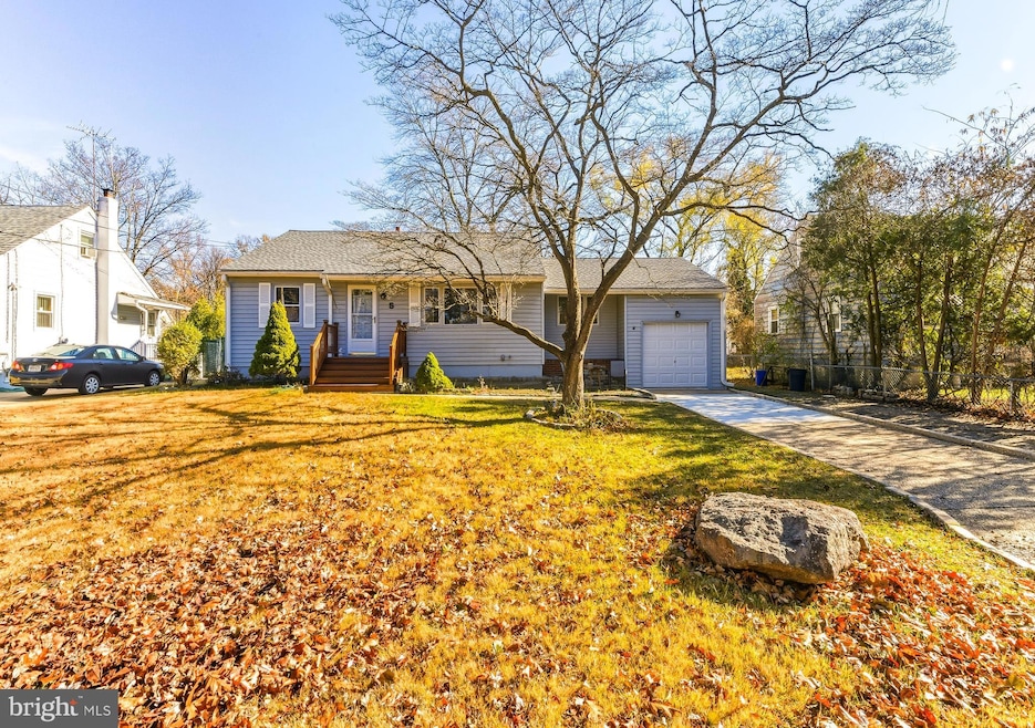
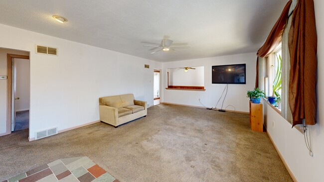

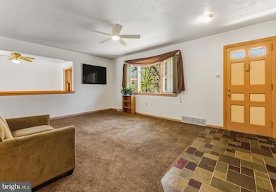

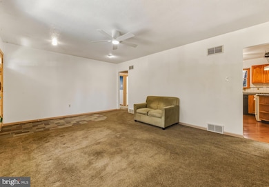

Welcome to 5 Perot Ave, a charming 2-bedroom, 1-bath rancher in the desirable east side of Cherry Hill. Built in 1950 and offering about 1,170 square feet of living space on a nicely sized 0.18-acre lot, this home blends classic character with comfort. Freshly painted throughout, the main level feels bright and inviting the moment you walk in. The home can use a modern refresh. The heart of the house is a comfortable living room that flows into the kitchen and dining areas, giving you an easy, everyday layout for cooking, relaxing, and entertaining. Downstairs, a finished basement adds valuable extra living space—ideal for a second family room, home office, gym, or playroom. You will also find the half bath on the lower level. The property is a rare find for car lovers, hobbyists, or anyone needing extra storage, thanks to both an attached garage and a separate detached shed/garage, offering multiple options for parking, projects, or a workshop. Outside, the property gives you just the right amount of yard. From the fenced backyard for gardening, pets, or summer barbecues without overwhelming maintenance. With central air and forced-air heat plus off-street parking, the home checks all the practical boxes, too. Location is a major bonus: This home sits in a quiet residential area with convenient access to the Ashland/Woodcrest PATCO stations and major commuter routes like I-295 and the White Horse Pike, making trips to Philadelphia and around South Jersey a breeze. The home is served by the highly regarded Cherry Hill school system, including nearby Horace Mann Elementary, Henry C. Beck Middle School, and Cherry Hill East High School. This is the perfect home for first-time buyers, downsizers, or anyone looking for a well-cared-for rancher in an ultra-convenient Cherry Hill location.
Last Agent to Sell the Property
(856) 582-1200 Cbasile@kw.com Keller Williams Realty - Washington Township License #RS365765 Listed on: 11/29/2025
Last Buyer's Agent
(856) 316-1100 klrw984@kw.com Keller Williams Realty - Moorestown License #1646832
| Date | Type | Sale Price | Title Company |
|---|---|---|---|
| Deed | $330,000 | Your Hometown Title | |
| Deed | $98,500 | -- |
| Date | Status | Loan Amount | Loan Type |
|---|---|---|---|
| Open | $297,000 | New Conventional | |
| Previous Owner | $98,000 | FHA |
| Date | Event | Price | List to Sale | Price per Sq Ft |
|---|---|---|---|---|
| 12/30/2025 12/30/25 | Sold | $330,000 | +3.1% | $282 / Sq Ft |
| 12/08/2025 12/08/25 | Pending | -- | -- | -- |
| 11/29/2025 11/29/25 | For Sale | $320,000 | -- | $274 / Sq Ft |
| Year | Tax Paid | Tax Assessment Tax Assessment Total Assessment is a certain percentage of the fair market value that is determined by local assessors to be the total taxable value of land and additions on the property. | Land | Improvement |
|---|---|---|---|---|
| 2025 | $6,903 | $154,800 | $51,200 | $103,600 |
| 2024 | $6,505 | $154,800 | $51,200 | $103,600 |
| 2023 | $6,505 | $154,800 | $51,200 | $103,600 |
| 2022 | $6,325 | $154,800 | $51,200 | $103,600 |
| 2021 | $6,345 | $154,800 | $51,200 | $103,600 |
| 2020 | $6,268 | $154,800 | $51,200 | $103,600 |
| 2019 | $6,265 | $154,800 | $51,200 | $103,600 |
| 2018 | $6,248 | $154,800 | $51,200 | $103,600 |
| 2017 | $6,163 | $154,800 | $51,200 | $103,600 |
| 2016 | $6,081 | $154,800 | $51,200 | $103,600 |
| 2015 | $5,985 | $154,800 | $51,200 | $103,600 |
| 2014 | $5,918 | $154,800 | $51,200 | $103,600 |
Seller's Agent in 2025
Christopher Basile
Keller Williams Realty - Washington Township
(856) 207-1578
2 in this area
90 Total Sales
Buyer's Agent in 2025
Alexandra DiFilippo
Keller Williams Realty - Moorestown
(856) 298-9699
14 in this area
150 Total Sales
Source: Bright MLS
MLS Number: NJCD2106284
APN: 09-00577-01-00017
Disclaimer: Certain information contained herein is derived from information provided by parties other than Homes.com. All information provided is deemed reliable, but is not guaranteed to be accurate and should be independently verified.
![]() The data relating to real estate for sale on this website appears in part through the BRIGHT Internet Data Exchange program, a voluntary cooperative exchange of property listing data between licensed real estate brokerage firms, and is provided by BRIGHT through a licensing agreement.
The data relating to real estate for sale on this website appears in part through the BRIGHT Internet Data Exchange program, a voluntary cooperative exchange of property listing data between licensed real estate brokerage firms, and is provided by BRIGHT through a licensing agreement.
Listing information is from various brokers who participate in the Bright MLS IDX program and not all listings may be visible on the site.
The property information being provided on or through the website is for the personal, non-commercial use of consumers and such information may not be used for any purpose other than to identify prospective properties consumers may be interested in purchasing.
Some properties which appear for sale on the website may no longer be available because they are for instance, under contract, sold or are no longer being offered for sale.
Property information displayed is deemed reliable but is not guaranteed.
Copyright 2026 Bright MLS, Inc.
Ask me questions while you tour the home.