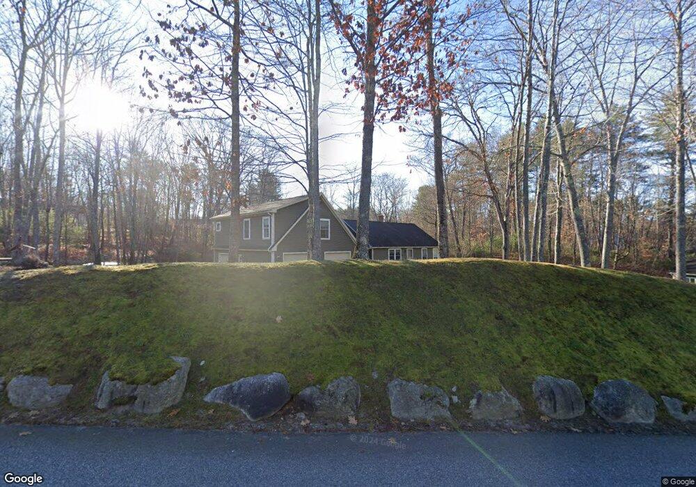
5 Quinn Rd Windham, ME 04062
Estimated Value: $595,000 - $662,000
3
Beds
3
Baths
2,196
Sq Ft
$289/Sq Ft
Est. Value
About This Home
This home is located at 5 Quinn Rd, Windham, ME 04062 and is currently estimated at $634,286, approximately $288 per square foot. 5 Quinn Rd is a home located in Cumberland County with nearby schools including Manchester School, Windham Primary School, and Windham Middle School.
Ownership History
Date
Name
Owned For
Owner Type
Purchase Details
Closed on
Mar 9, 2021
Sold by
Whitaker Marc W
Bought by
Whitaker Marc W and Whitaker Heather M
Current Estimated Value
Home Financials for this Owner
Home Financials are based on the most recent Mortgage that was taken out on this home.
Original Mortgage
$269,000
Outstanding Balance
$240,041
Interest Rate
2.7%
Mortgage Type
Purchase Money Mortgage
Estimated Equity
$394,245
Purchase Details
Closed on
Jun 7, 2006
Sold by
Sebago Heights Llc
Bought by
Whitaker Marc W
Purchase Details
Closed on
May 17, 2005
Sold by
Whitaker Robert L Est
Bought by
Whitaker Marc W
Create a Home Valuation Report for This Property
The Home Valuation Report is an in-depth analysis detailing your home's value as well as a comparison with similar homes in the area
Home Values in the Area
Average Home Value in this Area
Purchase History
| Date | Buyer | Sale Price | Title Company |
|---|---|---|---|
| Whitaker Marc W | -- | None Available | |
| Whitaker Marc W | -- | -- | |
| Whitaker Marc W | -- | -- |
Source: Public Records
Mortgage History
| Date | Status | Borrower | Loan Amount |
|---|---|---|---|
| Open | Whitaker Marc W | $269,000 |
Source: Public Records
Tax History Compared to Growth
Tax History
| Year | Tax Paid | Tax Assessment Tax Assessment Total Assessment is a certain percentage of the fair market value that is determined by local assessors to be the total taxable value of land and additions on the property. | Land | Improvement |
|---|---|---|---|---|
| 2024 | $6,581 | $573,800 | $142,200 | $431,600 |
| 2023 | $6,089 | $543,700 | $132,300 | $411,400 |
| 2022 | $5,617 | $483,800 | $117,400 | $366,400 |
| 2021 | $5,094 | $404,300 | $102,000 | $302,300 |
| 2020 | $5,250 | $350,000 | $89,900 | $260,100 |
| 2019 | $5,124 | $350,000 | $89,900 | $260,100 |
| 2018 | $4,899 | $322,700 | $81,200 | $241,500 |
| 2017 | $4,865 | $296,100 | $72,600 | $223,500 |
| 2016 | $4,649 | $296,100 | $72,600 | $223,500 |
| 2015 | $4,486 | $296,100 | $72,600 | $223,500 |
| 2014 | $4,197 | $296,100 | $72,600 | $223,500 |
| 2013 | -- | $296,100 | $72,600 | $223,500 |
Source: Public Records
Map
Nearby Homes
- 20 Bittersweet Way
- 24 Hillside Dr
- 18 Hillside Dr
- 107 Harvest Hill Rd
- 1 Pine Ln
- 1083 Roosevelt Trail
- 16 Peterson Rd
- lot #8 Bedrock Terrace
- 1042 Roosevelt Trail
- 99 Enterprise Dr
- 35 Webbs Mills Rd
- 7 Salmon Run
- 15 Worcester Dr
- 36 Whites Bridge Rd Unit 8
- 2 Flynn Rd
- 79 Whites Point Rd
- 7 Gore Rd
- 3 Pride Ln
- 105 Meadow Rd
- 12 Presidential View
- 0 Quinn Rd
- 0 Abrams Unit 877055
- 8 Quinn Rd
- 4 Quinn Rd
- 49 Pipeline Rd
- 12 Quinn Rd
- 45 Pipeline Rd
- 18 Harvest Hill Rd
- 15 Bittersweet Way
- 0 Pipeline Rd
- 55 Pipeline Rd
- 11 Abrams Way
- 14 ( Lot 10) Harvest Hill
- 14 Harvest Hill Rd
- 21 Bittersweet Way
- 41 Pipeline Rd
- 19 Harvest Hill Rd
- 50 Pipeline Rd
- 23 Colonial Park Dr
- 46 Pipeline Rd