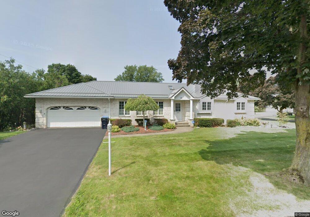
5 Ridge Port Cir Rochester, NY 14617
Estimated Value: $292,000 - $301,000
3
Beds
3
Baths
1,512
Sq Ft
$195/Sq Ft
Est. Value
About This Home
This home is located at 5 Ridge Port Cir, Rochester, NY 14617 and is currently estimated at $295,275, approximately $195 per square foot. 5 Ridge Port Cir is a home located in Monroe County with nearby schools including East Irondequoit Middle School, Eastridge Senior High School, and Archangel School.
Ownership History
Date
Name
Owned For
Owner Type
Purchase Details
Closed on
Apr 23, 2021
Sold by
Vitulli Domenick
Bought by
Hall Rosemary and Perez Luis
Current Estimated Value
Purchase Details
Closed on
May 23, 2012
Sold by
Mort John and Mazzola Linda
Bought by
Vitulli Domenick
Purchase Details
Closed on
Feb 11, 2010
Sold by
Mort Albert R and Mort Theresa H
Bought by
Mort John and Mazzola Linda
Purchase Details
Closed on
Apr 14, 2000
Sold by
Philip Siragusa
Bought by
Mort Albert R
Create a Home Valuation Report for This Property
The Home Valuation Report is an in-depth analysis detailing your home's value as well as a comparison with similar homes in the area
Home Values in the Area
Average Home Value in this Area
Purchase History
| Date | Buyer | Sale Price | Title Company |
|---|---|---|---|
| Hall Rosemary | $210,000 | Stewart Title Insurance Co | |
| Vitulli Domenick | $137,900 | None Available | |
| Mort John | -- | None Available | |
| Mort Albert R | $90,000 | -- |
Source: Public Records
Tax History Compared to Growth
Tax History
| Year | Tax Paid | Tax Assessment Tax Assessment Total Assessment is a certain percentage of the fair market value that is determined by local assessors to be the total taxable value of land and additions on the property. | Land | Improvement |
|---|---|---|---|---|
| 2024 | $8,682 | $220,000 | $17,000 | $203,000 |
| 2023 | $8,729 | $235,000 | $17,000 | $218,000 |
| 2022 | $7,400 | $147,000 | $16,500 | $130,500 |
| 2021 | $7,332 | $137,000 | $16,500 | $120,500 |
| 2020 | $6,281 | $137,000 | $16,500 | $120,500 |
| 2019 | $6,236 | $137,000 | $16,500 | $120,500 |
| 2018 | $5,971 | $137,000 | $16,500 | $120,500 |
| 2017 | $3,264 | $135,000 | $22,700 | $112,300 |
| 2016 | $6,236 | $135,000 | $22,700 | $112,300 |
| 2015 | -- | $135,000 | $22,700 | $112,300 |
| 2014 | -- | $135,000 | $22,700 | $112,300 |
Source: Public Records
Map
Nearby Homes
- 1720 Portland Ave
- 119 Twilight Dr
- 195 Kings Gate N
- 180 Kings Gate N
- 70 Kalyna Dr
- 142 Bouckhart Ave
- 105 Kalyna Dr
- 425 Norran Dr
- 130 Ellinwood Dr
- 194 Taft Ave
- 1290-1292 Portland Ave
- 429 Brookview Dr
- 155 Knapp Ave
- 456 Brookview Dr
- 109 Drake Dr
- 1482 Norton St
- 20 Parr Cir
- 41 Ridge Castle Dr
- 79 Drake Dr
- 506 Sanborn Ave
- 17 Ridge Port Cir
- 116 Ridge Port Dr
- 78 Ridge Port Dr
- 115 Ridge Port Dr
- 72 Ridge Port Dr
- 40 Ridge Port Cir
- 79 Ridge Port Dr
- 27 Ridge Port Cir
- 135 Ridge Port Dr
- 68 Ridge Port Dr
- 154 Ridge Port Dr
- 73 Ridge Port Dr
- 50 Ridge Port Cir
- 37 Ridge Port Cir
- 164 Ridge Port Dr
- 64 Ridge Port Dr
- 30 Ridge Port Dr
- 143 Ridge Port Dr
- 58 John Jay Dr
- 68 John Jay Dr