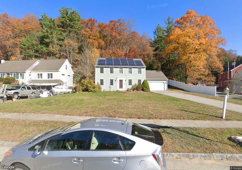
5 Tuxbury Ln Amesbury, MA 01913
Estimated Value: $748,000 - $847,000
3
Beds
2
Baths
1,728
Sq Ft
$457/Sq Ft
Est. Value
About This Home
This home is located at 5 Tuxbury Ln, Amesbury, MA 01913 and is currently estimated at $790,362, approximately $457 per square foot. 5 Tuxbury Ln is a home located in Essex County with nearby schools including Amesbury High School and Amesbury Seventh-Day Adventist School.
Ownership History
Date
Name
Owned For
Owner Type
Purchase Details
Closed on
Jan 25, 2019
Sold by
Meagher Edward D and Meagher Jennifer W
Bought by
Meagher Edward D
Current Estimated Value
Purchase Details
Closed on
Jan 14, 2005
Sold by
Mangan John F and Mangan Linnea J
Bought by
Meagher Edward D and Meagher Jennifer W
Home Financials for this Owner
Home Financials are based on the most recent Mortgage that was taken out on this home.
Original Mortgage
$312,000
Interest Rate
5.81%
Mortgage Type
Purchase Money Mortgage
Purchase Details
Closed on
Jun 17, 1994
Sold by
Rycon Rt and Noon
Bought by
Mangan John F and Mangan Linnea J
Create a Home Valuation Report for This Property
The Home Valuation Report is an in-depth analysis detailing your home's value as well as a comparison with similar homes in the area
Home Values in the Area
Average Home Value in this Area
Purchase History
| Date | Buyer | Sale Price | Title Company |
|---|---|---|---|
| Meagher Edward D | -- | -- | |
| Meagher Edward D | $392,000 | -- | |
| Mangan John F | $155,000 | -- |
Source: Public Records
Mortgage History
| Date | Status | Borrower | Loan Amount |
|---|---|---|---|
| Previous Owner | Mangan John F | $300,000 | |
| Previous Owner | Mangan John F | $312,000 | |
| Previous Owner | Mangan John F | $20,000 |
Source: Public Records
Tax History Compared to Growth
Tax History
| Year | Tax Paid | Tax Assessment Tax Assessment Total Assessment is a certain percentage of the fair market value that is determined by local assessors to be the total taxable value of land and additions on the property. | Land | Improvement |
|---|---|---|---|---|
| 2025 | $10,058 | $657,400 | $270,100 | $387,300 |
| 2024 | $9,811 | $627,300 | $254,900 | $372,400 |
| 2023 | $8,962 | $548,500 | $221,800 | $326,700 |
| 2022 | $8,564 | $484,100 | $193,200 | $290,900 |
| 2021 | $8,032 | $440,100 | $156,100 | $284,000 |
| 2020 | $7,130 | $415,000 | $150,200 | $264,800 |
| 2019 | $7,416 | $403,700 | $150,200 | $253,500 |
| 2018 | $7,131 | $375,500 | $143,100 | $232,400 |
| 2017 | $7,324 | $367,100 | $143,100 | $224,000 |
| 2016 | $7,297 | $359,800 | $143,100 | $216,700 |
| 2015 | $7,166 | $348,900 | $143,100 | $205,800 |
| 2014 | $6,996 | $333,600 | $143,100 | $190,500 |
Source: Public Records
Map
Nearby Homes
- 1 Tuxbury Ln
- 152 Kimball Rd
- 2 Alnette Rd
- 3 Greystone Rd
- 4 Acadia Kimball Rd
- 1 Acadia Kimball Rd Unit 1
- 21 Currier St
- 20 Mason Ct
- 10 Mason Ct Unit 10
- 22 Jewell St
- 8 Old County Rd
- 4 Woodsom Dr
- 188 Lions Mouth Rd
- 16 Glen Devin St
- 5 Moncrief St Unit 5
- 160 Haverhill Rd
- 10 Sharon Cir
- 3 B St
- 18 Harriman Rd
- 7 Ashley Ln