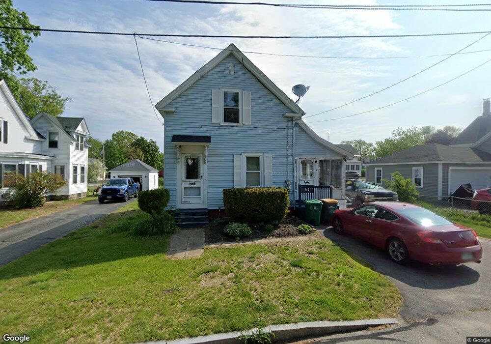
5 Unity St Rochester, NH 03868
Estimated Value: $326,478 - $376,000
3
Beds
2
Baths
1,269
Sq Ft
$274/Sq Ft
Est. Value
About This Home
This home is located at 5 Unity St, Rochester, NH 03868 and is currently estimated at $347,620, approximately $273 per square foot. 5 Unity St is a home located in Strafford County with nearby schools including East Rochester School, Nancy Loud School, and Rochester Middle School.
Ownership History
Date
Name
Owned For
Owner Type
Purchase Details
Closed on
Mar 9, 2015
Sold by
Mccarn Roberta L
Bought by
Roberta L Mccarn Ret
Current Estimated Value
Purchase Details
Closed on
Aug 10, 1971
Bought by
Roberta L Mccarn Ret
Create a Home Valuation Report for This Property
The Home Valuation Report is an in-depth analysis detailing your home's value as well as a comparison with similar homes in the area
Home Values in the Area
Average Home Value in this Area
Purchase History
We collect this data history from publicly available records. To have your information removed, we recommend requesting removal directly through your county’s website.
| Date | Buyer | Sale Price | Title Company |
|---|---|---|---|
| Roberta L Mccarn Ret | -- | -- | |
| Roberta L Mccarn Ret | -- | -- |
Source: Public Records
Tax History
| Year | Tax Paid | Tax Assessment Tax Assessment Total Assessment is a certain percentage of the fair market value that is determined by local assessors to be the total taxable value of land and additions on the property. | Land | Improvement |
|---|---|---|---|---|
| 2025 | $4,041 | $264,100 | $70,200 | $193,900 |
| 2024 | $3,922 | $264,100 | $70,200 | $193,900 |
| 2023 | $3,949 | $153,400 | $41,200 | $112,200 |
| 2022 | $3,878 | $153,400 | $41,200 | $112,200 |
| 2021 | $3,781 | $153,400 | $41,200 | $112,200 |
| 2020 | $3,797 | $154,300 | $41,200 | $113,100 |
| 2019 | $3,842 | $154,300 | $41,200 | $113,100 |
| 2018 | $3,531 | $128,300 | $31,100 | $97,200 |
| 2017 | $3,378 | $128,300 | $31,100 | $97,200 |
| 2016 | $3,332 | $117,900 | $31,100 | $86,800 |
| 2015 | $3,319 | $117,900 | $31,100 | $86,800 |
| 2014 | $3,239 | $117,900 | $31,100 | $86,800 |
| 2013 | $3,448 | $130,800 | $42,800 | $88,000 |
| 2012 | $3,359 | $130,800 | $42,800 | $88,000 |
Source: Public Records
Map
Nearby Homes
- 862 Portland St
- 32 Mill St
- 27 Highland St
- 93 Bigelow Rd
- 17 Copps Dr
- 13 Copps Dr
- 15 Copps Dr
- 13 Landing Way Unit 16
- 16 Copp Dr
- 1 Landing Way Unit 12
- 14 Copp Dr
- 29 Copp Dr
- 11 Landing Way
- 487 Salmon Falls Rd
- 483 Salmon Falls Rd
- 684 Portland St
- 871 Salmon Falls Rd
- 859 Salmon Falls Rd
- 5 Sprucewood Dr
- 27 Hampshire Ave
Your Personal Tour Guide
Ask me questions while you tour the home.