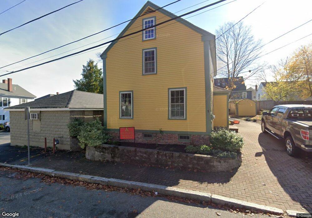
5 Warren St Newburyport, MA 01950
Estimated Value: $1,005,000 - $1,371,523
3
Beds
3
Baths
2,241
Sq Ft
$554/Sq Ft
Est. Value
About This Home
This home is located at 5 Warren St, Newburyport, MA 01950 and is currently estimated at $1,242,131, approximately $554 per square foot. 5 Warren St is a home located in Essex County with nearby schools including Francis T. Bresnahan Elementary School, Edward G. Molin Elementary School, and Rupert A. Nock Middle School.
Ownership History
Date
Name
Owned For
Owner Type
Purchase Details
Closed on
Dec 6, 2022
Sold by
Dear Kenneth E
Bought by
Kenneth Dear 2022 T
Current Estimated Value
Purchase Details
Closed on
Jun 30, 2017
Sold by
Dear Kenneth E and Pace Dominique R
Bought by
Dear Kenneth E and Pace Dominique R
Purchase Details
Closed on
Oct 23, 1986
Bought by
Dear Kenneth E
Create a Home Valuation Report for This Property
The Home Valuation Report is an in-depth analysis detailing your home's value as well as a comparison with similar homes in the area
Home Values in the Area
Average Home Value in this Area
Purchase History
| Date | Buyer | Sale Price | Title Company |
|---|---|---|---|
| Kenneth Dear 2022 T | -- | None Available | |
| Dear Kenneth E | -- | -- | |
| Dear Kenneth E | $184,000 | -- |
Source: Public Records
Mortgage History
| Date | Status | Borrower | Loan Amount |
|---|---|---|---|
| Previous Owner | Dear Kenneth E | $133,200 | |
| Previous Owner | Dear Kenneth E | $144,000 |
Source: Public Records
Tax History Compared to Growth
Tax History
| Year | Tax Paid | Tax Assessment Tax Assessment Total Assessment is a certain percentage of the fair market value that is determined by local assessors to be the total taxable value of land and additions on the property. | Land | Improvement |
|---|---|---|---|---|
| 2025 | $11,041 | $1,152,500 | $357,300 | $795,200 |
| 2024 | $10,812 | $1,084,500 | $324,800 | $759,700 |
| 2023 | $10,050 | $935,800 | $282,400 | $653,400 |
| 2022 | $9,424 | $784,700 | $235,300 | $549,400 |
| 2021 | $10,003 | $791,400 | $213,900 | $577,500 |
| 2020 | $10,162 | $791,400 | $213,900 | $577,500 |
| 2019 | $9,711 | $742,400 | $213,900 | $528,500 |
| 2018 | $9,232 | $696,200 | $203,800 | $492,400 |
| 2017 | $9,232 | $686,400 | $194,000 | $492,400 |
| 2016 | $9,390 | $701,300 | $184,800 | $516,500 |
| 2015 | $8,922 | $668,800 | $184,800 | $484,000 |
Source: Public Records
Map
Nearby Homes
- 13 Broad St
- 27 Warren St Unit 1
- 266 Merrimac St Unit F
- 288 Merrimac St
- 158 Merrimac St Unit 3
- 126 Merrimac St Unit 35
- 45 Boardman St Unit 1
- 44 Washington St Unit C
- 41 Washington St Unit B
- 14 Dexter Ln Unit B
- 14 Dexter Ln Unit A
- 58 Merrimac St Unit 2-5
- 287 1/2 High St
- 175 Bridge Rd
- 2 Court St Unit 4
- 10 10th St
- 157 Bridge Rd
- 110 Low St
- 138 Low St
- 30-32 Water St Unit 4