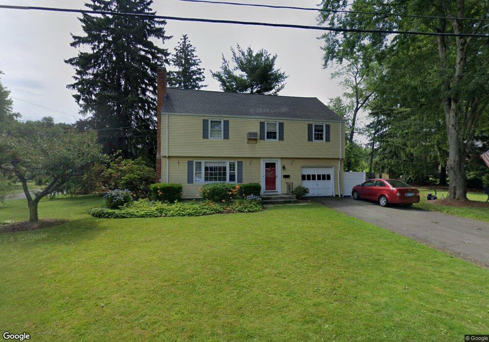
5 Westbrook Rd Bloomfield, CT 06002
Estimated Value: $379,000 - $442,000
4
Beds
2
Baths
1,788
Sq Ft
$223/Sq Ft
Est. Value
About This Home
This home is located at 5 Westbrook Rd, Bloomfield, CT 06002 and is currently estimated at $399,292, approximately $223 per square foot. 5 Westbrook Rd is a home located in Hartford County with nearby schools including Carmen Arace Intermediate School, Metacomet School, and Laurel School.
Ownership History
Date
Name
Owned For
Owner Type
Purchase Details
Closed on
May 4, 2005
Sold by
Ewing Kevin
Bought by
Heiden Nicole
Current Estimated Value
Home Financials for this Owner
Home Financials are based on the most recent Mortgage that was taken out on this home.
Original Mortgage
$193,500
Interest Rate
6.87%
Mortgage Type
Purchase Money Mortgage
Purchase Details
Closed on
Apr 26, 2002
Sold by
Gibson Julia
Bought by
Ewing Kevin
Create a Home Valuation Report for This Property
The Home Valuation Report is an in-depth analysis detailing your home's value as well as a comparison with similar homes in the area
Home Values in the Area
Average Home Value in this Area
Purchase History
| Date | Buyer | Sale Price | Title Company |
|---|---|---|---|
| Heiden Nicole | $215,000 | -- | |
| Heiden Nicole | $215,000 | -- | |
| Ewing Kevin | $185,000 | -- | |
| Ewing Kevin | $185,000 | -- |
Source: Public Records
Mortgage History
| Date | Status | Borrower | Loan Amount |
|---|---|---|---|
| Open | Ewing Kevin | $208,200 | |
| Closed | Ewing Kevin | $234,000 | |
| Closed | Ewing Kevin | $193,500 |
Source: Public Records
Tax History
| Year | Tax Paid | Tax Assessment Tax Assessment Total Assessment is a certain percentage of the fair market value that is determined by local assessors to be the total taxable value of land and additions on the property. | Land | Improvement |
|---|---|---|---|---|
| 2025 | $7,731 | $206,150 | $54,670 | $151,480 |
| 2024 | $5,472 | $139,440 | $45,850 | $93,590 |
| 2023 | $5,373 | $139,440 | $45,850 | $93,590 |
| 2022 | $5,024 | $139,440 | $45,850 | $93,590 |
| 2021 | $5,136 | $139,440 | $45,850 | $93,590 |
| 2020 | $5,056 | $139,440 | $45,850 | $93,590 |
| 2019 | $5,391 | $139,440 | $45,850 | $93,590 |
| 2018 | $4,734 | $122,570 | $41,300 | $81,270 |
| 2017 | $4,726 | $122,570 | $41,300 | $81,270 |
| 2016 | $4,615 | $122,570 | $41,300 | $81,270 |
| 2015 | $4,529 | $122,570 | $41,300 | $81,270 |
| 2014 | $4,904 | $137,200 | $48,580 | $88,620 |
Source: Public Records
Map
Nearby Homes
- 41 Timberwood Rd
- 25 Hilldale Rd
- 55 Sunny Reach Dr
- 1347 Hall Blvd
- 17 Harwich Ln Unit 17
- 40 Cottage Grove Cir
- 49 Tyler St
- 148 King Philip Dr
- 6 Spy Glass Cir
- 79 Prospect St
- 171 N Canaan St
- 165 Bloomfield Ave
- 180 Brookline Ave
- 111 Bloomfield Ave
- 153 Brewster Rd
- 256 Park Ave
- 75 Bloomfield Ave
- 69 Bloomfield Ave
- 1906 Albany Ave
- 1 King Philip Dr Unit 209
- 3 Westbrook Rd
- 29 Kenwood Cir
- 460 Bloomfield Ave
- 450 Bloomfield Ave
- 28 Kenwood Cir
- 24 Kenwood Cir
- 23 Kenwood Cir
- 31 Kenwood Cir
- 30 Kenwood Cir
- 464 Bloomfield Ave
- 444 Bloomfield Ave
- 9 Westbrook Rd
- 21 Kenwood Cir
- 440 Bloomfield Ave
- 22 Kenwood Cir
- 34 Kenwood Cir
- 470 Bloomfield Ave
- 33 Kenwood Cir
- 46 Kenwood Cir
- 19 Kenwood Cir
Your Personal Tour Guide
Ask me questions while you tour the home.