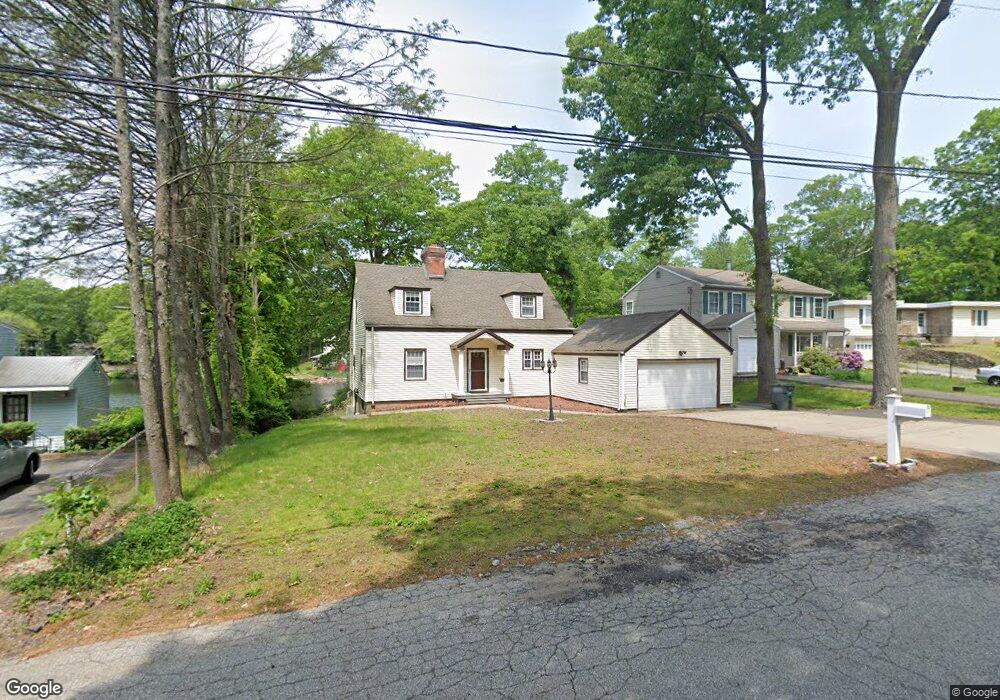
5 Wickliffe Cir Bridgeport, CT 06606
North End NeighborhoodEstimated Value: $448,000 - $554,000
2
Beds
2
Baths
1,539
Sq Ft
$320/Sq Ft
Est. Value
About This Home
This home is located at 5 Wickliffe Cir, Bridgeport, CT 06606 and is currently estimated at $492,939, approximately $320 per square foot. 5 Wickliffe Cir is a home located in Fairfield County with nearby schools including Wilbur L. Cross Elementary School, Central High School, and Northeastern Adventist Academy - Fairfield County.
Ownership History
Date
Name
Owned For
Owner Type
Purchase Details
Closed on
Apr 18, 2001
Sold by
Watson Susie E
Bought by
Helling Elizabeth S
Current Estimated Value
Home Financials for this Owner
Home Financials are based on the most recent Mortgage that was taken out on this home.
Original Mortgage
$110,000
Outstanding Balance
$40,188
Interest Rate
6.9%
Estimated Equity
$452,751
Create a Home Valuation Report for This Property
The Home Valuation Report is an in-depth analysis detailing your home's value as well as a comparison with similar homes in the area
Home Values in the Area
Average Home Value in this Area
Purchase History
| Date | Buyer | Sale Price | Title Company |
|---|---|---|---|
| Helling Elizabeth S | $209,800 | -- | |
| Helling Elizabeth S | $209,800 | -- |
Source: Public Records
Mortgage History
| Date | Status | Borrower | Loan Amount |
|---|---|---|---|
| Open | Helling Elizabeth S | $110,000 | |
| Closed | Helling Elizabeth S | $110,000 | |
| Previous Owner | Helling Elizabeth S | $120,000 |
Source: Public Records
Tax History
| Year | Tax Paid | Tax Assessment Tax Assessment Total Assessment is a certain percentage of the fair market value that is determined by local assessors to be the total taxable value of land and additions on the property. | Land | Improvement |
|---|---|---|---|---|
| 2025 | $8,298 | $190,968 | $99,698 | $91,270 |
| 2024 | $8,298 | $190,968 | $99,698 | $91,270 |
| 2023 | $8,298 | $190,968 | $99,698 | $91,270 |
| 2022 | $8,298 | $190,968 | $99,698 | $91,270 |
| 2021 | $8,298 | $190,968 | $99,698 | $91,270 |
| 2020 | $8,064 | $149,370 | $75,610 | $73,760 |
| 2019 | $8,064 | $149,370 | $75,610 | $73,760 |
| 2018 | $8,121 | $149,370 | $75,610 | $73,760 |
| 2017 | $8,121 | $149,370 | $75,610 | $73,760 |
| 2016 | $8,121 | $149,370 | $75,610 | $73,760 |
| 2015 | $7,926 | $187,830 | $85,580 | $102,250 |
| 2014 | $7,926 | $187,830 | $85,580 | $102,250 |
Source: Public Records
Map
Nearby Homes
- 1376 Chopsey Hill Rd
- 1320 Chopsey Hill Rd
- 74 Village Ln
- 563 Lakeside Dr
- 65 Clearview Dr
- 26 Karen Ct Unit A
- 82 Yaremich Dr
- 165 Yaremich Dr
- 291 Frenchtown Rd
- 26 Victory St
- 274 Platt St
- 70 Pleasantview Ave
- 365 Platt St
- 410 Alba Ave
- 495 Alba Ave
- 475 Alba Ave
- 936 Chopsey Hill Rd
- 11 Linda Dr
- 93 Oxford St Unit 95
- 85 Platt St
- 2 Wickliffe Cir
- 9 Wickliffe Cir
- 10 Wickliffe Cir
- 19 Wickliffe Cir
- 65 Lakeside Dr
- 73 Lakeside Dr
- 55 Lakeside Dr
- 1465 Chopsey Hill Rd
- 1485 Chopsey Hill Rd
- 1473 Chopsey Hill Rd
- 1451 Chopsey Hill Rd
- 1497 Chopsey Hill Rd
- 99 Lakeside Dr
- 1441 Chopsey Hill Rd
- 35 Wickliffe Cir
- 45 Lakeside Dr
- 1511 Chopsey Hill Rd
- 45 Wickliffe Cir
- 70 Lakeside Dr
- 30 Wickliffe Cir
Your Personal Tour Guide
Ask me questions while you tour the home.