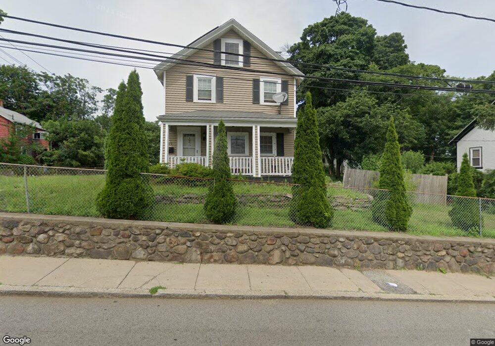
50 Fremont St Mattapan, MA 02126
Southern Mattapan NeighborhoodEstimated Value: $567,000 - $823,176
5
Beds
2
Baths
1,892
Sq Ft
$382/Sq Ft
Est. Value
About This Home
This home is located at 50 Fremont St, Mattapan, MA 02126 and is currently estimated at $722,544, approximately $381 per square foot. 50 Fremont St is a home located in Suffolk County with nearby schools including KIPP Academy Boston Charter School and Berea Seventh-day Adventist Academy.
Ownership History
Date
Name
Owned For
Owner Type
Purchase Details
Closed on
Jan 11, 1995
Sold by
Mcbee Rose N
Bought by
Kyne Ezzadale and Kyne John W
Current Estimated Value
Home Financials for this Owner
Home Financials are based on the most recent Mortgage that was taken out on this home.
Original Mortgage
$58,500
Interest Rate
9.23%
Mortgage Type
Purchase Money Mortgage
Create a Home Valuation Report for This Property
The Home Valuation Report is an in-depth analysis detailing your home's value as well as a comparison with similar homes in the area
Home Values in the Area
Average Home Value in this Area
Purchase History
| Date | Buyer | Sale Price | Title Company |
|---|---|---|---|
| Kyne Ezzadale | $65,000 | -- |
Source: Public Records
Mortgage History
| Date | Status | Borrower | Loan Amount |
|---|---|---|---|
| Open | Kyne Ezzadale | $30,000 | |
| Closed | Kyne Ezzadale | $58,500 | |
| Closed | Kyne Ezzadale | $58,500 |
Source: Public Records
Tax History Compared to Growth
Tax History
| Year | Tax Paid | Tax Assessment Tax Assessment Total Assessment is a certain percentage of the fair market value that is determined by local assessors to be the total taxable value of land and additions on the property. | Land | Improvement |
|---|---|---|---|---|
| 2025 | $8,148 | $703,600 | $283,800 | $419,800 |
| 2024 | $8,102 | $743,300 | $284,200 | $459,100 |
| 2023 | $7,390 | $688,100 | $263,100 | $425,000 |
| 2022 | $7,487 | $688,100 | $263,100 | $425,000 |
| 2021 | $6,927 | $649,200 | $248,200 | $401,000 |
| 2020 | $5,526 | $523,300 | $239,300 | $284,000 |
| 2019 | $4,927 | $467,500 | $182,600 | $284,900 |
| 2018 | $4,621 | $440,900 | $182,600 | $258,300 |
| 2017 | $4,489 | $423,900 | $182,600 | $241,300 |
| 2016 | $4,358 | $396,200 | $182,600 | $213,600 |
| 2015 | $3,810 | $314,600 | $148,900 | $165,700 |
| 2014 | $3,534 | $280,900 | $148,900 | $132,000 |
Source: Public Records
Map
Nearby Homes
- 24 Constitution Rd
- 10 Briarcliff Terrace
- 4 Crossman St Unit 4
- 11 French St
- 1465 Blue Hill Ave
- 32 Violet St
- 95 Woodhaven St
- 157 Delhi St
- 10 Brockton St
- 48-50 Rockdale St
- 12 Hiawatha Rd
- 770 Cummins Hwy Unit 1
- 770 Cummins Hwy Unit 22
- 84 Blue Hills Pkwy
- 27 Hawthorn Rd
- 333 Eliot St
- 16 Blue Hill Ave
- 567B Norfolk St
- 710 Walk Hill St
- 20 Monterey Ave
- 56 Fremont St
- 8 Faunce Rd
- 8 Faunce Rd Unit A
- 46 Fremont St Unit 48
- 46-48 Fremont St
- 11 Faunce Rd Unit 13
- 55 Fremont St
- 43-47 Fremont St Unit 14
- 43-47 Fremont St Unit 8
- 43-47 Fremont St Unit 13
- 43-47 Fremont St Unit 4
- 43-47 Fremont St Unit 11
- 43-47 Fremont St Unit 7
- 43-47 Fremont St Unit 9
- 43-47 Fremont St Unit 12
- 43-47 Fremont St Unit 10
- 43-47 Fremont St Unit 2
- 43-47 Fremont St Unit 3
- 43-47 Fremont St Unit 5
- 43-47 Fremont St