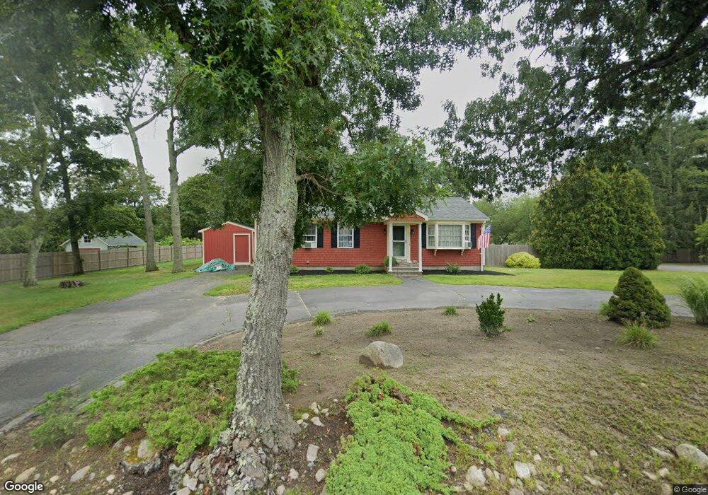
50 Gifford Rd Westport, MA 02790
North Westport NeighborhoodEstimated Value: $447,548 - $543,000
3
Beds
1
Bath
1,056
Sq Ft
$474/Sq Ft
Est. Value
About This Home
This home is located at 50 Gifford Rd, Westport, MA 02790 and is currently estimated at $500,637, approximately $474 per square foot. 50 Gifford Rd is a home located in Bristol County with nearby schools including Alice A. Macomber Primary School, Westport Elementary School, and Westport Middle-High School.
Ownership History
Date
Name
Owned For
Owner Type
Purchase Details
Closed on
Dec 10, 2004
Sold by
Smeaton Mark S and Smeaton Sheila M
Bought by
Smeaton Sheila M
Current Estimated Value
Purchase Details
Closed on
Aug 29, 1995
Sold by
Medeiros Raymond and Medeiros Honora D
Bought by
Smeaton Mark S and Smeaton Sheila S
Purchase Details
Closed on
Nov 13, 1991
Sold by
Christopher Darmaody Susan M and Christopher Darmaoy
Bought by
Medeiros Raymond and Medeiros Honora D
Create a Home Valuation Report for This Property
The Home Valuation Report is an in-depth analysis detailing your home's value as well as a comparison with similar homes in the area
Home Values in the Area
Average Home Value in this Area
Purchase History
| Date | Buyer | Sale Price | Title Company |
|---|---|---|---|
| Smeaton Sheila M | -- | -- | |
| Smeaton Mark S | $125,000 | -- | |
| Medeiros Raymond | $126,000 | -- |
Source: Public Records
Mortgage History
| Date | Status | Borrower | Loan Amount |
|---|---|---|---|
| Open | Medeiros Raymond | $236,250 | |
| Closed | Medeiros Raymond | $208,000 | |
| Previous Owner | Medeiros Raymond | $187,500 |
Source: Public Records
Tax History Compared to Growth
Tax History
| Year | Tax Paid | Tax Assessment Tax Assessment Total Assessment is a certain percentage of the fair market value that is determined by local assessors to be the total taxable value of land and additions on the property. | Land | Improvement |
|---|---|---|---|---|
| 2025 | $2,576 | $345,800 | $177,900 | $167,900 |
| 2024 | $2,501 | $323,500 | $157,900 | $165,600 |
| 2023 | $2,420 | $296,600 | $143,900 | $152,700 |
| 2022 | $2,322 | $273,800 | $143,900 | $129,900 |
| 2021 | $2,145 | $248,800 | $118,900 | $129,900 |
| 2020 | $2,058 | $244,100 | $114,200 | $129,900 |
| 2019 | $1,998 | $241,600 | $114,200 | $127,400 |
| 2018 | $2,546 | $224,800 | $114,200 | $110,600 |
| 2017 | $1,745 | $218,900 | $110,500 | $108,400 |
| 2016 | $1,624 | $205,300 | $106,900 | $98,400 |
| 2015 | $1,561 | $196,900 | $109,300 | $87,600 |
Source: Public Records
Map
Nearby Homes
- 20 Faulkner St
- 116 Gifford Rd
- 9 Kyle Jacob Rd
- 100 D Dr
- 0 Van Buren St
- 15 S Breault St
- 3 Diane Way
- 16 S Berryman St
- 9 Register Ave
- 565 Highland Ave
- 92 Benoit St
- 1276 Old Fall River Rd
- 33 William St
- 6 Beaulieu St
- 25 Beaulieu St
- 771 Sanford Rd
- 27 Dias Ave
- 19 Charles Joseph Dr
- 2 Donna Marie Dr
- 128 Old Bedford Rd