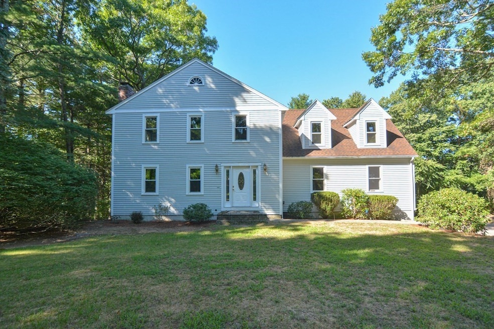
50 Heather Ln Wrentham, MA 02093
West Wrentham NeighborhoodEstimated payment $4,667/month
Highlights
- Very Popular Property
- 2.99 Acre Lot
- Deck
- Delaney Elementary School Rated A
- Colonial Architecture
- Property is near public transit
About This Home
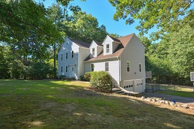
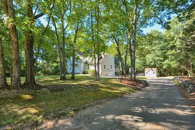
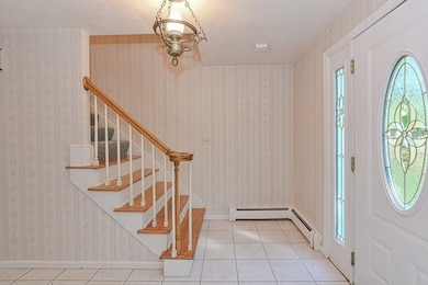
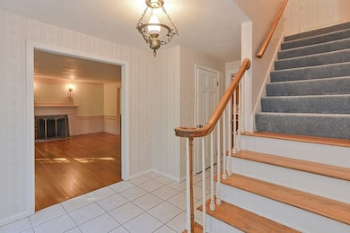
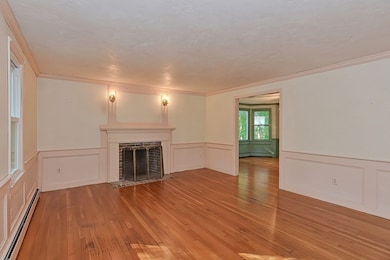
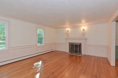
Location Location Location..........The ultimate location for this spacious colonial located on a wooded, cul-de-sac neighborhood. The whole inside of the home is yours to make with your upgrades. The kitchen has plenty of cabinets, counter space and large area for kitchen table. Large family room with wood beams is perfect for creating memories and for holiday gatherings. There is an office in the basement, which is highly sought after these days. The finished part of the basement has a large room that is suitable for many options including home office, extra family room, kids play area, pool table or home gym. Relax and entertain on the deck or backyard. Home for the Holidays!
Listing Agent
Berkshire Hathaway HomeServices Evolution Properties Listed on: 11/12/2025

Home Details
Home Type
- Single Family
Est. Annual Taxes
- $8,485
Year Built
- Built in 1987
Lot Details
- 2.99 Acre Lot
- Cul-De-Sac
- Fenced Yard
- Wooded Lot
- Property is zoned R-87
Parking
- 2 Car Attached Garage
- Tuck Under Parking
- Driveway
- Open Parking
Home Design
- Colonial Architecture
- Frame Construction
- Shingle Roof
- Concrete Perimeter Foundation
Interior Spaces
- 2,624 Sq Ft Home
- Sliding Doors
- Family Room with Fireplace
- 2 Fireplaces
- Living Room with Fireplace
- Bonus Room
- Partially Finished Basement
- Basement Fills Entire Space Under The House
- Attic
Kitchen
- Range
- Microwave
- Dishwasher
Flooring
- Wood
- Wall to Wall Carpet
- Laminate
- Ceramic Tile
Bedrooms and Bathrooms
- 4 Bedrooms
- Primary bedroom located on second floor
- Bathtub with Shower
Laundry
- Laundry on main level
- Washer and Electric Dryer Hookup
Outdoor Features
- Balcony
- Deck
- Porch
Location
- Property is near public transit
- Property is near schools
Schools
- Delaneyroderick Elementary School
- King Philip Middle School
- King Philip High School
Utilities
- Whole House Fan
- Window Unit Cooling System
- 4 Heating Zones
- Heating System Uses Oil
- 200+ Amp Service
- Water Heater
- Private Sewer
Listing and Financial Details
- Legal Lot and Block 02 / 03
- Assessor Parcel Number 293753
Community Details
Overview
- No Home Owners Association
- Near Conservation Area
Amenities
- Shops
Recreation
- Tennis Courts
- Jogging Path
Map
Home Values in the Area
Average Home Value in this Area
Tax History
| Year | Tax Paid | Tax Assessment Tax Assessment Total Assessment is a certain percentage of the fair market value that is determined by local assessors to be the total taxable value of land and additions on the property. | Land | Improvement |
|---|---|---|---|---|
| 2025 | $8,485 | $732,100 | $293,800 | $438,300 |
| 2024 | $8,184 | $682,000 | $293,800 | $388,200 |
| 2023 | $8,122 | $643,600 | $267,700 | $375,900 |
| 2022 | $7,933 | $580,300 | $260,900 | $319,400 |
| 2021 | $7,837 | $557,000 | $244,200 | $312,800 |
| 2020 | $7,819 | $548,700 | $187,800 | $360,900 |
| 2019 | $7,532 | $533,400 | $187,800 | $345,600 |
| 2018 | $7,419 | $521,000 | $187,600 | $333,400 |
| 2017 | $7,195 | $504,900 | $184,000 | $320,900 |
| 2016 | $7,047 | $493,500 | $178,700 | $314,800 |
| 2015 | $7,180 | $479,300 | $171,800 | $307,500 |
| 2014 | $7,070 | $461,800 | $165,300 | $296,500 |
Property History
| Date | Event | Price | List to Sale | Price per Sq Ft |
|---|---|---|---|---|
| 11/12/2025 11/12/25 | For Sale | $749,900 | -- | $286 / Sq Ft |
Purchase History
| Date | Type | Sale Price | Title Company |
|---|---|---|---|
| Leasehold Conv With Agreement Of Sale Fee Purchase Hawaii | $245,000 | -- | |
| Deed | $269,000 | -- |
Mortgage History
| Date | Status | Loan Amount | Loan Type |
|---|---|---|---|
| Open | $345,500 | No Value Available | |
| Closed | $275,000 | No Value Available |
Source: MLS Property Information Network (MLS PIN)
MLS Number: 73454239
APN: WREN-000001E-000003-000002
Disclaimer: Certain information contained herein is derived from information provided by parties other than Homes.com. All information provided is deemed reliable, but is not guaranteed to be accurate and should be independently verified.
![]() The property listing data and information, or the Images, set forth herein were provided to MLS Property Information Network, Inc. from third party sources, including sellers, lessors and public records, and were compiled by MLS Property Information Network, Inc. The property listing data and information, and the Images, are for the personal, non-commercial use of consumers having a good faith interest in purchasing or leasing listed properties of the type displayed to them and may not be used for any purpose other than to identify prospective properties which such consumers may have a good faith interest in purchasing or leasing. MLS Property Information Network, Inc. and its subscribers disclaim any and all representations and warranties as to the accuracy of the property listing data and information, or as to the accuracy of any of the Images, set forth herein.
The property listing data and information, or the Images, set forth herein were provided to MLS Property Information Network, Inc. from third party sources, including sellers, lessors and public records, and were compiled by MLS Property Information Network, Inc. The property listing data and information, and the Images, are for the personal, non-commercial use of consumers having a good faith interest in purchasing or leasing listed properties of the type displayed to them and may not be used for any purpose other than to identify prospective properties which such consumers may have a good faith interest in purchasing or leasing. MLS Property Information Network, Inc. and its subscribers disclaim any and all representations and warranties as to the accuracy of the property listing data and information, or as to the accuracy of any of the Images, set forth herein.
- 39 Sumner Brown Rd
- 60 Grant Ave
- 45 Cook Rd
- 50 Wamsutta Way
- 236 Williams St
- 80 Fisher Rd Unit 50
- 80 Fisher Rd Unit 2
- 2095 West St
- 4 Evans St
- 300 Tower Hill Rd
- 4022 Diamond Hill Rd
- 180 Pine Swamp Rd
- 56 Pine Swamp Rd
- 11 Amber Dr
- 60 Tower Hill Rd
- 25 Nature View Dr
- 51 Reservoir Rd
- 20 Nature View Dr
- 9 Hannah Dr
- 80 Carriage House Ln
- 10 Independence Way
- 835 Upper Union St
- 183 Walnut Hill Rd Unit Left Side
- 260 South St Unit B
- 210 Highland Corporate Dr
- 665 Mendon Rd Unit FL2-ID1347759P
- 4 West St Unit 6
- 1037 Cass Ave
- 998 Cass Ave Unit 2
- 10-12 Spring St Unit 10
- 1371 Mendon Rd Unit 28
- 139 King St Unit 304
- 000 Confidential St
- 166 Cottage St Unit 1
- 301 Union St
- 30 South St Unit D
- 126 Division St Unit 1
- 12 Uncas Ave Unit 11
- 12 Everett St Unit 12
- 58 Manville Hill Rd Unit 58A