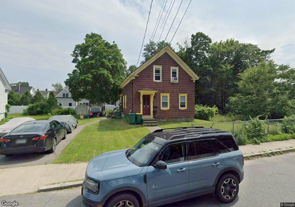
50 High St Unit 2 Mansfield, MA 02048
Estimated Value: $585,000 - $646,000
About This Home
Property Id: 399360
$1850 / 2br - 750ft - NICE AND COZY 2 BEDROOM APARTMENT (Mansfield, MA)
Available: August 15, 2025
Beautifully renovated 2 Bedroom, 1 Bath Apartment in a nice 2-family house located in a quiet yet convenient neighborhood.
Highlights:
- Hardwood/Laminate Floors
- Washer & Dryer connections available in unit
- Storage space in basement
- Near Mansfield Town Center
- 8-minute walk (0.4 mile) to Mansfield T-Station
- Easy access to I-95 and I-495
Conditions:
- No smokers, pets negotiable, cold water included in rent, tenants pay other utilities.
- Landlord takes care of landscaping.
- First and Last months rent + Security Deposit (equal to half month rent) due upon lease signing.
- Official application required. Blank application form available upon request.
- Minimum credit score of 630 to apply.
- Unit is not deleaded.
Ownership History
Purchase Details
Home Financials for this Owner
Home Financials are based on the most recent Mortgage that was taken out on this home.Purchase Details
Home Values in the Area
Average Home Value in this Area
Purchase History
| Date | Buyer | Sale Price | Title Company |
|---|---|---|---|
| Zhou Min | $374,900 | None Available | |
| Avery Robert C | $250,000 | -- |
Mortgage History
| Date | Status | Borrower | Loan Amount |
|---|---|---|---|
| Open | Zhou Min | $281,175 |
Property History
| Date | Event | Price | List to Sale | Price per Sq Ft |
|---|---|---|---|---|
| 08/25/2025 08/25/25 | Off Market | $1,850 | -- | -- |
| 08/15/2025 08/15/25 | Price Changed | $1,850 | -2.6% | $2 / Sq Ft |
| 08/10/2025 08/10/25 | For Rent | $1,900 | -- | -- |
Tax History
| Year | Tax Paid | Tax Assessment Tax Assessment Total Assessment is a certain percentage of the fair market value that is determined by local assessors to be the total taxable value of land and additions on the property. | Land | Improvement |
|---|---|---|---|---|
| 2025 | $6,347 | $481,900 | $225,100 | $256,800 |
| 2024 | $6,172 | $457,200 | $225,100 | $232,100 |
| 2023 | $6,019 | $427,200 | $225,100 | $202,100 |
| 2022 | $6,089 | $401,400 | $208,400 | $193,000 |
| 2021 | $5,616 | $365,600 | $182,400 | $183,200 |
| 2020 | $5,482 | $356,900 | $173,700 | $183,200 |
| 2019 | $4,771 | $313,500 | $144,800 | $168,700 |
| 2018 | $4,170 | $299,500 | $138,000 | $161,500 |
| 2017 | $4,006 | $266,700 | $134,000 | $132,700 |
| 2016 | $3,678 | $238,700 | $127,600 | $111,100 |
| 2015 | $3,475 | $224,200 | $127,600 | $96,600 |
Map
- 150 Rumford Ave Unit 110
- 266 N Main St Unit 3
- 28 Court St
- 22 Pleasant St Unit C
- 152 Central St
- 166 Chauncy St
- 44 Fairfield Park Unit 44
- 81 Chilson Ave
- 73-75 Draper Ave
- 46 Hope St
- 619 N Main St
- 4 Concetta Cir
- 356 Central St
- 1 Deer Path Ln
- 460 Ware St
- 571 Ware St
- 14 Windchime Dr
- 233 Central St
- 261 East St
- 4 Erick Rd Unit 90
- 50 High St
- 114 Rumford Ave
- 114 Rumford Ave Unit A
- 122 Rumford Ave Unit 2R
- 122 Rumford Ave Unit 1R
- 122 Rumford Ave Unit 2L
- 122 Rumford Ave Unit 1L
- 122 Rumford Ave
- 47 High St
- 47 High St Unit B
- 47 High St Unit A
- 47 High St Unit A-L
- 70 High St
- 43 High St Unit 101
- 43 High St Unit 103
- 43 High St Unit 102
- 43 High St Unit 1
- 43 High St
- 42 W Church St
- 106 Rumford Ave
Ask me questions while you tour the home.