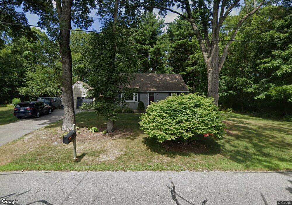
50 Lake St Seekonk, MA 02771
Estimated Value: $426,000 - $556,000
4
Beds
2
Baths
1,512
Sq Ft
$339/Sq Ft
Est. Value
About This Home
This home is located at 50 Lake St, Seekonk, MA 02771 and is currently estimated at $512,621, approximately $339 per square foot. 50 Lake St is a home located in Bristol County with nearby schools including Seekonk High School, St Margaret School, and The Wolf School.
Ownership History
Date
Name
Owned For
Owner Type
Purchase Details
Closed on
Dec 18, 2002
Sold by
Tallent Bret R and Tallent Laura L
Bought by
Langlois Jeffrey S
Current Estimated Value
Home Financials for this Owner
Home Financials are based on the most recent Mortgage that was taken out on this home.
Original Mortgage
$180,000
Outstanding Balance
$76,873
Interest Rate
6.16%
Mortgage Type
Purchase Money Mortgage
Estimated Equity
$435,748
Purchase Details
Closed on
Oct 15, 1999
Sold by
Peters Anthony and Peters Catherine
Bought by
Tallent Bret R and Tallent Laura L
Home Financials for this Owner
Home Financials are based on the most recent Mortgage that was taken out on this home.
Original Mortgage
$156,350
Interest Rate
7.8%
Mortgage Type
Purchase Money Mortgage
Create a Home Valuation Report for This Property
The Home Valuation Report is an in-depth analysis detailing your home's value as well as a comparison with similar homes in the area
Home Values in the Area
Average Home Value in this Area
Purchase History
| Date | Buyer | Sale Price | Title Company |
|---|---|---|---|
| Langlois Jeffrey S | $265,000 | -- | |
| Tallent Bret R | $156,500 | -- |
Source: Public Records
Mortgage History
| Date | Status | Borrower | Loan Amount |
|---|---|---|---|
| Open | Langlois Jeffrey S | $180,000 | |
| Previous Owner | Tallent Bret R | $350,000 | |
| Previous Owner | Tallent Bret R | $205,000 | |
| Previous Owner | Tallent Bret R | $50,000 | |
| Previous Owner | Tallent Bret R | $156,350 |
Source: Public Records
Tax History Compared to Growth
Tax History
| Year | Tax Paid | Tax Assessment Tax Assessment Total Assessment is a certain percentage of the fair market value that is determined by local assessors to be the total taxable value of land and additions on the property. | Land | Improvement |
|---|---|---|---|---|
| 2025 | $4,655 | $376,900 | $154,900 | $222,000 |
| 2024 | $4,467 | $361,700 | $154,900 | $206,800 |
| 2023 | $3,996 | $304,800 | $139,200 | $165,600 |
| 2022 | $3,699 | $277,300 | $134,900 | $142,400 |
| 2021 | $3,430 | $252,800 | $113,700 | $139,100 |
| 2020 | $3,287 | $249,600 | $113,700 | $135,900 |
| 2019 | $3,176 | $243,200 | $113,700 | $129,500 |
| 2018 | $3,124 | $234,000 | $109,600 | $124,400 |
| 2017 | $3,082 | $229,000 | $109,600 | $119,400 |
| 2016 | $3,062 | $228,300 | $109,600 | $118,700 |
| 2015 | $2,982 | $225,400 | $109,600 | $115,800 |
Source: Public Records
Map
Nearby Homes
- 824 Taunton Ave
- 25 Lincoln St
- 1078 Taunton Ave
- 9 Hidden Hills Dr
- 420 Chestnut St
- 0 Patterson St Unit 73348933
- 134 Briarbrook Dr
- 62 Chestnut St
- 463 Ledge Rd
- 442 Taunton Ave
- 524 County St
- 42 Tee Jay Dr
- 81 Salisbury St
- 181 Sherman Ave
- 268 Pine St Unit 7
- 224 Arcade Ave
- 30 Rosemarie Dr
- 349 County St
- 67 Wheeler St
- 14 Evelyn Way