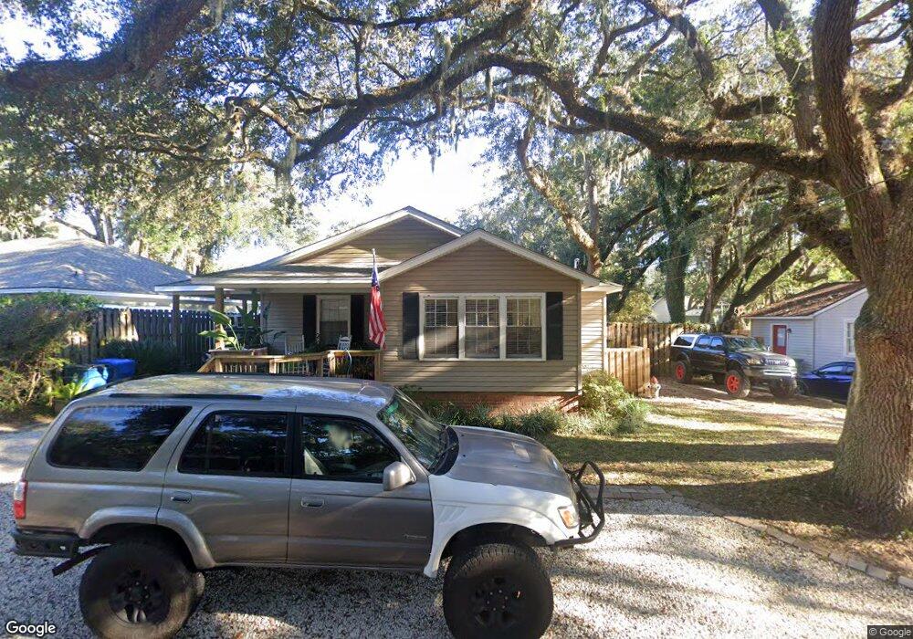
50 Maxwell Ave Saint Simons Island, GA 31522
Estimated Value: $571,236 - $764,000
2
Beds
2
Baths
1,250
Sq Ft
$526/Sq Ft
Est. Value
About This Home
This home is located at 50 Maxwell Ave, Saint Simons Island, GA 31522 and is currently estimated at $657,809, approximately $526 per square foot. 50 Maxwell Ave is a home located in Glynn County with nearby schools including St. Simons Elementary School, Glynn Middle School, and Glynn Academy.
Ownership History
Date
Name
Owned For
Owner Type
Purchase Details
Closed on
Apr 20, 2005
Sold by
Thompson Helen Anne
Bought by
Thompson Helen Anne and Thompson Todd Ray
Current Estimated Value
Create a Home Valuation Report for This Property
The Home Valuation Report is an in-depth analysis detailing your home's value as well as a comparison with similar homes in the area
Home Values in the Area
Average Home Value in this Area
Purchase History
| Date | Buyer | Sale Price | Title Company |
|---|---|---|---|
| Thompson Helen Anne | -- | -- |
Source: Public Records
Tax History Compared to Growth
Tax History
| Year | Tax Paid | Tax Assessment Tax Assessment Total Assessment is a certain percentage of the fair market value that is determined by local assessors to be the total taxable value of land and additions on the property. | Land | Improvement |
|---|---|---|---|---|
| 2025 | $4,309 | $171,800 | $94,880 | $76,920 |
| 2024 | $3,833 | $152,840 | $75,920 | $76,920 |
| 2023 | $757 | $142,920 | $67,760 | $75,160 |
| 2022 | $1,161 | $102,280 | $27,120 | $75,160 |
| 2021 | $1,193 | $80,720 | $27,120 | $53,600 |
| 2020 | $1,202 | $80,720 | $27,120 | $53,600 |
| 2019 | $1,202 | $80,720 | $27,120 | $53,600 |
| 2018 | $1,202 | $80,720 | $27,120 | $53,600 |
| 2017 | $1,202 | $71,200 | $27,120 | $44,080 |
| 2016 | $1,125 | $52,880 | $27,120 | $25,760 |
| 2015 | $1,131 | $52,880 | $27,120 | $25,760 |
| 2014 | $1,131 | $52,880 | $27,120 | $25,760 |
Source: Public Records
Map
Nearby Homes
- 516 Postell Dr
- 104 Youngwood Dr
- 211 Mcintosh Ave
- 202 Vassar Point Dr
- 121 Killgriffe St
- 242 Mcintosh Ave
- 105 Ledbetter Ave
- 2404 Frederica Rd
- 524 Wesley Oak Cir
- 123 Redfern Dr
- 210 Settlers Rd
- 295 Mcintosh Ave
- 207 Military Rd
- 1704 Frederica Rd Unit 237
- 1704 Frederica Rd Unit 621
- 1704 Frederica Rd Unit 628 + 31 garage
- 1704 Frederica Rd Unit 723
- 1704 Frederica Rd Unit 635
- 1704 Frederica Rd Unit 602
- 102 Sapelo St
- 49 Maxwell Ave
- 51 Maxwell Ave
- 146 Mcintosh Ave
- 52 Maxwell Ave
- 48 Maxwell Ave
- 152 Mcintosh Ave
- 140 Mcintosh Ave
- 152 Mcintosh Ave
- 71 Maxwell Ave
- 47 Maxwell Ave
- 53 Maxwell Ave
- 71 Maxwell Ave
- 70 Maxwell Ave
- 158 Mcintosh Ave
- 72 Maxwell Ave
- 69 Maxwell Ave
- 73 Maxwell Ave
- 73 Maxwell Ave
- 46 Maxwell Ave
- 54 Maxwell Ave