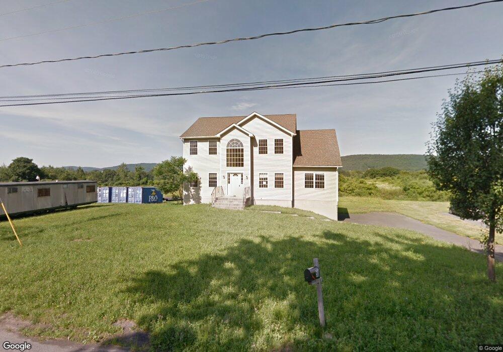
50 Mayer Dr Highland, NY 12528
Highland NeighborhoodEstimated Value: $617,421 - $666,000
4
Beds
3
Baths
2,700
Sq Ft
$238/Sq Ft
Est. Value
About This Home
This home is located at 50 Mayer Dr, Highland, NY 12528 and is currently estimated at $643,855, approximately $238 per square foot. 50 Mayer Dr is a home located in Ulster County with nearby schools including Highland Elementary School, Highland Middle School, and Highland High School.
Ownership History
Date
Name
Owned For
Owner Type
Purchase Details
Closed on
Aug 27, 2014
Sold by
Gt Paltz Llc
Bought by
Duffy Kevin J and Duffy Julie K
Current Estimated Value
Purchase Details
Closed on
May 7, 2014
Sold by
Bank Of New York Mellon
Bought by
Gt Paltz Llc 50
Purchase Details
Closed on
Mar 20, 2014
Sold by
Reinoso Maria
Bought by
The Bank Of Ny Mellon
Purchase Details
Closed on
Aug 15, 2013
Sold by
Bank Of New York Mellon
Bought by
Gt Paltz Llc 50
Purchase Details
Closed on
Oct 27, 2006
Sold by
Hudson Summit Llc
Bought by
Reinoso Roberto and Reinoso Maria Perez
Home Financials for this Owner
Home Financials are based on the most recent Mortgage that was taken out on this home.
Original Mortgage
$46,550
Interest Rate
6.07%
Mortgage Type
Stand Alone Second
Create a Home Valuation Report for This Property
The Home Valuation Report is an in-depth analysis detailing your home's value as well as a comparison with similar homes in the area
Home Values in the Area
Average Home Value in this Area
Purchase History
| Date | Buyer | Sale Price | Title Company |
|---|---|---|---|
| Duffy Kevin J | $297,000 | -- | |
| Gt Paltz Llc 50 | $220,000 | -- | |
| The Bank Of Ny Mellon | $365,532 | -- | |
| The Bank Of Ny Mellon | $365,532 | -- | |
| Gt Paltz Llc 50 | $220,000 | -- | |
| Reinoso Roberto | $479,582 | None Available |
Source: Public Records
Mortgage History
| Date | Status | Borrower | Loan Amount |
|---|---|---|---|
| Previous Owner | Reinoso Roberto | $46,550 | |
| Previous Owner | Reinoso Roberto | $372,600 |
Source: Public Records
Tax History Compared to Growth
Tax History
| Year | Tax Paid | Tax Assessment Tax Assessment Total Assessment is a certain percentage of the fair market value that is determined by local assessors to be the total taxable value of land and additions on the property. | Land | Improvement |
|---|---|---|---|---|
| 2024 | $13,331 | $348,300 | $88,700 | $259,600 |
| 2023 | $13,116 | $348,300 | $88,700 | $259,600 |
| 2022 | $12,929 | $348,300 | $88,700 | $259,600 |
| 2021 | $12,929 | $348,300 | $88,700 | $259,600 |
| 2020 | $11,989 | $344,300 | $88,700 | $255,600 |
| 2019 | $11,131 | $344,300 | $88,700 | $255,600 |
| 2018 | $12,173 | $344,300 | $88,700 | $255,600 |
| 2017 | $11,970 | $344,300 | $88,700 | $255,600 |
| 2016 | $11,729 | $344,300 | $88,700 | $255,600 |
| 2015 | -- | $300,000 | $88,700 | $211,300 |
| 2014 | -- | $300,000 | $88,700 | $211,300 |
Source: Public Records
Map
Nearby Homes
- 57 Mayer Dr
- 30 Mayer Dr
- 4 Salk Dr
- 307 Vineyard Ave
- 243 Vineyard Ave Unit 251
- 224 Vineyard Ave
- 10-32 S Roberts Rd
- 87 Sterling Place
- 3748 Us Highway 9w
- 422 Gregory Ct Unit 307
- 13 Sharon Dr
- 1 Jonathan Ct
- 6 Smith Terrace
- 25 Mile Hill Rd
- 0 Haviland Rd Unit KEY899872
- 29 Oakes Rd
- 123 Vineyard Ave
- 0 White St
- 2 Cambridge Ct
- 8 Sunny Brook Cir