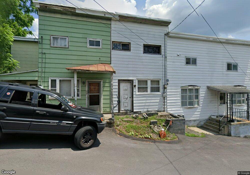
50 Mine St Brockton, PA 17925
Estimated Value: $88,420 - $195,000
3
Beds
1
Bath
1,568
Sq Ft
$81/Sq Ft
Est. Value
About This Home
This home is located at 50 Mine St, Brockton, PA 17925 and is currently estimated at $126,355, approximately $80 per square foot. 50 Mine St is a home located in Schuylkill County with nearby schools including Tamaqua Area Senior High School.
Ownership History
Date
Name
Owned For
Owner Type
Purchase Details
Closed on
Jun 17, 2016
Sold by
Kresge Raymond P and Kresge Brett R
Bought by
Mengle Nicholas J and Dunbar Dana E
Current Estimated Value
Home Financials for this Owner
Home Financials are based on the most recent Mortgage that was taken out on this home.
Original Mortgage
$49,357
Outstanding Balance
$39,372
Interest Rate
3.64%
Mortgage Type
Purchase Money Mortgage
Estimated Equity
$86,983
Purchase Details
Closed on
Apr 19, 2007
Sold by
Rudy Daniel J
Bought by
Kresge Raymond P and Kresge Brett R
Create a Home Valuation Report for This Property
The Home Valuation Report is an in-depth analysis detailing your home's value as well as a comparison with similar homes in the area
Home Values in the Area
Average Home Value in this Area
Purchase History
| Date | Buyer | Sale Price | Title Company |
|---|---|---|---|
| Mengle Nicholas J | $48,000 | Ohio Bar Title Insurance Com | |
| Kresge Raymond P | $22,500 | None Available |
Source: Public Records
Mortgage History
| Date | Status | Borrower | Loan Amount |
|---|---|---|---|
| Open | Mengle Nicholas J | $49,357 |
Source: Public Records
Tax History Compared to Growth
Tax History
| Year | Tax Paid | Tax Assessment Tax Assessment Total Assessment is a certain percentage of the fair market value that is determined by local assessors to be the total taxable value of land and additions on the property. | Land | Improvement |
|---|---|---|---|---|
| 2025 | $1,056 | $14,315 | $2,500 | $11,815 |
| 2024 | $964 | $14,315 | $2,500 | $11,815 |
| 2023 | $964 | $14,315 | $2,500 | $11,815 |
| 2022 | $937 | $14,315 | $2,500 | $11,815 |
| 2021 | $946 | $14,315 | $2,500 | $11,815 |
| 2020 | $926 | $14,315 | $2,500 | $11,815 |
| 2018 | $899 | $14,315 | $2,500 | $11,815 |
| 2017 | $867 | $14,315 | $2,500 | $11,815 |
| 2015 | -- | $14,315 | $2,500 | $11,815 |
| 2011 | -- | $14,315 | $0 | $0 |
Source: Public Records
Map
Nearby Homes
- 609 Catawissa Rd
- 26 Main St
- 28 Main St
- 93 Washington St
- 212 Pine St
- 17 Main St
- 303 Mulberry St
- 409 Coal St
- 1319 Shady Ln
- 199 State Rd
- 4 Federal St
- 15 Alliance St
- 235 Valley St
- 201 Market St
- 199 Market St
- 0 Whitetail Crossing Rd Unit 743729
- 0 Whitetail Crossing Rd
- 111 Hillside Dr
- 0 Ridge Rd
- 931 Barnesville Dr