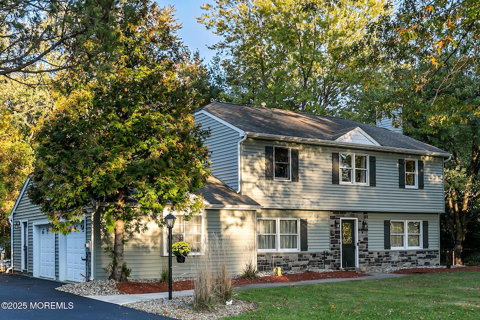
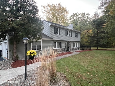

50 Munch Rd Red Bank, NJ 07701
New Monmouth NeighborhoodEstimated payment $6,728/month
Highlights
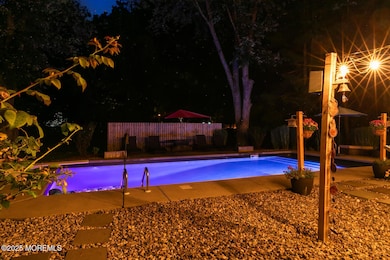
- In Ground Pool
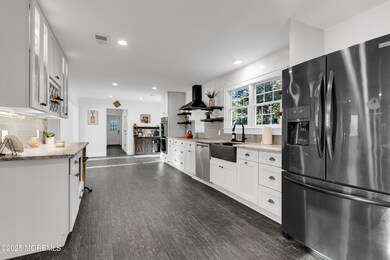
- New Kitchen
- Backs to Trees or Woods
- Nut Swamp Elementary School Rated A-
- Colonial Architecture
- Wood Flooring
About This Home
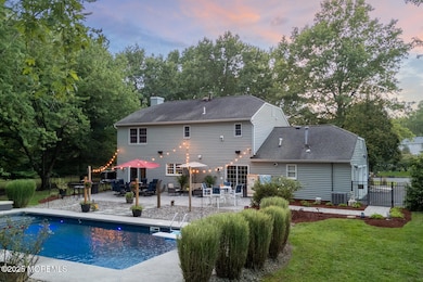
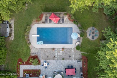
Tucked away on a quiet dead-end street, this 4BR, 2.5BA Colonial offers exceptional privacy and modern comfort. The open-concept layout features a huge kitchen with double wall oven, wine fridge, induction cooktop, radiant heated floors, and two sets of sliders leading to a large paver patio and custom 18×38 saltwater pool. Formal dining room and family room both showcase wide-plank wood floors and crown molding, with the family room centered around an efficient gas fireplace. Upstairs, the primary suite includes a walk-in closet and a luxurious bath with oversized walk-in shower and soaking tub, plus a convenient 2nd-floor laundry and 3 additional spacious bedrooms. Truly a rare find for those seeking space, comfort, and total privacy.
Listing Agent
C21 Thomson & Co. Brokerage Email: yetmanmaureen@gmail.com License #9695557 Listed on: 10/24/2025
Home Details
Home Type
- Single Family
Est. Annual Taxes
- $11,508
Year Built
- Built in 1982
Lot Details
- 0.39 Acre Lot
- Lot Dimensions are 105 x 160
- Street terminates at a dead end
- Fenced
- Backs to Trees or Woods
Parking
- 2 Car Direct Access Garage
- Garage Door Opener
- Double-Wide Driveway
Home Design
- Colonial Architecture
- Shingle Roof
- Asphalt Rolled Roof
- Stone Siding
- Vinyl Siding
- Stone
Interior Spaces
- 2,412 Sq Ft Home
- 2-Story Property
- Crown Molding
- Ceiling Fan
- Recessed Lighting
- Light Fixtures
- Gas Fireplace
- Sliding Doors
- Mud Room
- Family Room
- Dining Room
- Pull Down Stairs to Attic
Kitchen
- New Kitchen
- Eat-In Kitchen
- Double Oven
- Electric Cooktop
- Portable Range
- Range Hood
- Dishwasher
- Granite Countertops
Flooring
- Wood
- Ceramic Tile
Bedrooms and Bathrooms
- 4 Bedrooms
- Primary bedroom located on second floor
- Walk-In Closet
- Primary Bathroom is a Full Bathroom
- Primary Bathroom Bathtub Only
- Soaking Tub
- Primary Bathroom includes a Walk-In Shower
Laundry
- Laundry Room
- Dryer
- Washer
Pool
- In Ground Pool
- Saltwater Pool
- Vinyl Pool
Outdoor Features
- Patio
- Exterior Lighting
- Shed
- Storage Shed
Schools
- Nut Swamp Elementary School
- Thompson Middle School
- Middle South High School
Utilities
- Forced Air Heating and Cooling System
- Radiant Heating System
- Tankless Water Heater
- Natural Gas Water Heater
Community Details
- No Home Owners Association
- Shadowbrook Subdivision
Listing and Financial Details
- Exclusions: Primary bath mirror
- Assessor Parcel Number 32-01002-0000-00021
Map
Home Values in the Area
Average Home Value in this Area
Tax History
| Year | Tax Paid | Tax Assessment Tax Assessment Total Assessment is a certain percentage of the fair market value that is determined by local assessors to be the total taxable value of land and additions on the property. | Land | Improvement |
|---|---|---|---|---|
| 2025 | $11,508 | $878,600 | $502,000 | $376,600 |
| 2024 | $11,848 | $699,600 | $324,900 | $374,700 |
| 2023 | $11,848 | $681,700 | $315,800 | $365,900 |
| 2022 | $11,367 | $603,500 | $245,800 | $357,700 |
| 2021 | $11,367 | $546,500 | $228,400 | $318,100 |
| 2020 | $11,763 | $550,200 | $235,300 | $314,900 |
| 2019 | $11,430 | $541,200 | $235,300 | $305,900 |
| 2018 | $11,216 | $517,600 | $235,300 | $282,300 |
| 2017 | $10,499 | $494,300 | $220,600 | $273,700 |
| 2016 | $10,465 | $491,100 | $245,600 | $245,500 |
| 2015 | $10,014 | $468,800 | $225,600 | $243,200 |
| 2014 | $9,586 | $437,900 | $215,600 | $222,300 |
Property History
| Date | Event | Price | List to Sale | Price per Sq Ft |
|---|---|---|---|---|
| 10/31/2025 10/31/25 | Pending | -- | -- | -- |
| 10/24/2025 10/24/25 | For Sale | $1,100,000 | -- | $456 / Sq Ft |
Purchase History
| Date | Type | Sale Price | Title Company |
|---|---|---|---|
| Sheriffs Deed | $924,752 | None Available | |
| Deed | $445,000 | -- | |
| Deed | $287,500 | -- |
Mortgage History
| Date | Status | Loan Amount | Loan Type |
|---|---|---|---|
| Closed | $410,400 | Construction | |
| Previous Owner | $358,000 | No Value Available | |
| Previous Owner | $198,000 | No Value Available |
Source: MOREMLS (Monmouth Ocean Regional REALTORS®)
MLS Number: 22532167
APN: 32-01002-0000-00021
Disclaimer: Certain information contained herein is derived from information provided by parties other than Homes.com. All information provided is deemed reliable, but is not guaranteed to be accurate and should be independently verified.
![]() IDX information is provided exclusively for personal, non-commercial use, and may not be used for any purpose other than to identify prospective properties consumers may be interested in purchasing.
IDX information is provided exclusively for personal, non-commercial use, and may not be used for any purpose other than to identify prospective properties consumers may be interested in purchasing.
Information is deemed reliable but not guaranteed.
- 8 Fowler Ct
- 109 Lexington Ct
- 143 Lexington Ct
- 163 Lexington Ct
- 50 Hancock Ct Unit 129B
- 11 Mayflower Dr
- 7 Lexington Ct
- 60 Falmouth Ct
- 19 Manchester Ct
- 11 Manchester Ct
- 126 Manchester Ct
- 7 Boxwood Terrace Unit 250
- 25 Claremont Ct
- 12 Ellsworth Ct
- 40 Ellsworth Ct
- 16 Concord Ct Unit 15D
- 22 Claremont Ct Unit 33E
- 32 Ellsworth Ct
- 88 Friendship Ct
- 24 Princeton St
