
Seller's Agent in 2026
Stephen Crager
Berkshire Hathaway HomeServices Carolina Premier Properties
(910) 508-3112
15 in this area
34 Total Sales
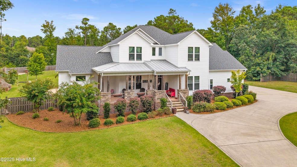


Welcome to one of the most unique and captivating estates in all of Hampstead. Perfectly tucked away yet centrally located, this hidden gem sits on nearly four acres of beautifully maintained land with no HOA—offering both privacy and unmatched convenience. The main residence is a 3,640-square-foot custom-built home featuring four spacious bedrooms, three and a half baths, multiple bonus spaces and a true 3 car garage designed for flexibility and comfort. Thoughtful interior details include 10-foot ceilings, 8-foot interior doors, custom trim work, a chef's kitchen, a built-in surround sound system, a tankless water heater, and hardwood and tile flooring throughout. Step outside and enjoy the best of Coastal North Carolina living. The expansive back porch is ideal for relaxing or entertaining, complete with a gas fireplace, outdoor TV, and integrated sound system. Just steps away, you'll find a stunning saltwater pool, a charming tiki hut, and ample outdoor seating—creating the perfect space for hosting gatherings or simply unwinding in your private oasis. In addition to the main home, the property includes a beautifully appointed second residence of approximately 1,200 square feet. Whether used as a guest house, in-law suite, or rental property, it offers comfort and style with carefully selected finishes. The screened-in porch with its own gas fireplace adds a cozy, inviting touch that sets it apart. This is a rare opportunity to own a truly special property in the heart of Hampstead. For a private showing, please contact the listing agent directly or have your agent schedule a tour. Pre-approval is strongly recommended prior to viewing.
Last Agent to Sell the Property
Berkshire Hathaway HomeServices Carolina Premier Properties License #273615 Listed on: 09/16/2025
| Date | Type | Sale Price | Title Company |
|---|---|---|---|
| Quit Claim Deed | -- | None Listed On Document | |
| Warranty Deed | $107,500 | None Available | |
| Warranty Deed | -- | None Available |
| Date | Status | Loan Amount | Loan Type |
|---|---|---|---|
| Previous Owner | $80,625 | Unknown |
| Date | Event | Price | List to Sale | Price per Sq Ft |
|---|---|---|---|---|
| 01/09/2026 01/09/26 | Sold | $1,225,000 | -11.9% | $337 / Sq Ft |
| 12/12/2025 12/12/25 | Off Market | $1,390,000 | -- | -- |
| 11/09/2025 11/09/25 | Pending | -- | -- | -- |
| 11/08/2025 11/08/25 | Pending | -- | -- | -- |
| 10/13/2025 10/13/25 | Price Changed | $1,390,000 | -0.4% | $382 / Sq Ft |
| 09/16/2025 09/16/25 | For Sale | $1,395,000 | -- | $383 / Sq Ft |
| Year | Tax Paid | Tax Assessment Tax Assessment Total Assessment is a certain percentage of the fair market value that is determined by local assessors to be the total taxable value of land and additions on the property. | Land | Improvement |
|---|---|---|---|---|
| 2024 | $4,232 | $435,896 | $112,369 | $323,527 |
| 2023 | $4,232 | $435,896 | $112,369 | $323,527 |
| 2022 | $3,002 | $334,120 | $112,369 | $221,751 |
| 2021 | $2,782 | $334,120 | $112,369 | $221,751 |
| 2020 | $2,782 | $334,120 | $112,369 | $221,751 |
| 2019 | $3,002 | $334,120 | $112,369 | $221,751 |
| 2018 | $436 | $50,000 | $50,000 | $0 |
| 2017 | $436 | $50,000 | $50,000 | $0 |
| 2016 | $431 | $50,000 | $50,000 | $0 |
| 2015 | -- | $50,000 | $50,000 | $0 |
Seller's Agent in 2026
Stephen Crager
Berkshire Hathaway HomeServices Carolina Premier Properties
(910) 508-3112
15 in this area
34 Total Sales
Buyer's Agent in 2026
Kristin Freeman
BlueStar Real Estate, LLC
(910) 508-6077
17 in this area
51 Total Sales
Source: Hive MLS
MLS Number: 100530875
APN: 4203-51-5690-0000
Disclaimer: Certain information contained herein is derived from information provided by parties other than Homes.com. All information provided is deemed reliable, but is not guaranteed to be accurate and should be independently verified.
![]() The data relating to real estate on this web site comes in part from the Internet Data Exchange program of Hive MLS LLC. All information is deemed reliable but not guaranteed and should be independently verified. All properties are subject to prior sale, change, or withdrawal. Neither listing broker(s) nor Homesnap, Inc. shall be responsible for any typographical errors, misinformation, or misprints, and shall be held totally harmless from any damages arising from reliance upon these data. ©2026 Hive MLS LLC
The data relating to real estate on this web site comes in part from the Internet Data Exchange program of Hive MLS LLC. All information is deemed reliable but not guaranteed and should be independently verified. All properties are subject to prior sale, change, or withdrawal. Neither listing broker(s) nor Homesnap, Inc. shall be responsible for any typographical errors, misinformation, or misprints, and shall be held totally harmless from any damages arising from reliance upon these data. ©2026 Hive MLS LLC