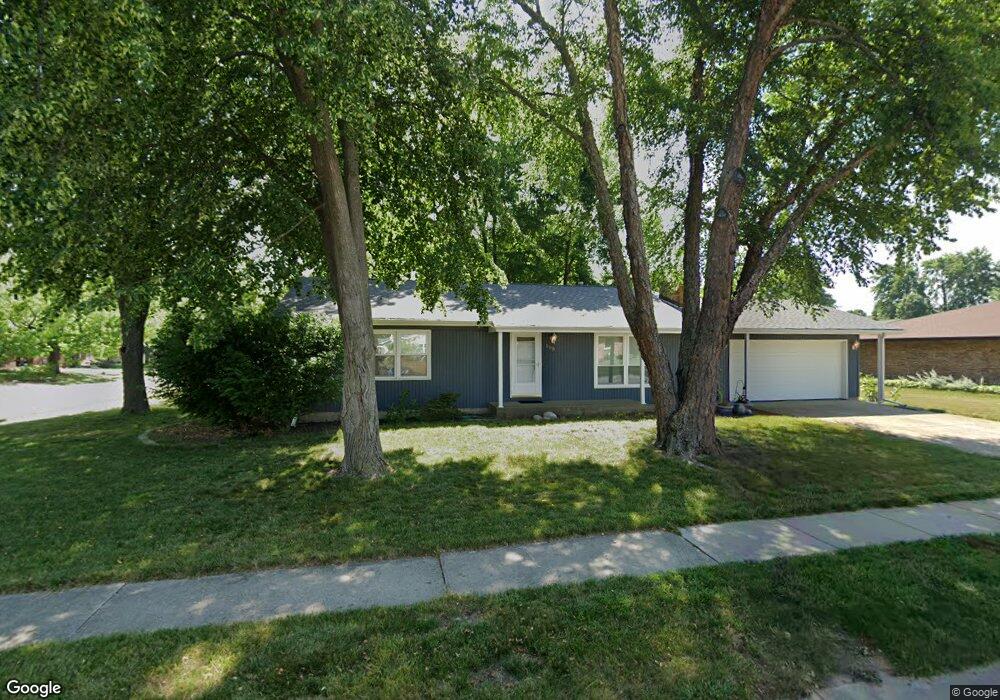
500 Avondale Dr Springfield, IL 62704
Pasfield Park Place NeighborhoodEstimated Value: $202,000 - $233,000
3
Beds
2
Baths
1,344
Sq Ft
$156/Sq Ft
Est. Value
About This Home
This home is located at 500 Avondale Dr, Springfield, IL 62704 and is currently estimated at $209,988, approximately $156 per square foot. 500 Avondale Dr is a home located in Sangamon County with nearby schools including Dubois Elementary School, U.S. Grant Middle School, and Springfield High School.
Ownership History
Date
Name
Owned For
Owner Type
Purchase Details
Closed on
Jul 27, 2020
Sold by
Anne Brauer Laura
Bought by
Hodel Vie Elizabeth and Hodel Sydney Cathleen
Current Estimated Value
Purchase Details
Closed on
Jul 24, 2020
Sold by
Brauer Laura Anne
Bought by
Brauer Laura Anne and Hodel Vie Elizabeth
Purchase Details
Closed on
May 28, 2008
Purchase Details
Closed on
Nov 2, 2000
Purchase Details
Closed on
Oct 20, 1997
Create a Home Valuation Report for This Property
The Home Valuation Report is an in-depth analysis detailing your home's value as well as a comparison with similar homes in the area
Home Values in the Area
Average Home Value in this Area
Purchase History
| Date | Buyer | Sale Price | Title Company |
|---|---|---|---|
| Hodel Vie Elizabeth | -- | Moehle Swearingen & Lobacz Ltd | |
| Brauer Laura Anne | -- | -- | |
| -- | $114,400 | -- | |
| -- | $97,000 | -- | |
| -- | $86,000 | -- |
Source: Public Records
Tax History
| Year | Tax Paid | Tax Assessment Tax Assessment Total Assessment is a certain percentage of the fair market value that is determined by local assessors to be the total taxable value of land and additions on the property. | Land | Improvement |
|---|---|---|---|---|
| 2024 | $4,817 | $57,354 | $9,540 | $47,814 |
| 2023 | $4,170 | $47,168 | $8,714 | $38,454 |
| 2022 | $3,980 | $44,413 | $8,267 | $36,146 |
| 2021 | $3,308 | $42,750 | $7,957 | $34,793 |
| 2020 | $3,243 | $42,814 | $7,969 | $34,845 |
| 2019 | $3,181 | $42,664 | $7,941 | $34,723 |
| 2018 | $3,080 | $42,456 | $7,902 | $34,554 |
| 2017 | $3,010 | $41,907 | $7,800 | $34,107 |
| 2016 | $2,944 | $41,296 | $7,686 | $33,610 |
| 2015 | $2,909 | $40,802 | $7,594 | $33,208 |
| 2014 | $2,791 | $40,539 | $7,545 | $32,994 |
| 2013 | $2,729 | $39,679 | $7,545 | $32,134 |
Source: Public Records
Map
Nearby Homes
- 504 Brandywine Rd
- 160 S Durkin Dr Unit 4
- 2309 W Lawrence Ave
- 107 Collier Dr
- 2138 W Lawrence Ave
- 2134 W Lawrence Ave
- 2 Interlacken Rd
- 29 N Oxford Rd
- 2028 Parkview Dr
- 2553 Chapel Hill Dr
- 3 Greenview Ct
- 49 Bellerive Rd
- 3116 Kensington Dr
- 3229 W Point Dr
- 17 Hollybrook Dr
- 2000 Oak Creek Rd
- 161 Cypress Point Dr
- 2612 Cedar Pond Dr
- 1914 Jeanette Ln Unit 6
- 604 Rock River Rd
- 2624 W Lawrence Ave
- 508 Avondale Dr
- 2649 Baronne Dr
- 2620 W Lawrence Ave
- 505 Avondale Dr
- 2629 W Lawrence Ave
- 2636 W Lawrence Ave
- 2633 W Lawrence Ave
- 509 Avondale Dr
- 2637 W Lawrence Ave
- 2625 W Lawrence Ave
- 2645 Baronne Dr
- 2616 W Lawrence Ave
- 2641 W Lawrence Ave
- 511 Avondale Dr
- 2654 Baronne Dr
- 2641 Baronne Dr
- 2658 -2660 Baronne Dr
- 2644 Sarona Rd
- 2650 Baronne Dr
Your Personal Tour Guide
Ask me questions while you tour the home.