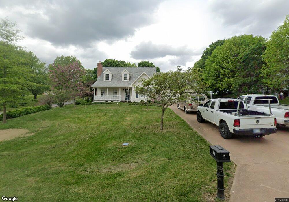
500 Maple Ln Camden Point, MO 64018
Estimated Value: $256,000 - $351,000
3
Beds
3
Baths
1,946
Sq Ft
$160/Sq Ft
Est. Value
About This Home
This home is located at 500 Maple Ln, Camden Point, MO 64018 and is currently estimated at $311,842, approximately $160 per square foot. 500 Maple Ln is a home located in Platte County with nearby schools including North Platte Elementary School, North Platte Intermediate School, and North Platte Junior High School.
Ownership History
Date
Name
Owned For
Owner Type
Purchase Details
Closed on
Jul 19, 2017
Sold by
Schimke Barbara J
Bought by
Dutcher Vernon
Current Estimated Value
Home Financials for this Owner
Home Financials are based on the most recent Mortgage that was taken out on this home.
Original Mortgage
$171,000
Outstanding Balance
$141,341
Interest Rate
3.88%
Mortgage Type
New Conventional
Estimated Equity
$170,501
Purchase Details
Closed on
Sep 23, 2008
Sold by
Dutcher Construction Co Inc
Bought by
Schimke Barbara J
Purchase Details
Closed on
Jul 3, 2007
Sold by
Schimke Barbara Jean
Bought by
Dutcher Construction Co Inc
Create a Home Valuation Report for This Property
The Home Valuation Report is an in-depth analysis detailing your home's value as well as a comparison with similar homes in the area
Purchase History
| Date | Buyer | Sale Price | Title Company |
|---|---|---|---|
| Dutcher Vernon | -- | First United Title Agency Ll | |
| Schimke Barbara J | -- | Platte County & Abstract | |
| Dutcher Construction Co Inc | -- | None Available | |
| Schimke Barbara Jean | -- | None Available |
Source: Public Records
Mortgage History
| Date | Status | Borrower | Loan Amount |
|---|---|---|---|
| Open | Dutcher Vernon | $171,000 |
Source: Public Records
Tax History
| Year | Tax Paid | Tax Assessment Tax Assessment Total Assessment is a certain percentage of the fair market value that is determined by local assessors to be the total taxable value of land and additions on the property. | Land | Improvement |
|---|---|---|---|---|
| 2025 | $2,705 | $36,085 | $3,800 | $32,285 |
| 2024 | $2,705 | $36,085 | $3,800 | $32,285 |
| 2023 | $2,592 | $36,085 | $3,800 | $32,285 |
| 2022 | $2,286 | $31,515 | $3,800 | $27,715 |
| 2021 | $2,293 | $31,515 | $3,800 | $27,715 |
| 2020 | $2,081 | $27,964 | $3,800 | $24,164 |
| 2019 | $2,081 | $27,964 | $3,800 | $24,164 |
| 2018 | $2,094 | $27,964 | $3,800 | $24,164 |
| 2017 | $2,093 | $27,964 | $3,800 | $24,164 |
| 2016 | $2,072 | $27,964 | $3,800 | $24,164 |
| 2015 | $2,072 | $27,964 | $3,800 | $24,164 |
| 2013 | -- | $27,964 | $0 | $0 |
Source: Public Records
Map
Nearby Homes
- 19710 Kansas City Blvd
- 19255 Lane Tree Dr
- U Highway
- 0 U Hwy Unit HMS2588353
- 0001 Edgerton Junction Rd
- 0000 Edgerton Junction Rd
- 17980 Lakewood Dr
- 21205 B Hwy Unit B
- 0 Gooseneck Bend Rd
- 21195 Edgerton Junction Rd
- 0 Cockriel Rd
- 103 Johnson Cir
- 21970 Lamar Rd
- 601 Main St
- 20860 County Road P
- 5990 Z Hwy
- 107 Johnson Cir
- 109 Johnson Cir
- 108 Johnson Cir
- 103 Sally Cir
Your Personal Tour Guide
Ask me questions while you tour the home.