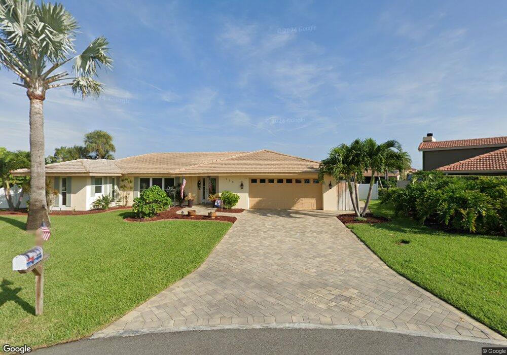
500 Red Sail Way Satellite Beach, FL 32937
Estimated Value: $832,000 - $1,451,000
4
Beds
3
Baths
2,735
Sq Ft
$386/Sq Ft
Est. Value
About This Home
This home is located at 500 Red Sail Way, Satellite Beach, FL 32937 and is currently estimated at $1,056,241, approximately $386 per square foot. 500 Red Sail Way is a home located in Brevard County with nearby schools including Sea Park Elementary School, Satellite Senior High School, and DeLaura Middle School.
Ownership History
Date
Name
Owned For
Owner Type
Purchase Details
Closed on
Oct 8, 2010
Sold by
Gagnon Margaret B and Margaret B Gagnon Revocable Tr
Bought by
Hennessy Stephen M and Hennesy Tamila
Current Estimated Value
Home Financials for this Owner
Home Financials are based on the most recent Mortgage that was taken out on this home.
Original Mortgage
$408,000
Outstanding Balance
$3,083
Interest Rate
4.37%
Estimated Equity
$1,053,158
Purchase Details
Closed on
Aug 19, 1996
Sold by
Gagnon George A and Gagnon Margaret B
Bought by
Gagnon Margaret B
Create a Home Valuation Report for This Property
The Home Valuation Report is an in-depth analysis detailing your home's value as well as a comparison with similar homes in the area
Home Values in the Area
Average Home Value in this Area
Purchase History
| Date | Buyer | Sale Price | Title Company |
|---|---|---|---|
| Hennessy Stephen M | $514,400 | Security First Title & Escro | |
| Gagnon Margaret B | -- | -- |
Source: Public Records
Mortgage History
| Date | Status | Borrower | Loan Amount |
|---|---|---|---|
| Open | Hennessy Stephen M | $408,000 |
Source: Public Records
Tax History Compared to Growth
Tax History
| Year | Tax Paid | Tax Assessment Tax Assessment Total Assessment is a certain percentage of the fair market value that is determined by local assessors to be the total taxable value of land and additions on the property. | Land | Improvement |
|---|---|---|---|---|
| 2025 | $5,095 | $410,080 | -- | -- |
| 2024 | $5,100 | $398,530 | -- | -- |
| 2023 | $5,100 | $392,020 | $0 | $0 |
| 2022 | $4,768 | $380,610 | $0 | $0 |
| 2021 | $4,989 | $369,530 | $0 | $0 |
| 2020 | $4,930 | $364,430 | $0 | $0 |
| 2019 | $4,898 | $356,240 | $0 | $0 |
| 2018 | $4,922 | $349,600 | $0 | $0 |
| 2017 | $4,990 | $342,410 | $0 | $0 |
| 2016 | $5,095 | $335,370 | $225,500 | $109,870 |
| 2015 | $5,262 | $333,040 | $225,500 | $107,540 |
| 2014 | $5,306 | $330,400 | $209,000 | $121,400 |
Source: Public Records
Map
Nearby Homes
- 471 Lighthouse Landing St
- 124 Lanternback Island Dr
- 142 Lanternback Island Dr
- 419 Lanternback Island Dr
- 484 Lanternback Island Dr
- 465 Cardinal Dr
- 428 Penguin Dr
- 458 Sandpiper Dr
- 341 Lanternback Island Dr
- 435 Sandpiper Dr
- 418 Sandpiper Dr
- 333 S Patrick Dr Unit 11
- 406 Thrush Dr
- 49 Sorrento Ct
- 256 Lanternback Island Dr
- 349 W Arlington St
- 406 Skylark Blvd
- 341 W Arlington St
- 444 Blue Jay Ln Unit 13
- 432 Blue Jay Ln Unit 62
- 496 Red Sail Way
- 501 Red Sail Way
- 481 Sailfish Cove
- 492 Red Sail Way
- 477 Sailfish Cove
- 497 Red Sail Way
- 473 Sailfish Cove
- 493 Red Sail Way
- 488 Red Sail Way
- 488 Sailfish Cove
- 489 Red Sail Way
- 469 Sailfish Cove
- 484 Red Sail Way
- 106 Lanternback Island Dr
- 476 Red Sail Way
- 485 Red Sail Way
- 484 Sailfish Cove
- 100 Lanternback Island Dr
- 473 Saint Lucia Ct
- 465 Sailfish Cove