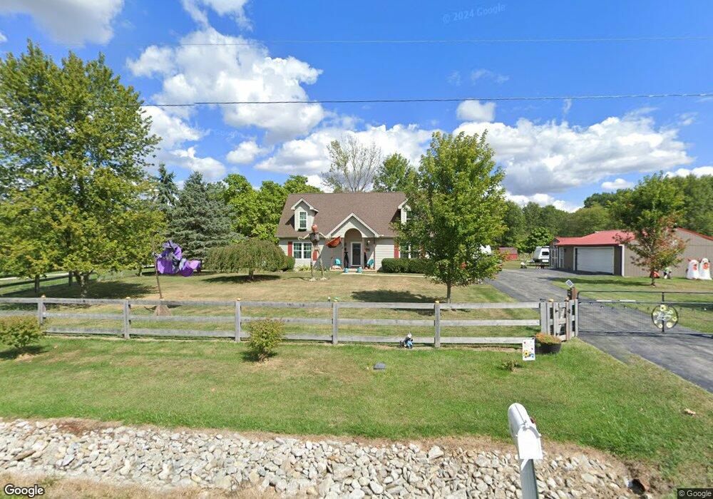
5008 N State Route 133 Blanchester, OH 45107
Estimated Value: $258,000 - $352,176
2
Beds
1
Bath
1,732
Sq Ft
$178/Sq Ft
Est. Value
About This Home
This home is located at 5008 N State Route 133, Blanchester, OH 45107 and is currently estimated at $308,044, approximately $177 per square foot. 5008 N State Route 133 is a home located in Clinton County with nearby schools including Clinton-Massie Elementary School, Clinton-Massie Middle School, and Clinton-Massie High School.
Ownership History
Date
Name
Owned For
Owner Type
Purchase Details
Closed on
Jan 15, 2013
Sold by
Poynter Jason S and Poynter Heather G
Bought by
Poynter Jason S and Poynter Heather G
Current Estimated Value
Home Financials for this Owner
Home Financials are based on the most recent Mortgage that was taken out on this home.
Original Mortgage
$153,535
Outstanding Balance
$107,400
Interest Rate
3.5%
Mortgage Type
FHA
Estimated Equity
$200,644
Purchase Details
Closed on
May 15, 1999
Bought by
Poynter Jason S
Purchase Details
Closed on
Nov 20, 1995
Sold by
Poynter Jason S
Bought by
Poynter Jason S
Create a Home Valuation Report for This Property
The Home Valuation Report is an in-depth analysis detailing your home's value as well as a comparison with similar homes in the area
Home Values in the Area
Average Home Value in this Area
Purchase History
| Date | Buyer | Sale Price | Title Company |
|---|---|---|---|
| Poynter Jason S | -- | -- | |
| Poynter Jason S | -- | -- | |
| Poynter Jason S | -- | -- |
Source: Public Records
Mortgage History
| Date | Status | Borrower | Loan Amount |
|---|---|---|---|
| Open | Poynter Jason S | $153,535 |
Source: Public Records
Tax History Compared to Growth
Tax History
| Year | Tax Paid | Tax Assessment Tax Assessment Total Assessment is a certain percentage of the fair market value that is determined by local assessors to be the total taxable value of land and additions on the property. | Land | Improvement |
|---|---|---|---|---|
| 2024 | $3,022 | $89,250 | $23,660 | $65,590 |
| 2023 | $3,022 | $89,250 | $23,660 | $65,590 |
| 2022 | $2,235 | $60,980 | $10,370 | $50,610 |
| 2021 | $2,237 | $60,980 | $10,370 | $50,610 |
| 2020 | $2,197 | $60,980 | $10,370 | $50,610 |
| 2019 | $1,779 | $50,320 | $12,000 | $38,320 |
| 2018 | $1,800 | $50,320 | $12,000 | $38,320 |
| 2017 | $1,752 | $50,320 | $12,000 | $38,320 |
| 2016 | $1,506 | $43,110 | $13,390 | $29,720 |
| 2015 | $1,506 | $43,110 | $13,390 | $29,720 |
| 2013 | $1,548 | $42,580 | $13,390 | $29,190 |
Source: Public Records
Map
Nearby Homes
- 582 Nauvoo Rd
- 420 Kensington Dr
- 450 Pansy Rd
- 4255 Nicholson Rd
- 1850 Irvin Rd
- 100ac Irvin Rd
- 85 Acres Templin Rd
- 10930 Henry-Plummert Rd
- 9132 St Rt 730
- 9132 State Route 730
- 5 Fischer Rd
- 6069 Middleboro Rd
- 2858 Gum Grove Rd
- 6748 Starkey Clevenger Rd
- 279 Frances Dr
- 9356 Ohio 350
- 5182 Middleboro Rd
- 6160 Edwardsville Rd
- 1623 Reeder Rd
- 4946 N State Route 133
- 4946 N State Route 133
- 4998 N State Route 133
- 5166 N State Route 133
- 5220 N St Rt 133
- 5254 N State Route 133
- 5290 N State Route 133
- 5334 N State Route 133
- 5160 N State Route 133
- 5408 N State Route 133
- 5514 N State Route 133
- 5556 N State Route 133
- 5556 St Rt 133 N
- 4496 N State Route 133
- 5672 N State Route 133
- 1255 Nauvoo Rd
- 1283 Nauvoo Rd
- 0 St Rt 133 Unit 1143950
- 0 St Rt 133 Unit 1269271
- 876 Nauvoo Rd