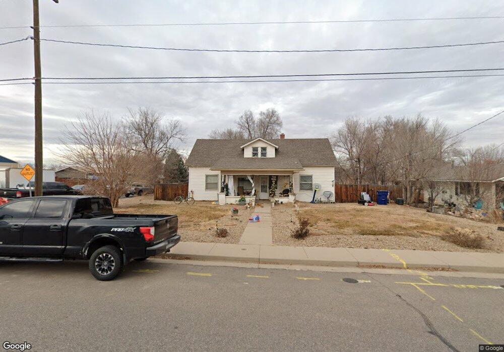
501 Broad St Milliken, CO 80543
Estimated Value: $310,000 - $387,000
4
Beds
1
Bath
1,370
Sq Ft
$254/Sq Ft
Est. Value
About This Home
This home is located at 501 Broad St, Milliken, CO 80543 and is currently estimated at $347,760, approximately $253 per square foot. 501 Broad St is a home located in Weld County with nearby schools including Milliken Elementary School, Milliken Middle School, and Roosevelt High School.
Ownership History
Date
Name
Owned For
Owner Type
Purchase Details
Closed on
Aug 20, 2010
Sold by
Deutsche Bank National Trust Company
Bought by
Garcia Saul and Garcia Maria E
Current Estimated Value
Purchase Details
Closed on
May 19, 2008
Sold by
Willard Dixie B and Willard James E
Bought by
Deutsche Bank National Trust Co
Purchase Details
Closed on
Nov 15, 2001
Sold by
Willard Dixie B
Bought by
Willard James E and Willard Dixie B
Home Financials for this Owner
Home Financials are based on the most recent Mortgage that was taken out on this home.
Original Mortgage
$98,000
Interest Rate
6.59%
Purchase Details
Closed on
Oct 5, 1995
Sold by
Survey
Bought by
Survey
Create a Home Valuation Report for This Property
The Home Valuation Report is an in-depth analysis detailing your home's value as well as a comparison with similar homes in the area
Home Values in the Area
Average Home Value in this Area
Purchase History
| Date | Buyer | Sale Price | Title Company |
|---|---|---|---|
| Garcia Saul | $35,000 | Fidelity National Title Insu | |
| Deutsche Bank National Trust Co | -- | None Available | |
| Willard James E | $133,500 | Stewart Title | |
| Survey | -- | -- |
Source: Public Records
Mortgage History
| Date | Status | Borrower | Loan Amount |
|---|---|---|---|
| Previous Owner | Willard James E | $98,000 |
Source: Public Records
Tax History Compared to Growth
Tax History
| Year | Tax Paid | Tax Assessment Tax Assessment Total Assessment is a certain percentage of the fair market value that is determined by local assessors to be the total taxable value of land and additions on the property. | Land | Improvement |
|---|---|---|---|---|
| 2025 | $1,076 | $14,460 | $4,380 | $10,080 |
| 2024 | $1,076 | $14,460 | $4,380 | $10,080 |
| 2023 | $1,099 | $14,710 | $3,720 | $10,990 |
| 2022 | $1,438 | $12,310 | $3,820 | $8,490 |
| 2021 | $1,554 | $12,670 | $3,930 | $8,740 |
| 2020 | $889 | $7,400 | $3,290 | $4,110 |
| 2019 | $698 | $7,400 | $3,290 | $4,110 |
| 2018 | $707 | $7,330 | $2,880 | $4,450 |
| 2017 | $708 | $7,330 | $2,880 | $4,450 |
| 2016 | $616 | $6,320 | $1,550 | $4,770 |
| 2015 | $626 | $6,320 | $1,550 | $4,770 |
| 2014 | $507 | $5,180 | $1,190 | $3,990 |
Source: Public Records
Map
Nearby Homes
- 105 S Laura Ave
- 103 N Josephine Ave Unit LOT 36
- 104 S Laura Ave
- 106 S Laura Ave
- 204 N Olive Ave
- 106 N Pauline Ave
- 209 S Josephine Ave
- 218 S Josephine Ave
- 0 Broad St Unit RECIR992751
- 0 Broad St Unit RECIR992750
- 300 S Quentine Ave
- 226 W Forest St
- 208 S Frances Ave
- 1398 S Irene Ave
- 1415 Broad St
- 280 E Katsura St
- 944 S Lilac Ct
- 381 E Mountain Ash St
- 140 E Lilac St
- 23395 State Highway 257
- 507 Broad St
- 100 N Marjorie Ave
- 417 Broad St
- 517 Broad St
- 101 N Marjorie Ave
- 101 N Laura Ave
- 508 Broad St
- 104 N Marjorie Ave
- 103 N Marjorie Ave
- 103 N Laura Ave
- 415 Broad St
- 105 S Marjorie Ave
- 101 S Laura Ave
- 105 N Marjorie Ave
- 106 N Marjorie Ave
- 100 N Laura Ave
- 410 Broad St
- 103 S Laura Ave
- 110 S Marjorie Ave
- 405 Broad St