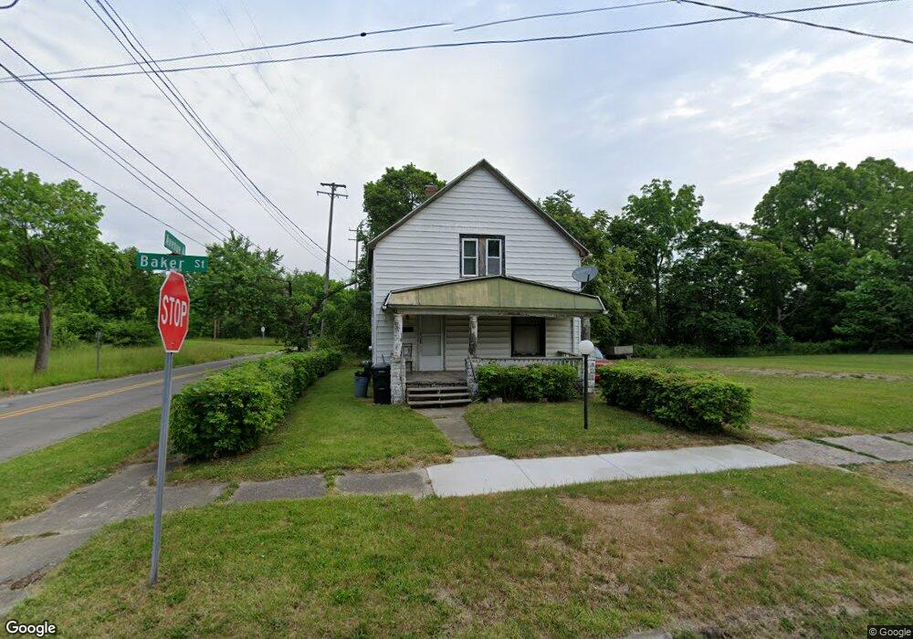
501 E Baker St Flint, MI 48505
King Avenue Plus NeighborhoodEstimated Value: $32,000 - $45,000
4
Beds
1
Bath
1,194
Sq Ft
$34/Sq Ft
Est. Value
About This Home
This home is located at 501 E Baker St, Flint, MI 48505 and is currently estimated at $40,484, approximately $33 per square foot. 501 E Baker St is a home located in Genesee County with nearby schools including Brownell STEM Academy, Flint Cultural Center Academy, and WAY Academy of Flint.
Ownership History
Date
Name
Owned For
Owner Type
Purchase Details
Closed on
May 1, 2006
Sold by
Boyland Larry D
Bought by
Boyland Larry D and Boyland Shondrea Y
Current Estimated Value
Home Financials for this Owner
Home Financials are based on the most recent Mortgage that was taken out on this home.
Original Mortgage
$22,500
Interest Rate
6.39%
Mortgage Type
Fannie Mae Freddie Mac
Purchase Details
Closed on
May 19, 2003
Sold by
Boyland Relerford Rosa D
Bought by
Boyland Larry D
Purchase Details
Closed on
Dec 18, 2000
Sold by
Boyland James E
Bought by
Boyland Larry D
Create a Home Valuation Report for This Property
The Home Valuation Report is an in-depth analysis detailing your home's value as well as a comparison with similar homes in the area
Home Values in the Area
Average Home Value in this Area
Purchase History
| Date | Buyer | Sale Price | Title Company |
|---|---|---|---|
| Boyland Larry D | -- | None Available | |
| Boyland Larry D | -- | First American Title Ins Co | |
| Boyland Larry D | -- | Cislo Title Company |
Source: Public Records
Mortgage History
| Date | Status | Borrower | Loan Amount |
|---|---|---|---|
| Closed | Boyland Larry D | $22,500 |
Source: Public Records
Tax History
| Year | Tax Paid | Tax Assessment Tax Assessment Total Assessment is a certain percentage of the fair market value that is determined by local assessors to be the total taxable value of land and additions on the property. | Land | Improvement |
|---|---|---|---|---|
| 2025 | $435 | $7,900 | $0 | $0 |
| 2024 | $418 | $7,700 | $0 | $0 |
| 2023 | $422 | $4,400 | $0 | $0 |
| 2022 | $0 | $3,900 | $0 | $0 |
| 2021 | $419 | $4,000 | $0 | $0 |
| 2020 | $403 | $5,500 | $0 | $0 |
| 2019 | $1,585 | $6,000 | $0 | $0 |
| 2018 | $1,356 | $7,200 | $0 | $0 |
| 2017 | $553 | $0 | $0 | $0 |
| 2016 | $323 | $0 | $0 | $0 |
| 2015 | -- | $0 | $0 | $0 |
| 2014 | -- | $0 | $0 | $0 |
| 2012 | -- | $2,800 | $0 | $0 |
Source: Public Records
Map
Nearby Homes
- 630 E Dartmouth St
- 218 E Jackson Ave
- 2217 Francis Ave
- 115 E Genesee St
- 310 White St
- 200 W Mcclellan St
- 132 W Jamieson St
- 1710 Wilberforce Cir
- 1706 Wilberforce Cir
- 217 W Dewey St
- 800 Martin Luther King Ave
- 409 W Genesee St
- 320 W Mcclellan St
- 1606 Garland St
- 432 W Dartmouth St
- 506 Green St
- 501 W Witherbee St
- 3810 Marvin St
- 1303 Root St
- 1620 Mason St
- 504 E Rankin St
- 517 E Baker St
- 502 E Baker St
- 2521 Avenue A
- 506 E Baker St
- 435 E Baker St
- 510 E Baker St
- 525 E Baker St
- 2417 Avenue A
- 524 E Rankin St
- 427 E Baker St
- 524 E Baker St
- 438 E Baker St
- 422 E Rankin St
- 423 E Baker St
- 434 E Baker St
- 503 E Dayton St
- 509 E Rankin St
- 2607 Avenue A
- 513 E Rankin St
Your Personal Tour Guide
Ask me questions while you tour the home.