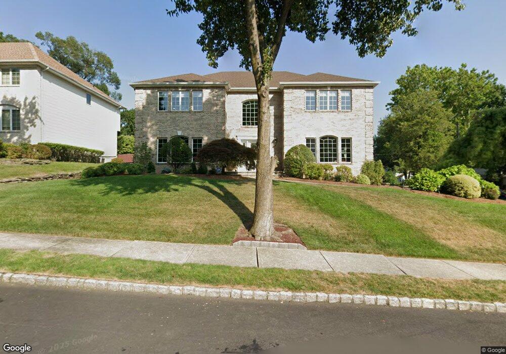
501 Manning Ct River Edge, NJ 07661
Estimated Value: $1,229,000 - $1,402,000
4
Beds
3
Baths
3,303
Sq Ft
$398/Sq Ft
Est. Value
About This Home
This home is located at 501 Manning Ct, River Edge, NJ 07661 and is currently estimated at $1,313,890, approximately $397 per square foot. 501 Manning Ct is a home located in Bergen County with nearby schools including Roosevelt Elementary School, River Dell Middle School, and River Dell Regional High School.
Ownership History
Date
Name
Owned For
Owner Type
Purchase Details
Closed on
May 1, 1996
Sold by
Mill Brook Estates
Bought by
Ignazzi Nicholas and Ignazzi Joyce
Current Estimated Value
Home Financials for this Owner
Home Financials are based on the most recent Mortgage that was taken out on this home.
Original Mortgage
$200,000
Outstanding Balance
$11,157
Interest Rate
7.77%
Estimated Equity
$1,302,733
Create a Home Valuation Report for This Property
The Home Valuation Report is an in-depth analysis detailing your home's value as well as a comparison with similar homes in the area
Home Values in the Area
Average Home Value in this Area
Purchase History
| Date | Buyer | Sale Price | Title Company |
|---|---|---|---|
| Ignazzi Nicholas | $450,000 | -- |
Source: Public Records
Mortgage History
| Date | Status | Borrower | Loan Amount |
|---|---|---|---|
| Open | Ignazzi Nicholas | $200,000 |
Source: Public Records
Tax History Compared to Growth
Tax History
| Year | Tax Paid | Tax Assessment Tax Assessment Total Assessment is a certain percentage of the fair market value that is determined by local assessors to be the total taxable value of land and additions on the property. | Land | Improvement |
|---|---|---|---|---|
| 2025 | $27,160 | $1,062,700 | $349,400 | $713,300 |
| 2024 | $26,482 | $685,000 | $247,400 | $437,600 |
| 2023 | $25,345 | $685,000 | $247,400 | $437,600 |
| 2022 | $25,345 | $685,000 | $247,400 | $437,600 |
| 2021 | $24,845 | $685,000 | $247,400 | $437,600 |
| 2020 | $24,455 | $685,000 | $247,400 | $437,600 |
| 2019 | $23,756 | $685,000 | $247,400 | $437,600 |
| 2018 | $23,256 | $685,000 | $247,400 | $437,600 |
| 2017 | $23,030 | $685,000 | $247,400 | $437,600 |
| 2016 | $22,509 | $685,000 | $247,400 | $437,600 |
| 2015 | $22,036 | $685,000 | $247,400 | $437,600 |
| 2014 | $24,276 | $753,200 | $247,400 | $505,800 |
Source: Public Records
Map
Nearby Homes
- 276 Greenway Terrace
- 215 Kensington Rd
- 168 Voorhis Ave
- 1 Sipporta Ln
- 189 Forest Ave Unit 409
- 189 Forest Ave Unit 303
- 150 Village Cir E
- 712 6th Ave
- 302 Howland Ave
- 122 Village Cir E
- 421 Lafayette Ave
- 378 Windsor Rd
- 761 6th Ave
- 766 7th Ave
- 81 Eastbrook Dr
- 331 Ellen Place
- 212 Lozier Terrace
- 784 Millbrook Rd
- 12 Gainesborough Terrace Unit 1B
- 42 Eastbrook Dr
- 292 Voorhis Ave
- 503 Manning Ct
- 288 Voorhis Ave
- 508 Manning Ct
- 506 Manning Ct
- 500 Manning Ct
- 291 Manning Ave
- 505 Manning Ct
- 291 Voorhis Ave
- 502 Manning Ct
- 504 Manning Ct
- 510 Manning Ct
- 284 Voorhis Ave
- 287 Manning Ave
- 287 Voorhis Ave
- 283 Manning Ave
- 283 Voorhis Ave
- 512 Manning Ct
- 485 5th Ave
- 504 Monroe Ct