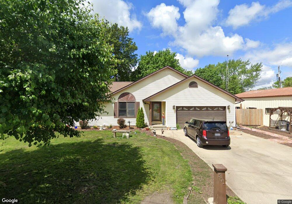
501 N 2nd St Mattoon, IL 61938
Estimated Value: $158,000 - $180,000
3
Beds
2
Baths
1,414
Sq Ft
$121/Sq Ft
Est. Value
About This Home
This home is located at 501 N 2nd St, Mattoon, IL 61938 and is currently estimated at $170,832, approximately $120 per square foot. 501 N 2nd St is a home located in Coles County with nearby schools including Mattoon High School, St. John's Lutheran School, and St Mary School.
Ownership History
Date
Name
Owned For
Owner Type
Purchase Details
Closed on
Aug 24, 2020
Sold by
Nale Martha Marie and Martha Marie Nale Revocable Tr
Bought by
Nale William and Nale Dianne
Current Estimated Value
Home Financials for this Owner
Home Financials are based on the most recent Mortgage that was taken out on this home.
Original Mortgage
$91,520
Outstanding Balance
$60,622
Interest Rate
2.5%
Mortgage Type
New Conventional
Estimated Equity
$110,210
Create a Home Valuation Report for This Property
The Home Valuation Report is an in-depth analysis detailing your home's value as well as a comparison with similar homes in the area
Home Values in the Area
Average Home Value in this Area
Purchase History
| Date | Buyer | Sale Price | Title Company |
|---|---|---|---|
| Nale William | $114,500 | Attorney |
Source: Public Records
Mortgage History
| Date | Status | Borrower | Loan Amount |
|---|---|---|---|
| Open | Nale William | $91,520 |
Source: Public Records
Tax History
| Year | Tax Paid | Tax Assessment Tax Assessment Total Assessment is a certain percentage of the fair market value that is determined by local assessors to be the total taxable value of land and additions on the property. | Land | Improvement |
|---|---|---|---|---|
| 2024 | $3,671 | $54,954 | $7,541 | $47,413 |
| 2023 | $3,173 | $49,508 | $6,794 | $42,714 |
| 2022 | $3,173 | $48,690 | $6,682 | $42,008 |
| 2021 | $3,049 | $43,865 | $6,020 | $37,845 |
| 2020 | $3,204 | $45,448 | $18,804 | $26,644 |
| 2019 | $2,287 | $43,865 | $18,149 | $25,716 |
| 2018 | $2,245 | $43,865 | $18,149 | $25,716 |
| 2017 | $2,241 | $43,865 | $18,149 | $25,716 |
| 2016 | $2,206 | $43,865 | $18,149 | $25,716 |
| 2015 | $2,265 | $43,005 | $17,793 | $25,212 |
| 2014 | $2,265 | $43,005 | $17,793 | $25,212 |
| 2013 | $2,265 | $43,005 | $17,793 | $25,212 |
Source: Public Records
Map
Nearby Homes
- 304 Dewitt Ave
- 421 Dewitt Ave
- 812 N 8th St Unit 64
- 812 N 8th St Unit 36
- 916 Piatt Ave
- 420 Crestview Dr
- 22 Elm Ridge
- 1101 Wabash Ave
- 1401 N 10th St
- 1 Brown Ct
- 1412 Champaign Ave
- 1301 Lafayette Ave
- 1312 Edgar Ave
- 1612 Richmond Ave
- 1012 S 6th St
- 1509 Lafayette Ave
- 309 Essex Ave
- 1800 Piatt Ave
- 1905 Dewitt Ave
- LOT 37 Broadmoor Edgewater
- 120 Shelby Ave
- 201,205,209 Moultrie Ave
- 201 Moultrie Ave
- 205 Moultrie Ave
- 121 Moultrie Ave
- 213 Moultrie Ave
- 221 Moultrie Ave
- 100 Shelby Ave
- 217 Moultrie Ave
- 105 Moultrie Ave
- 200 Moultrie Ave
- 301 Moultrie Ave
- 304 Shelby Ave
- 208 Moultrie Ave
- 120 Moultrie Ave
- 305 Moultrie Ave
- 201205209 Moultrie Ave
- 220 Moultrie Ave
- 320 N 3rd St
- 300 Moultrie Ave
Your Personal Tour Guide
Ask me questions while you tour the home.