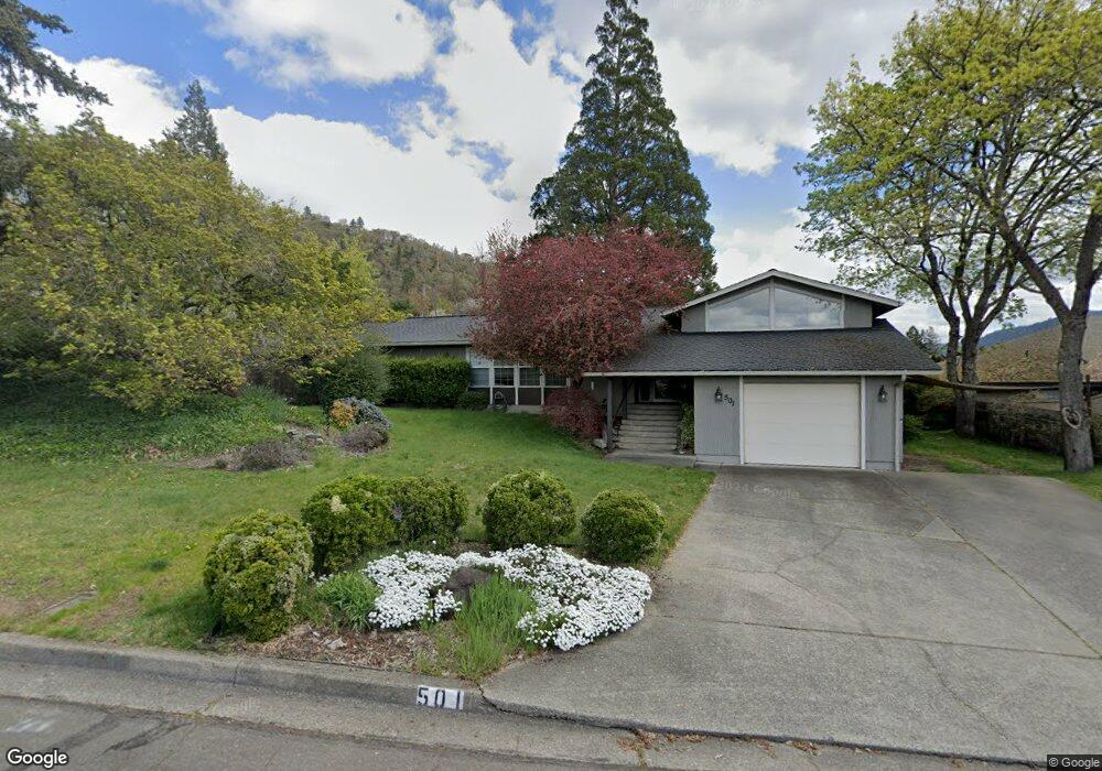
501 NE Royal Dr Grants Pass, OR 97526
Estimated Value: $416,000 - $420,704
3
Beds
2
Baths
1,857
Sq Ft
$225/Sq Ft
Est. Value
About This Home
This home is located at 501 NE Royal Dr, Grants Pass, OR 97526 and is currently estimated at $418,352, approximately $225 per square foot. 501 NE Royal Dr is a home located in Josephine County with nearby schools including Lincoln Elementary School, North Middle School, and Grants Pass High School.
Ownership History
Date
Name
Owned For
Owner Type
Purchase Details
Closed on
Mar 2, 2006
Sold by
Huddleston Darren S and Huddleston Heidi C
Bought by
Peterson Joel W and Peterson Susan M
Current Estimated Value
Home Financials for this Owner
Home Financials are based on the most recent Mortgage that was taken out on this home.
Original Mortgage
$260,000
Outstanding Balance
$144,979
Interest Rate
6.04%
Mortgage Type
Fannie Mae Freddie Mac
Estimated Equity
$273,373
Create a Home Valuation Report for This Property
The Home Valuation Report is an in-depth analysis detailing your home's value as well as a comparison with similar homes in the area
Home Values in the Area
Average Home Value in this Area
Purchase History
| Date | Buyer | Sale Price | Title Company |
|---|---|---|---|
| Peterson Joel W | $325,000 | First American |
Source: Public Records
Mortgage History
| Date | Status | Borrower | Loan Amount |
|---|---|---|---|
| Open | Peterson Joel W | $260,000 |
Source: Public Records
Tax History Compared to Growth
Tax History
| Year | Tax Paid | Tax Assessment Tax Assessment Total Assessment is a certain percentage of the fair market value that is determined by local assessors to be the total taxable value of land and additions on the property. | Land | Improvement |
|---|---|---|---|---|
| 2025 | $3,218 | $247,820 | -- | -- |
| 2024 | $3,218 | $240,610 | -- | -- |
| 2023 | $3,125 | $233,610 | $0 | $0 |
| 2022 | $3,046 | $226,810 | -- | -- |
| 2021 | $2,861 | $220,210 | $0 | $0 |
| 2020 | $2,778 | $213,800 | $0 | $0 |
| 2019 | $2,698 | $207,580 | $0 | $0 |
| 2018 | $2,745 | $201,540 | $0 | $0 |
| 2017 | $2,725 | $195,670 | $0 | $0 |
| 2016 | $2,395 | $189,980 | $0 | $0 |
| 2015 | $2,317 | $184,450 | $0 | $0 |
| 2014 | $2,254 | $179,080 | $0 | $0 |
Source: Public Records
Map
Nearby Homes
- 409 NE Royal Dr
- 1752 NE Foothill Blvd
- 2060 NE Fairview Ave
- 1405 NE Laura Ct
- 418 NE 11th St
- 419 NE Silverwood Place
- 431 NE Silverwood Place
- 425 NE Silverwood Place
- 909 NE 11th St
- 946 NE 12th St
- 918 NE 10th St
- 715 NE A St
- 811 NE Clyde Place
- 811 NE Clyde Place Unit 116 C
- 702 NE A St
- 4424 Foothill Blvd
- 1117 NE Memorial Dr
- 905 SE Fern St
- 331 NE Fetzner St
- 1708 Softwood Way
- 433 NE Royal Dr
- 1601 NE Foothill Blvd
- 1625 NE Foothill Blvd
- 1627 NE Foothill Blvd
- 504 NE Royal Dr
- 504 NE Royal Dr Unit 2805
- 431 NE Royal Dr
- 440 NE Royal Dr
- 1629 NE Foothill Blvd
- 432 NE Royal Dr
- 510 NE Royal Dr
- 462 NE Sovereign Ave
- 1620 NE Foothill Blvd
- 425 NE Royal Dr
- 1645 NE Foothill Blvd
- 1630 NE Foothill Blvd
- 439 NE Sovereign Ave
- 1555 NE A St
- 426 NE Royal Dr
- 456 NE Sovereign Ave