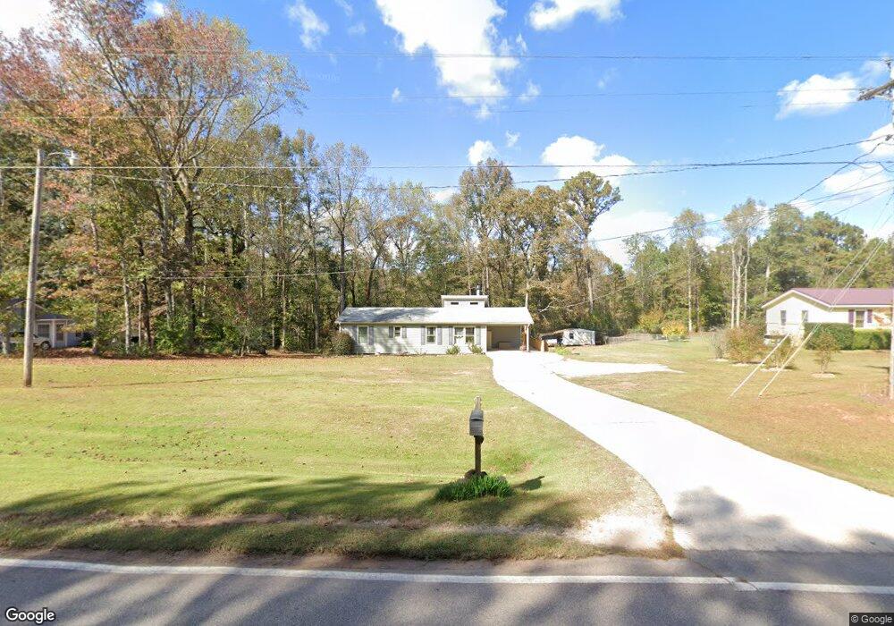
5010 Old West Point Rd Lagrange, GA 30240
Estimated Value: $181,000 - $209,000
3
Beds
2
Baths
1,080
Sq Ft
$178/Sq Ft
Est. Value
About This Home
This home is located at 5010 Old West Point Rd, Lagrange, GA 30240 and is currently estimated at $192,196, approximately $177 per square foot. 5010 Old West Point Rd is a home located in Troup County with nearby schools including Long Cane Elementary School, Berta Weathersbee Elementary School, and Whitesville Road Elementary School.
Ownership History
Date
Name
Owned For
Owner Type
Purchase Details
Closed on
Aug 22, 1997
Sold by
Don Rainey'S Food Store
Bought by
Schoonover Eric C and Schoonover Kathryn L
Current Estimated Value
Purchase Details
Closed on
Apr 15, 1994
Sold by
First Federal Savings Bank
Bought by
Don Rainey'S Food Store
Purchase Details
Closed on
Mar 4, 1994
Sold by
Hancock J
Bought by
First Federal Savings Bank
Purchase Details
Closed on
Aug 7, 1990
Bought by
Hancock J
Purchase Details
Closed on
Dec 1, 1986
Purchase Details
Closed on
Feb 28, 1978
Purchase Details
Closed on
Aug 18, 1977
Purchase Details
Closed on
May 30, 1975
Purchase Details
Closed on
Jan 1, 1954
Create a Home Valuation Report for This Property
The Home Valuation Report is an in-depth analysis detailing your home's value as well as a comparison with similar homes in the area
Purchase History
| Date | Buyer | Sale Price | Title Company |
|---|---|---|---|
| Schoonover Eric C | $65,000 | -- | |
| Don Rainey'S Food Store | $46,000 | -- | |
| First Federal Savings Bank | -- | -- | |
| Hancock J | $57,000 | -- | |
| -- | $26,800 | -- | |
| -- | $31,500 | -- | |
| -- | -- | -- | |
| -- | -- | -- | |
| -- | -- | -- |
Source: Public Records
Tax History
| Year | Tax Paid | Tax Assessment Tax Assessment Total Assessment is a certain percentage of the fair market value that is determined by local assessors to be the total taxable value of land and additions on the property. | Land | Improvement |
|---|---|---|---|---|
| 2025 | $1,588 | $61,352 | $14,000 | $47,352 |
| 2024 | $1,532 | $58,152 | $14,000 | $44,152 |
| 2023 | $1,525 | $57,912 | $14,000 | $43,912 |
| 2022 | $1,401 | $52,192 | $10,000 | $42,192 |
| 2021 | $1,178 | $41,040 | $10,000 | $31,040 |
| 2020 | $1,057 | $37,040 | $6,000 | $31,040 |
| 2019 | $1,011 | $35,520 | $6,000 | $29,520 |
| 2018 | $758 | $27,112 | $6,000 | $21,112 |
| 2017 | $758 | $27,112 | $6,000 | $21,112 |
| 2016 | $736 | $26,392 | $6,000 | $20,392 |
| 2015 | $737 | $26,358 | $6,000 | $20,358 |
| 2014 | $705 | $25,287 | $6,000 | $19,287 |
| 2013 | -- | $26,324 | $6,000 | $20,324 |
Source: Public Records
Map
Nearby Homes
- 105 Redwood Dr
- 3009 Old West Point Rd
- 22 Freeman Rd
- 0 Glass Bridge Rd Unit 10679358
- 288 Bradfield Dr
- 640 Hudson Rd
- 266 Glass Bridge Rd
- 808 S Fling Rd
- 2239 Pegasus Pkwy
- 0 Bradfield Dr Unit 10568803
- 8 Horace Carter Rd
- 427 Fling Rd
- 509 Connie Dr
- 112 Foxdale Dr
- 402 Ginger Cir
- 119 Plymouth Dr
- 0 Cannonville Rd
- 102 Bridgewater Dr
- 113 Colonial Ct Unit 100
- 311 Cumberland Dr
- 5008 Old West Point Rd
- 5012 Old West Point Rd
- 5006 Old West Point Rd
- 101 Redwood Dr
- 100 Redwood Dr
- 5004 Old West Point Rd
- 5014 Old West Point Rd
- 5005 Old West Point Rd
- 5018 Old West Point Rd
- 5002 Old West Point Rd
- 102 Redwood Dr
- 103 Redwood Dr
- 25 George Daniel Rd
- 5003 Old West Point Rd
- 5020 Old West Point Rd
- 5017 Old West Point Rd
- 0 Rob Roy Rd Unit 7375355
- 0 Rob Roy Rd Unit 8205602
- 5000 Old West Point Rd
- 39 George Daniel Rd
Your Personal Tour Guide
Ask me questions while you tour the home.