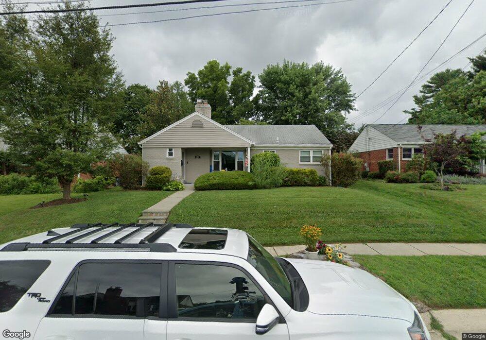
5011 Cushing Dr Kensington, MD 20895
Estimated Value: $761,000 - $811,000
3
Beds
2
Baths
1,142
Sq Ft
$688/Sq Ft
Est. Value
About This Home
This home is located at 5011 Cushing Dr, Kensington, MD 20895 and is currently estimated at $785,754, approximately $688 per square foot. 5011 Cushing Dr is a home located in Montgomery County with nearby schools including Garrett Park Elementary School, Tilden Middle School, and Walter Johnson High School.
Ownership History
Date
Name
Owned For
Owner Type
Purchase Details
Closed on
Sep 9, 2024
Sold by
Yerkie Jason
Bought by
Yerkie Jason and Yerkie Meadow
Current Estimated Value
Purchase Details
Closed on
Jun 9, 2011
Sold by
Luther Mark E
Bought by
Yerkie Jason
Purchase Details
Closed on
May 20, 2011
Sold by
Luther Mark E and Luther Paola
Bought by
Yerkie Jason
Purchase Details
Closed on
Feb 2, 2011
Sold by
Search Cecile F /Tr
Bought by
Luther Mark E and Luther Paola
Purchase Details
Closed on
Jan 26, 2011
Sold by
Search Cecile F /Tr
Bought by
Luther Mark E and Luther Paola
Purchase Details
Closed on
Feb 25, 2004
Sold by
Search Harry E & C F
Bought by
Search Cecile F Tr
Create a Home Valuation Report for This Property
The Home Valuation Report is an in-depth analysis detailing your home's value as well as a comparison with similar homes in the area
Home Values in the Area
Average Home Value in this Area
Purchase History
| Date | Buyer | Sale Price | Title Company |
|---|---|---|---|
| Yerkie Jason | -- | None Listed On Document | |
| Yerkie Jason | $546,200 | -- | |
| Yerkie Jason | $546,200 | First American Title Ins Co | |
| Yerkie Jason | $546,200 | -- | |
| Luther Mark E | $385,000 | -- | |
| Luther Mark E | $385,000 | -- | |
| Search Cecile F Tr | -- | -- | |
| Search Cecile F Tr | -- | -- |
Source: Public Records
Tax History Compared to Growth
Tax History
| Year | Tax Paid | Tax Assessment Tax Assessment Total Assessment is a certain percentage of the fair market value that is determined by local assessors to be the total taxable value of land and additions on the property. | Land | Improvement |
|---|---|---|---|---|
| 2025 | $7,197 | $582,367 | -- | -- |
| 2024 | $7,197 | $561,633 | $0 | $0 |
| 2023 | $6,243 | $540,900 | $349,700 | $191,200 |
| 2022 | $5,747 | $524,267 | $0 | $0 |
| 2021 | $5,279 | $507,633 | $0 | $0 |
| 2020 | $5,279 | $491,000 | $333,000 | $158,000 |
| 2019 | $5,123 | $480,100 | $0 | $0 |
| 2018 | $4,981 | $469,200 | $0 | $0 |
| 2017 | $4,941 | $458,300 | $0 | $0 |
| 2016 | $5,176 | $439,133 | $0 | $0 |
| 2015 | $5,176 | $419,967 | $0 | $0 |
| 2014 | $5,176 | $400,800 | $0 | $0 |
Source: Public Records
Map
Nearby Homes
- 5000 Bangor Dr
- 4907 Bangor Dr
- 11105 Waycross Way
- 5006 Flanders Ave
- 5024 Strathmore Ave
- 5026 Strathmore Ave
- 11013 Stillwater Ave
- The Coltrane Plan at Strathmore View
- 4910 Strathmore Ave Unit NAVARRO 40
- The Navarro Plan at Strathmore View
- 4910 Strathmore Ave Unit NAVARRO 74
- The Strathmore Plan at Strathmore View
- The Ellington Plan at Strathmore View
- 4910 Strathmore Ave Unit HOMESITE 37
- 4910 Strathmore Ave Unit COLTRANE 92
- 5009 Flanders Ave
- 5201 Bangor Dr
- 5110 Flanders Ave
- 10890 Symphony Park Dr
- 5229 Strathmore Ave
- 5009 Cushing Dr
- 5013 Cushing Dr
- 5012 Druid Dr
- 5010 Druid Dr
- 5007 Cushing Dr
- 5014 Druid Dr
- 5008 Druid Dr
- 5008 Cushing Dr
- 5016 Druid Dr
- 5017 Cushing Dr
- 5005 Cushing Dr
- 5006 Druid Dr
- 5004 Cushing Dr
- 5010 Cushing Dr
- 5002 Cushing Dr
- 5018 Druid Dr
- 5012 Cushing Dr
- 5004 Druid Dr
- 5019 Cushing Dr
- 5003 Cushing Dr