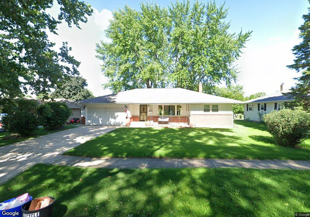
5011 Upland Dr Rockford, IL 61108
Estimated Value: $172,615 - $228,000
3
Beds
2
Baths
1,410
Sq Ft
$139/Sq Ft
Est. Value
About This Home
This home is located at 5011 Upland Dr, Rockford, IL 61108 and is currently estimated at $195,904, approximately $138 per square foot. 5011 Upland Dr is a home located in Winnebago County with nearby schools including A C Thompson Elementary School, Bernard W. Flinn Middle School, and Rockford East High School.
Ownership History
Date
Name
Owned For
Owner Type
Purchase Details
Closed on
Mar 25, 2021
Sold by
Brongiel Thomas D and Brongiel Nichole M
Bought by
Brongiel Thomas D
Current Estimated Value
Home Financials for this Owner
Home Financials are based on the most recent Mortgage that was taken out on this home.
Original Mortgage
$73,600
Outstanding Balance
$66,177
Interest Rate
2.88%
Mortgage Type
New Conventional
Estimated Equity
$129,727
Purchase Details
Closed on
Feb 28, 2003
Bought by
Brongiel Thomas D and Brongiel Nichole M
Create a Home Valuation Report for This Property
The Home Valuation Report is an in-depth analysis detailing your home's value as well as a comparison with similar homes in the area
Home Values in the Area
Average Home Value in this Area
Purchase History
| Date | Buyer | Sale Price | Title Company |
|---|---|---|---|
| Brongiel Thomas D | -- | Ravenswood Title | |
| Brongiel Thomas D | $99,000 | -- |
Source: Public Records
Mortgage History
| Date | Status | Borrower | Loan Amount |
|---|---|---|---|
| Open | Brongiel Thomas D | $73,600 |
Source: Public Records
Tax History Compared to Growth
Tax History
| Year | Tax Paid | Tax Assessment Tax Assessment Total Assessment is a certain percentage of the fair market value that is determined by local assessors to be the total taxable value of land and additions on the property. | Land | Improvement |
|---|---|---|---|---|
| 2024 | $3,749 | $45,565 | $6,439 | $39,126 |
| 2023 | $3,549 | $40,178 | $5,678 | $34,500 |
| 2022 | $3,418 | $35,912 | $5,075 | $30,837 |
| 2021 | $3,058 | $30,954 | $4,652 | $26,302 |
| 2020 | $2,991 | $29,263 | $4,398 | $24,865 |
| 2019 | $2,933 | $27,891 | $4,192 | $23,699 |
| 2018 | $2,696 | $26,286 | $3,951 | $22,335 |
| 2017 | $2,842 | $25,156 | $3,781 | $21,375 |
| 2016 | $2,466 | $22,324 | $3,710 | $18,614 |
| 2015 | $2,497 | $22,324 | $3,710 | $18,614 |
| 2014 | $3,593 | $24,214 | $4,626 | $19,588 |
Source: Public Records
Map
Nearby Homes
- 4805 Waukegan Dr
- 4216 Dakota Ln
- 2225 Welworth Ave
- 3928 Seward Ave
- 69XX Charles St
- 5334 Dierks Dr Unit 12
- 5384 Dierks Dr
- 5384 Dierks Dr Unit 17
- 3713 Connecticut Dr
- 1721 Nixon Ct
- 3520 Thelma St
- 2715 Colorado Ave
- 3419 Green Dale Dr
- 3511 Carolina Ave
- 3332 Wesleyan Ave
- 1529 Kerstin Ct
- 2335 Cornell Dr
- 3304 Chadwick Dr
- 2724 Norway Pine Rd
- 3243 Carolina Ave
- 5007 Upland Dr
- 5015 Upland Dr
- 5003 Upland Dr
- 5019 Upland Dr
- 5016 Upland Dr
- 5020 Upland Dr
- 4915 Upland Dr
- 5103 Upland Dr
- 5012 Upland Dr
- 2510 Holmes St Unit 2
- 5008 Upland Dr
- 5104 Upland Dr
- 4911 Upland Dr
- 5004 Upland Dr
- 5107 Upland Dr
- 2625 Skokie Dr
- 5108 Upland Dr
- 4907 Upland Dr
- 4705 Waukegan Dr
- 2507 Holmes St